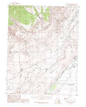
Harrisburg Junction Topo Map Utah
To zoom in, hover over the map of Harrisburg Junction
USGS Topo Quad 37113b4 - 1:24,000 scale
| Topo Map Name: | Harrisburg Junction |
| USGS Topo Quad ID: | 37113b4 |
| Print Size: | ca. 21 1/4" wide x 27" high |
| Southeast Coordinates: | 37.125° N latitude / 113.375° W longitude |
| Map Center Coordinates: | 37.1875° N latitude / 113.4375° W longitude |
| U.S. State: | UT |
| Filename: | o37113b4.jpg |
| Download Map JPG Image: | Harrisburg Junction topo map 1:24,000 scale |
| Map Type: | Topographic |
| Topo Series: | 7.5´ |
| Map Scale: | 1:24,000 |
| Source of Map Images: | United States Geological Survey (USGS) |
| Alternate Map Versions: |
La Verkin 3 NW UT 1954, updated 1956 Download PDF Buy paper map Harrisburg Junction UT 1986, updated 1987 Download PDF Buy paper map Harrisburg Junction UT 2011 Download PDF Buy paper map Harrisburg Junction UT 2014 Download PDF Buy paper map |
| FStopo: | US Forest Service topo Harrisburg Junction is available: Download FStopo PDF Download FStopo TIF |
1:24,000 Topo Quads surrounding Harrisburg Junction
> Back to 37113a1 at 1:100,000 scale
> Back to 37112a1 at 1:250,000 scale
> Back to U.S. Topo Maps home
Harrisburg Junction topo map: Gazetteer
Harrisburg Junction: Benches
Harrisburg Bench elevation 1096m 3595′Harrisburg Junction: Flats
Harrisburg Flat elevation 941m 3087′Purgatory Flat elevation 877m 2877′
Yant Flat elevation 1377m 4517′
Harrisburg Junction: Gaps
Grapevine Pass elevation 968m 3175′Harrisburg Gap elevation 854m 2801′
Harrisburg Junction: Mines
Cobb Mine elevation 1080m 3543′Harrisburg Junction: Populated Places
Harrisburg elevation 914m 2998′Harrisburg Junction elevation 955m 3133′
Harrisburg Junction: Ridges
Leeds Reef elevation 1053m 3454′Red Reef elevation 999m 3277′
Washington Black Ridge elevation 965m 3166′
White Reef elevation 1133m 3717′
Harrisburg Junction: Springs
Berry Spring elevation 852m 2795′Cottonwood Spring elevation 941m 3087′
Sand Mountain Spring elevation 876m 2874′
Willow Spring elevation 878m 2880′
Harrisburg Junction: Streams
Bitter Creek elevation 1281m 4202′Cottonwood Creek elevation 1281m 4202′
Harrisburg Creek elevation 850m 2788′
Leeds Creek elevation 945m 3100′
Quail Creek elevation 851m 2791′
Yankee Doodle Hollow Creek elevation 1238m 4061′
Harrisburg Junction: Summits
Cottonwood Hill elevation 990m 3248′Harrisburg Dome elevation 902m 2959′
Harrisburg Junction: Valleys
Big Hollow elevation 1235m 4051′Cottonwood Canyon elevation 992m 3254′
Cottonwood Wash elevation 815m 2673′
Dicks Canyon elevation 989m 3244′
Harrisburg Canyon elevation 852m 2795′
Heath Wash elevation 1086m 3562′
Water Canyon elevation 980m 3215′
Yankee Doodle Hollow elevation 1238m 4061′
Harrisburg Junction digital topo map on disk
Buy this Harrisburg Junction topo map showing relief, roads, GPS coordinates and other geographical features, as a high-resolution digital map file on DVD:


