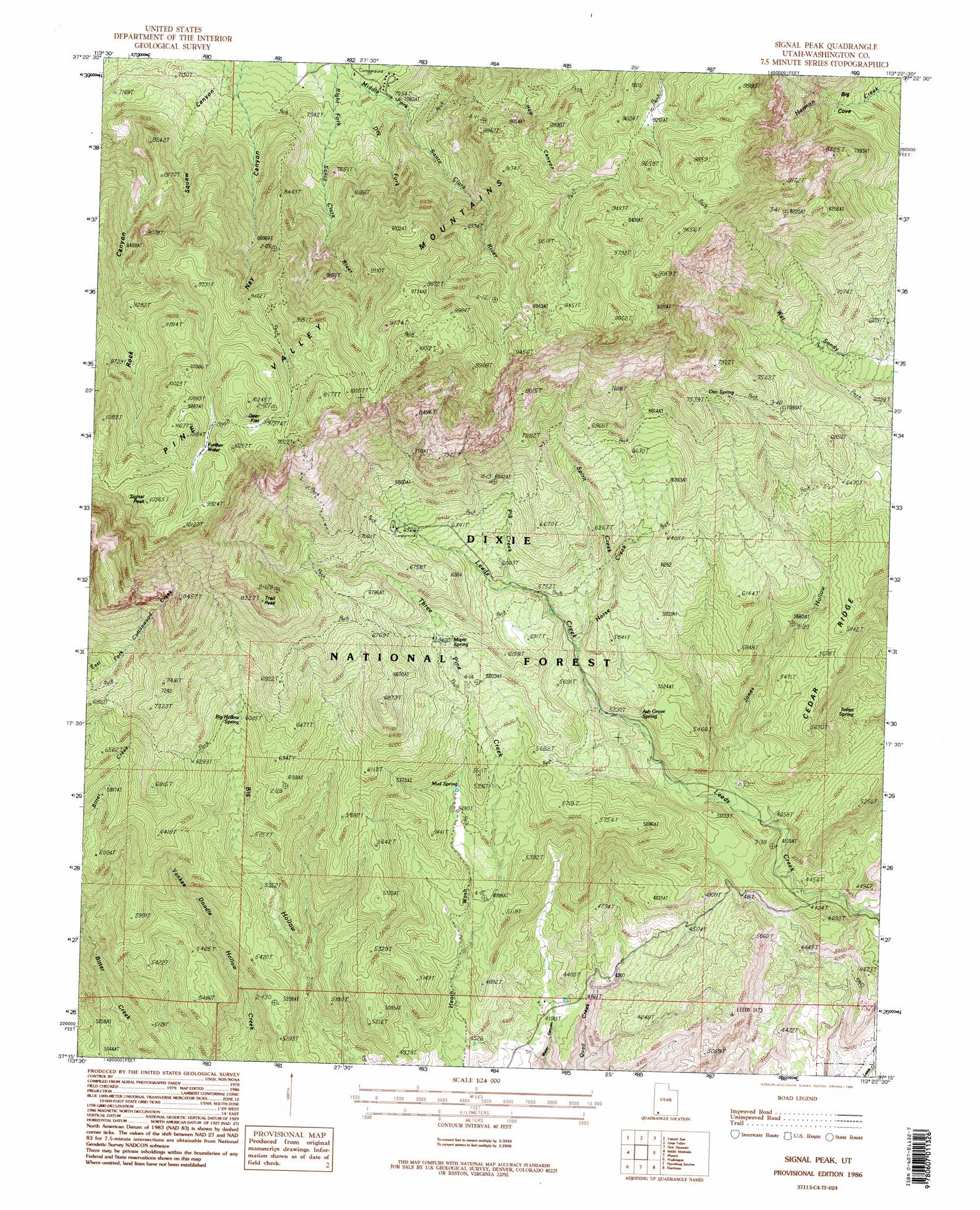
Signal Peak Topo Map Utah
To zoom in, hover over the map of Signal Peak
USGS Topo Quad 37113c4 - 1:24,000 scale
| Topo Map Name: | Signal Peak |
| USGS Topo Quad ID: | 37113c4 |
| Print Size: | ca. 21 1/4" wide x 27" high |
| Southeast Coordinates: | 37.25° N latitude / 113.375° W longitude |
| Map Center Coordinates: | 37.3125° N latitude / 113.4375° W longitude |
| U.S. State: | UT |
| Filename: | o37113c4.jpg |
| Download Map JPG Image: | Signal Peak topo map 1:24,000 scale |
| Map Type: | Topographic |
| Topo Series: | 7.5´ |
| Map Scale: | 1:24,000 |
| Source of Map Images: | United States Geological Survey (USGS) |
| Alternate Map Versions: |
Signal Peak UT 1986, updated 1987 Download PDF Buy paper map Signal Peak UT 1986, updated 1995 Download PDF Buy paper map Signal Peak UT 1986, updated 1995 Download PDF Buy paper map Signal Peak UT 2002, updated 2005 Download PDF Buy paper map Signal Peak UT 2011 Download PDF Buy paper map Signal Peak UT 2014 Download PDF Buy paper map |
| FStopo: | US Forest Service topo Signal Peak is available: Download FStopo PDF Download FStopo TIF |
1:24,000 Topo Quads surrounding Signal Peak
Enterprise |
Pinto |
Page Ranch |
Stoddard Mountain |
Kanarraville |
Central West |
Central East |
Grass Valley |
New Harmony |
Kolob Arch |
Veyo |
Saddle Mountain |
Signal Peak |
Pintura |
Smith Mesa |
Santa Clara |
Washington |
Harrisburg Junction |
Hurricane |
Virgin |
White Hills |
Saint George |
Washington Dome |
The Divide |
Little Creek Mountain |
> Back to 37113a1 at 1:100,000 scale
> Back to 37112a1 at 1:250,000 scale
> Back to U.S. Topo Maps home
Signal Peak topo map: Gazetteer
Signal Peak: Basins
Big Cove elevation 1993m 6538′South Valley elevation 2809m 9215′
Signal Peak: Flats
Deer Flat elevation 2997m 9832′Signal Peak: Lakes
Further Water elevation 2988m 9803′Signal Peak: Parks
Oak Grove Recreation Area elevation 1993m 6538′Pine Valley Recreation Area elevation 2143m 7030′
Signal Peak: Reservoirs
Jones Hollow Reservoir elevation 1876m 6154′Signal Peak: Ridges
Cedar Ridge elevation 1716m 5629′Signal Peak: Springs
Ash Grove Spring elevation 1668m 5472′Big Hollow Spring elevation 1862m 6108′
Columbine Spring elevation 2142m 7027′
Dan Spring elevation 2194m 7198′
Italian Spring elevation 1388m 4553′
Maple Spring elevation 1842m 6043′
Mud Spring elevation 1683m 5521′
Signal Peak: Streams
Big Creek elevation 1785m 5856′Dry Fork elevation 2111m 6925′
Horse Creek elevation 1675m 5495′
Pig Creek elevation 1794m 5885′
Right Fork Santa Clara River elevation 2087m 6847′
Spirit Creek elevation 1709m 5606′
Three Pine Creek elevation 1445m 4740′
Signal Peak: Summits
Signal Peak elevation 3159m 10364′Trail Peak elevation 2525m 8284′
Signal Peak: Trails
Big Hollow Trail elevation 1656m 5433′Blake Harmony Trail elevation 1910m 6266′
Browns Point Trail elevation 2575m 8448′
Highline Trail elevation 2071m 6794′
Oak Grove Trail elevation 2548m 8359′
Point Trail elevation 2582m 8471′
West Summit Trail elevation 2403m 7883′
Whipple Trail elevation 2634m 8641′
Signal Peak: Valleys
Jones Hollow elevation 1403m 4603′Signal Peak digital topo map on disk
Buy this Signal Peak topo map showing relief, roads, GPS coordinates and other geographical features, as a high-resolution digital map file on DVD: