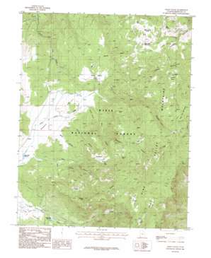
Grass Valley Topo Map Utah
To zoom in, hover over the map of Grass Valley
USGS Topo Quad 37113d4 - 1:24,000 scale
| Topo Map Name: | Grass Valley |
| USGS Topo Quad ID: | 37113d4 |
| Print Size: | ca. 21 1/4" wide x 27" high |
| Southeast Coordinates: | 37.375° N latitude / 113.375° W longitude |
| Map Center Coordinates: | 37.4375° N latitude / 113.4375° W longitude |
| U.S. State: | UT |
| Filename: | o37113d4.jpg |
| Download Map JPG Image: | Grass Valley topo map 1:24,000 scale |
| Map Type: | Topographic |
| Topo Series: | 7.5´ |
| Map Scale: | 1:24,000 |
| Source of Map Images: | United States Geological Survey (USGS) |
| Alternate Map Versions: |
Grass Valley UT 1986, updated 1987 Download PDF Buy paper map Grass Valley UT 1986, updated 1987 Download PDF Buy paper map Grass Valley UT 2002, updated 2005 Download PDF Buy paper map Grass Valley UT 2011 Download PDF Buy paper map Grass Valley UT 2014 Download PDF Buy paper map |
| FStopo: | US Forest Service topo Grass Valley is available: Download FStopo PDF Download FStopo TIF |
1:24,000 Topo Quads surrounding Grass Valley
> Back to 37113a1 at 1:100,000 scale
> Back to 37112a1 at 1:250,000 scale
> Back to U.S. Topo Maps home
Grass Valley topo map: Gazetteer
Grass Valley: Basins
Bare Valley elevation 2619m 8592′Sheep Pens elevation 2564m 8412′
Whipple Valley elevation 2766m 9074′
Grass Valley: Benches
The Bench elevation 2617m 8585′Wood Bench elevation 2267m 7437′
Grass Valley: Capes
Mahogany Point elevation 2451m 8041′Grass Valley: Dams
Grass Valley Dam elevation 2102m 6896′Pine Valley Reservoir Dam elevation 2053m 6735′
Grass Valley: Flats
Bens Pasture elevation 2414m 7919′Dry Flat elevation 2292m 7519′
Jodes Flat elevation 2536m 8320′
Jodes Flat elevation 2492m 8175′
Mill Flat elevation 2620m 8595′
Teds Pasture elevation 2720m 8923′
Grass Valley: Lakes
Big Water elevation 2375m 7791′First Water elevation 2649m 8690′
Second Water elevation 2620m 8595′
Grass Valley: Parks
Pine Valley Recreation Area elevation 2042m 6699′Grass Valley: Ranges
Pine Valley Mountains elevation 3028m 9934′Grass Valley: Reservoirs
Grass Valley Reservoir elevation 2100m 6889′Pine Valley Reservoir elevation 2053m 6735′
White Rocks Reservoir elevation 2428m 7965′
Grass Valley: Ridges
Pine Ridge elevation 2758m 9048′Grass Valley: Springs
Bench Spring elevation 2219m 7280′First Water Spring elevation 2651m 8697′
Second Water Spring elevation 2644m 8674′
Sheep Pen Spring elevation 2471m 8106′
Slew Spring elevation 2440m 8005′
Grass Valley: Streams
Left Fork Santa Clara River elevation 2096m 6876′Middle Fork Santa Clara River elevation 2086m 6843′
Grass Valley: Summits
Big Point elevation 3049m 10003′Gardner Peak elevation 2879m 9445′
Timber Mountain elevation 2694m 8838′
Grass Valley: Trails
Gardner Peak Trail elevation 2141m 7024′Grass Valley Trail elevation 2458m 8064′
Reservoir Canyon Trail elevation 2309m 7575′
Water Canyon Trail elevation 2737m 8979′
White Rocks Trail elevation 2437m 7995′
Grass Valley: Valleys
Bark Hollow elevation 2243m 7358′Burnt Canyon elevation 2337m 7667′
Cougar Canyon elevation 2172m 7125′
Grassy Flat Canyon elevation 1943m 6374′
Hop Canyon elevation 2185m 7168′
Main Canyon elevation 2168m 7112′
Middle Fork Water Canyon elevation 2199m 7214′
Mill Canyon elevation 2171m 7122′
Nay Canyon elevation 2051m 6729′
North Valley elevation 2792m 9160′
Reservoir Canyon elevation 2282m 7486′
Right Fork Water Canyon elevation 2173m 7129′
Spring Hollow elevation 2162m 7093′
Squaw Canyon elevation 2032m 6666′
Water Canyon elevation 2114m 6935′
West Valley elevation 2774m 9101′
White Rocks Draw elevation 2172m 7125′
Wide Hollow elevation 2139m 7017′
Grass Valley digital topo map on disk
Buy this Grass Valley topo map showing relief, roads, GPS coordinates and other geographical features, as a high-resolution digital map file on DVD:


