Maple Ridge Topo Map Utah
To zoom in, hover over the map of Maple Ridge
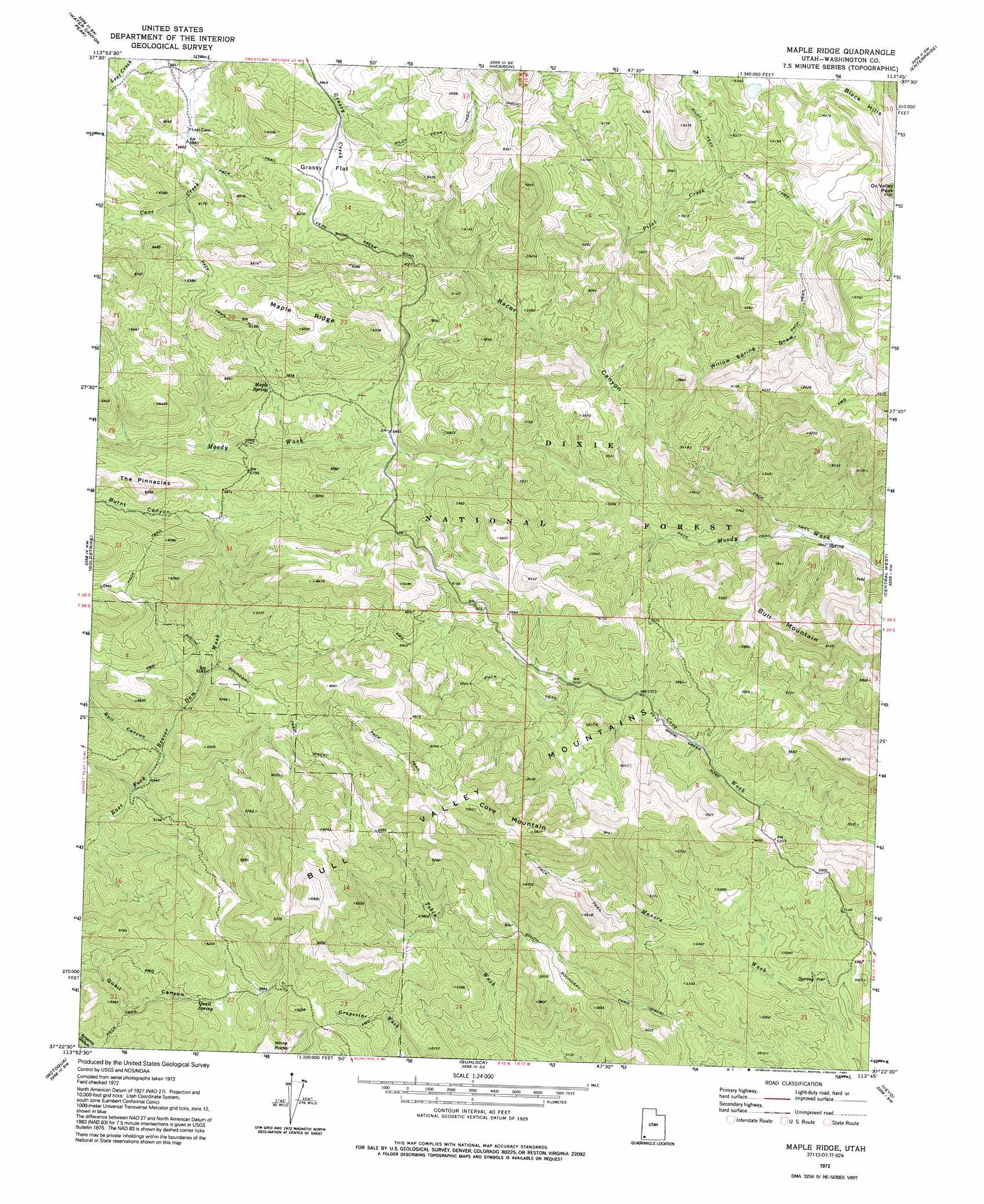
USGS Topo Quad 37113d7 - 1:24,000 scale
| Topo Map Name: | Maple Ridge |
| USGS Topo Quad ID: | 37113d7 |
| Print Size: | ca. 21 1/4" wide x 27" high |
| Southeast Coordinates: | 37.375° N latitude / 113.75° W longitude |
| Map Center Coordinates: | 37.4375° N latitude / 113.8125° W longitude |
| U.S. State: | UT |
| Filename: | o37113d7.jpg |
| Download Map JPG Image: | Maple Ridge topo map 1:24,000 scale |
| Map Type: | Topographic |
| Topo Series: | 7.5´ |
| Map Scale: | 1:24,000 |
| Source of Map Images: | United States Geological Survey (USGS) |
| Alternate Map Versions: |
Maple Ridge UT 1972, updated 1976 Download PDF Buy paper map Maple Ridge UT 1972, updated 1992 Download PDF Buy paper map Maple Ridge UT 2002, updated 2005 Download PDF Buy paper map Maple Ridge UT 2011 Download PDF Buy paper map Maple Ridge UT 2014 Download PDF Buy paper map |
| FStopo: | US Forest Service topo Maple Ridge is available: Download FStopo PDF Download FStopo TIF |
1:24,000 Topo Quads surrounding Maple Ridge
Uvada |
Mount Escalante |
Pinon Point |
Beryl Junction |
Newcastle |
Pine Park |
Water Canyon Peak |
Hebron |
Enterprise |
Pinto |
Docs Pass |
Goldstrike |
Maple Ridge |
Central West |
Central East |
Dodge Spring |
Motoqua |
Gunlock |
Veyo |
Saddle Mountain |
Scarecrow Peak |
West Mountain Peak |
Shivwits |
Santa Clara |
Washington |
> Back to 37113a1 at 1:100,000 scale
> Back to 37112a1 at 1:250,000 scale
> Back to U.S. Topo Maps home
Maple Ridge topo map: Gazetteer
Maple Ridge: Flats
Grassy Flat elevation 1827m 5994′Maple Ridge: Lakes
Ox Valley Lake elevation 1890m 6200′Maple Ridge: Ranges
Bull Valley Mountains elevation 2133m 6998′Maple Ridge: Ridges
Maple Ridge elevation 1909m 6263′Maple Ridge: Springs
Doc Watson Spring elevation 1458m 4783′Maple Spring elevation 1754m 5754′
Quail Spring elevation 1704m 5590′
Maple Ridge: Streams
Pilot Creek elevation 1626m 5334′Racer Canyon Creek elevation 1540m 5052′
Maple Ridge: Summits
Bull Mountain elevation 1960m 6430′Cove Mountain elevation 2079m 6820′
Ox Valley Peak elevation 2035m 6676′
The Pinnacles elevation 1918m 6292′
White Rocks elevation 1761m 5777′
Windy Peak elevation 2086m 6843′
Maple Ridge: Trails
South Boundary Trail elevation 1739m 5705′Maple Ridge: Valleys
Bull Canyon elevation 1527m 5009′Burnt Canyon elevation 1708m 5603′
Racer Canyon elevation 1517m 4977′
Willow Spring Draw elevation 1593m 5226′
Maple Ridge digital topo map on disk
Buy this Maple Ridge topo map showing relief, roads, GPS coordinates and other geographical features, as a high-resolution digital map file on DVD: