Page Ranch Topo Map Utah
To zoom in, hover over the map of Page Ranch
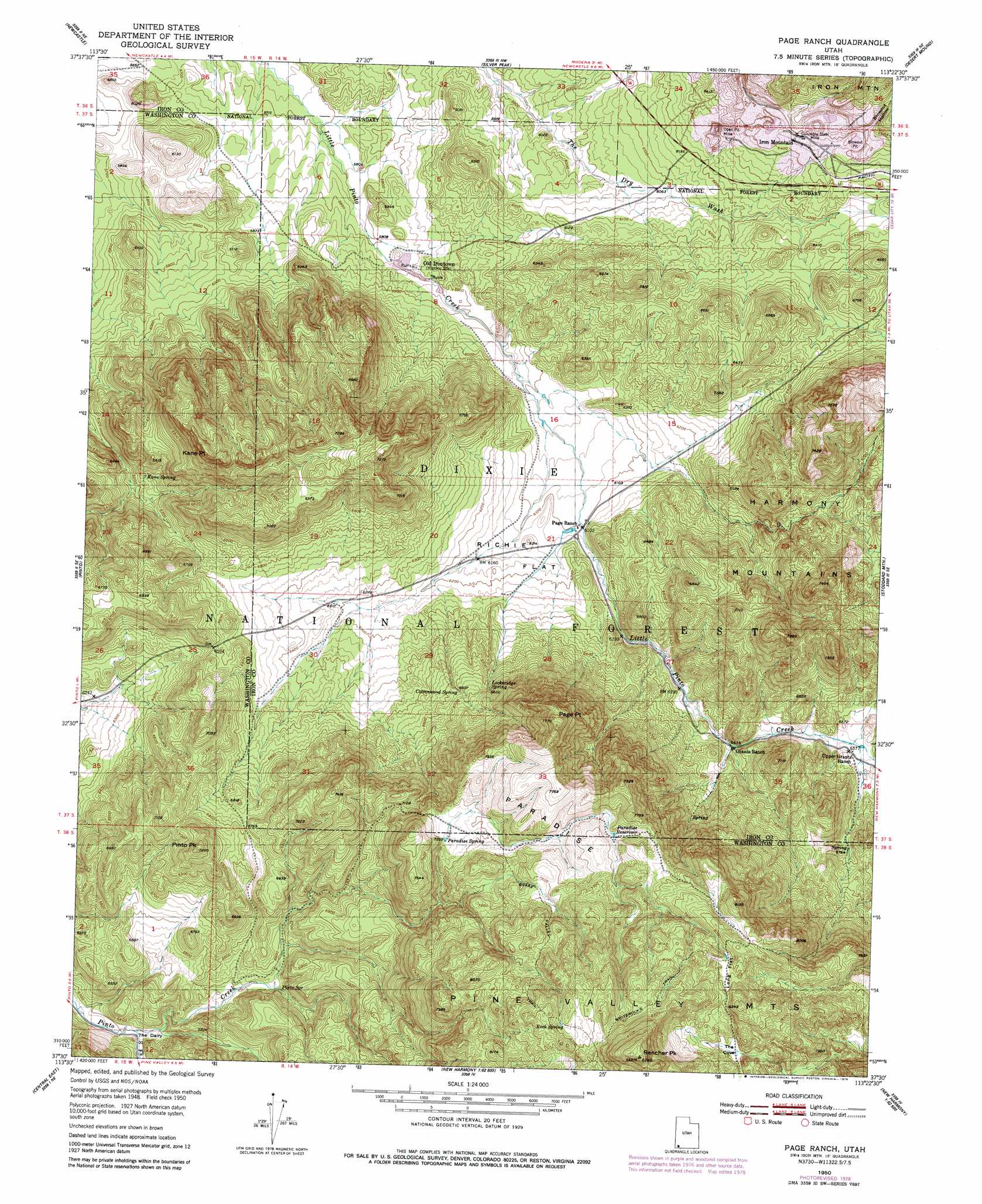
USGS Topo Quad 37113e4 - 1:24,000 scale
| Topo Map Name: | Page Ranch |
| USGS Topo Quad ID: | 37113e4 |
| Print Size: | ca. 21 1/4" wide x 27" high |
| Southeast Coordinates: | 37.5° N latitude / 113.375° W longitude |
| Map Center Coordinates: | 37.5625° N latitude / 113.4375° W longitude |
| U.S. State: | UT |
| Filename: | o37113e4.jpg |
| Download Map JPG Image: | Page Ranch topo map 1:24,000 scale |
| Map Type: | Topographic |
| Topo Series: | 7.5´ |
| Map Scale: | 1:24,000 |
| Source of Map Images: | United States Geological Survey (USGS) |
| Alternate Map Versions: |
Page Ranch UT 1950, updated 1979 Download PDF Buy paper map Page Ranch UT 1951 Download PDF Buy paper map Page Ranch UT 1951 Download PDF Buy paper map Page Ranch UT 2002, updated 2005 Download PDF Buy paper map Page Ranch UT 2011 Download PDF Buy paper map Page Ranch UT 2014 Download PDF Buy paper map |
| FStopo: | US Forest Service topo Page Ranch is available: Download FStopo PDF Download FStopo TIF |
1:24,000 Topo Quads surrounding Page Ranch
Yale Crossing |
Clark Farm |
Antelope Peak |
Avon Se |
The Three Peaks |
Beryl Junction |
Newcastle |
Silver Peak |
Desert Mound |
Cedar City Nw |
Enterprise |
Pinto |
Page Ranch |
Stoddard Mountain |
Kanarraville |
Central West |
Central East |
Grass Valley |
New Harmony |
Kolob Arch |
Veyo |
Saddle Mountain |
Signal Peak |
Pintura |
Smith Mesa |
> Back to 37113e1 at 1:100,000 scale
> Back to 37112a1 at 1:250,000 scale
> Back to U.S. Topo Maps home
Page Ranch topo map: Gazetteer
Page Ranch: Basins
Blowout Pit elevation 1975m 6479′Page Ranch: Capes
Kane Point elevation 2253m 7391′Page Ranch: Dams
Stewart Lamb Dam elevation 1765m 5790′Page Ranch: Flats
Long Flat elevation 2431m 7975′Richie Flat elevation 1882m 6174′
The Dairy elevation 1928m 6325′
Page Ranch: Mines
Colorado Mine (historical) elevation 2001m 6564′Columbia Steel Mine elevation 1966m 6450′
Page Ranch: Populated Places
Iron Mountain elevation 1969m 6459′Old Irontown elevation 1782m 5846′
Page Ranch: Reservoirs
Lamb Reservoir elevation 1765m 5790′Paradise Reservoir elevation 2298m 7539′
Page Ranch: Springs
Big Hollow Spring elevation 2075m 6807′Cottonwood Spring elevation 2012m 6601′
Gordon Spring elevation 2067m 6781′
Kane Spring elevation 1920m 6299′
Lockeridge Spring elevation 2024m 6640′
Paradise Spring elevation 2205m 7234′
Pinto Spring elevation 1994m 6541′
Rock Spring elevation 2481m 8139′
Page Ranch: Streams
South Fork Pinto Creek elevation 1925m 6315′Page Ranch: Summits
Page Point elevation 2367m 7765′Paradise elevation 2325m 7627′
Pinto Peak elevation 2203m 7227′
Rencher Peak elevation 2677m 8782′
Page Ranch: Trails
Big Hollow Trail elevation 1985m 6512′Upper Grants Ranch Trail elevation 2159m 7083′
Whiterocks Trail elevation 2488m 8162′
Page Ranch: Valleys
Blowout Hollow elevation 1996m 6548′The Cove elevation 2400m 7874′
Page Ranch digital topo map on disk
Buy this Page Ranch topo map showing relief, roads, GPS coordinates and other geographical features, as a high-resolution digital map file on DVD: