Ella Mountain Topo Map Nevada
To zoom in, hover over the map of Ella Mountain
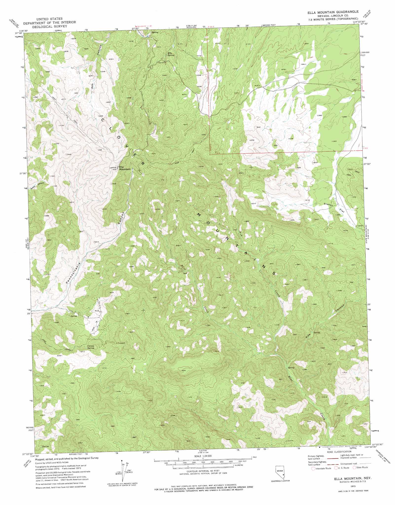
USGS Topo Quad 37114d4 - 1:24,000 scale
| Topo Map Name: | Ella Mountain |
| USGS Topo Quad ID: | 37114d4 |
| Print Size: | ca. 21 1/4" wide x 27" high |
| Southeast Coordinates: | 37.375° N latitude / 114.375° W longitude |
| Map Center Coordinates: | 37.4375° N latitude / 114.4375° W longitude |
| U.S. State: | NV |
| Filename: | o37114d4.jpg |
| Download Map JPG Image: | Ella Mountain topo map 1:24,000 scale |
| Map Type: | Topographic |
| Topo Series: | 7.5´ |
| Map Scale: | 1:24,000 |
| Source of Map Images: | United States Geological Survey (USGS) |
| Alternate Map Versions: |
Ella Mountain NV 1973, updated 1976 Download PDF Buy paper map Ella Mountain NV 2012 Download PDF Buy paper map Ella Mountain NV 2014 Download PDF Buy paper map |
1:24,000 Topo Quads surrounding Ella Mountain
Caliente Nw |
Chief Mountain |
Indian Cove |
Mosey Mountain |
Dow Mountain |
Chokecherry Mountain |
Caliente |
Eccles |
Islen |
Acoma |
Slidy Mountain |
Elgin Ne |
Ella Mountain |
Fife Mountain |
Bunker Peak |
Elgin Sw |
Elgin |
Leith |
Garden Spring |
Jacks Mountain |
Vigo Nw |
Vigo Ne |
Lyman Crossing |
Blue Nose Peak |
Lime Mountain |
> Back to 37114a1 at 1:100,000 scale
> Back to 37114a1 at 1:250,000 scale
> Back to U.S. Topo Maps home
Ella Mountain topo map: Gazetteer
Ella Mountain: Flats
Stokes Flat elevation 1808m 5931′Ella Mountain: Mines
Culverwell Mine elevation 1755m 5757′Pennsylvania Mine elevation 1760m 5774′
Ella Mountain: Reservoirs
Henrie Reservoir elevation 1865m 6118′Ella Mountain: Springs
Carson Spring elevation 1692m 5551′Elly Spring elevation 1820m 5971′
Ella Mountain: Streams
Ash Creek elevation 1466m 4809′Ella Mountain: Summits
Elly Mountain elevation 2253m 7391′Ella Mountain: Valleys
Fife Canyon elevation 1446m 4744′Ella Mountain digital topo map on disk
Buy this Ella Mountain topo map showing relief, roads, GPS coordinates and other geographical features, as a high-resolution digital map file on DVD: