Elgin Ne Topo Map Nevada
To zoom in, hover over the map of Elgin Ne
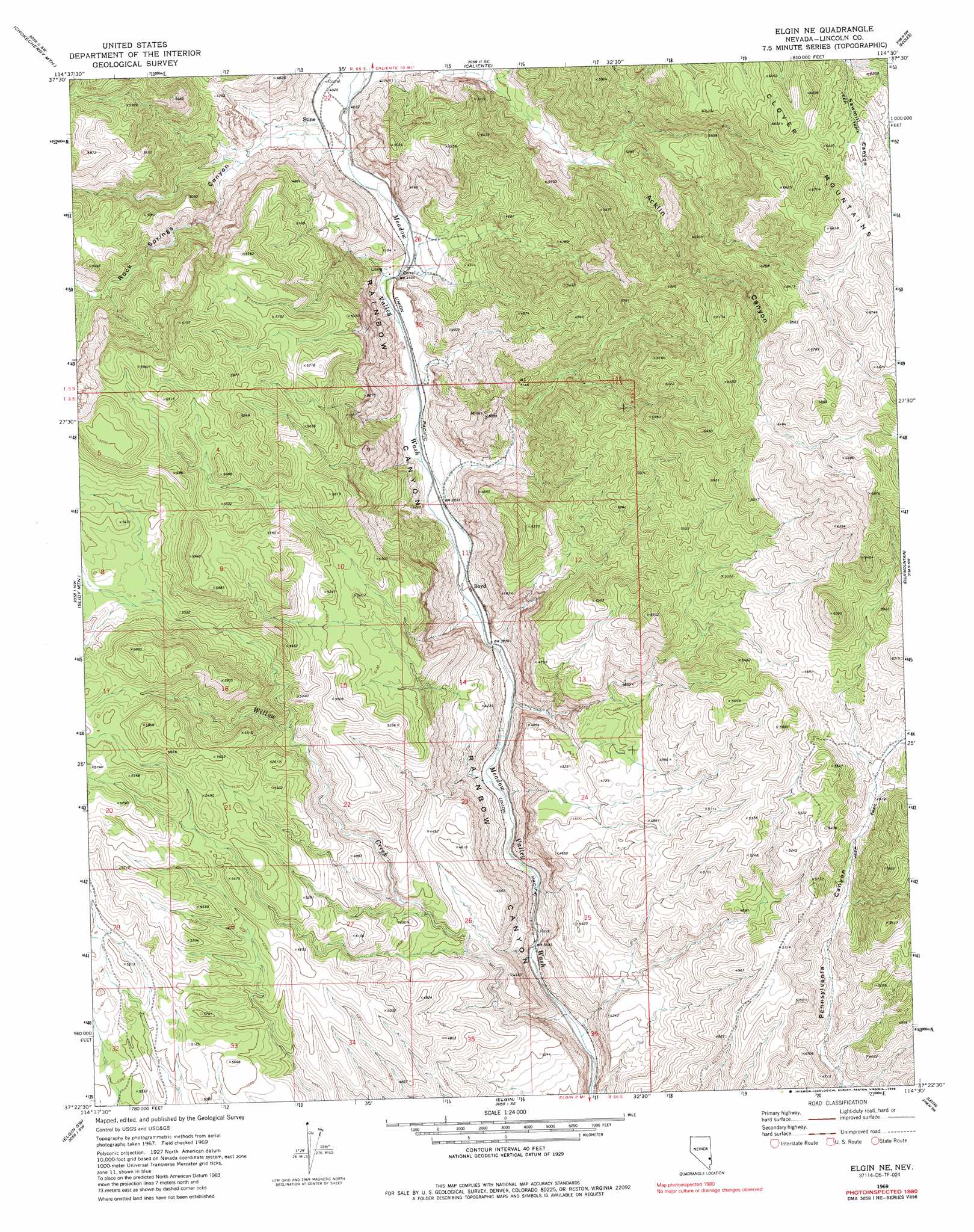
USGS Topo Quad 37114d5 - 1:24,000 scale
| Topo Map Name: | Elgin Ne |
| USGS Topo Quad ID: | 37114d5 |
| Print Size: | ca. 21 1/4" wide x 27" high |
| Southeast Coordinates: | 37.375° N latitude / 114.5° W longitude |
| Map Center Coordinates: | 37.4375° N latitude / 114.5625° W longitude |
| U.S. State: | NV |
| Filename: | o37114d5.jpg |
| Download Map JPG Image: | Elgin Ne topo map 1:24,000 scale |
| Map Type: | Topographic |
| Topo Series: | 7.5´ |
| Map Scale: | 1:24,000 |
| Source of Map Images: | United States Geological Survey (USGS) |
| Alternate Map Versions: |
Elgin NE NV 1969, updated 1973 Download PDF Buy paper map Elgin NE NV 1969, updated 1986 Download PDF Buy paper map Elgin NE NV 2012 Download PDF Buy paper map Elgin NE NV 2014 Download PDF Buy paper map |
1:24,000 Topo Quads surrounding Elgin Ne
Pahroc Spring Ne |
Caliente Nw |
Chief Mountain |
Indian Cove |
Mosey Mountain |
Pahroc Spring Se |
Chokecherry Mountain |
Caliente |
Eccles |
Islen |
Delamar |
Slidy Mountain |
Elgin Ne |
Ella Mountain |
Fife Mountain |
Gregerson Basin |
Elgin Sw |
Elgin |
Leith |
Garden Spring |
Delamar 3 Ne |
Vigo Nw |
Vigo Ne |
Lyman Crossing |
Blue Nose Peak |
> Back to 37114a1 at 1:100,000 scale
> Back to 37114a1 at 1:250,000 scale
> Back to U.S. Topo Maps home
Elgin Ne topo map: Gazetteer
Elgin Ne: Flats
Ash Flat elevation 1250m 4101′Elgin Ne: Mines
Boyd Alunite Mine elevation 1289m 4229′Boyd Clay Mine elevation 1568m 5144′
Kaolin Mine elevation 1265m 4150′
Elgin Ne: Populated Places
Boyd elevation 1165m 3822′Stine elevation 1245m 4084′
Elgin Ne: Springs
Cottonwood Springs elevation 1327m 4353′Fall Spring elevation 1699m 5574′
Flying Machine Spring elevation 1349m 4425′
Hummingbird Spring elevation 1201m 3940′
Rock Spring elevation 1365m 4478′
Whiskey Spring elevation 1329m 4360′
Elgin Ne: Streams
Willow Creek elevation 1070m 3510′Elgin Ne: Valleys
Kaolin Canyon elevation 1216m 3989′Rock Springs Canyon elevation 1241m 4071′
Whiskey Spring Canyon elevation 1216m 3989′
Willow Canyon elevation 1085m 3559′
Elgin Ne digital topo map on disk
Buy this Elgin Ne topo map showing relief, roads, GPS coordinates and other geographical features, as a high-resolution digital map file on DVD: