Pine Park Topo Map Nevada
To zoom in, hover over the map of Pine Park
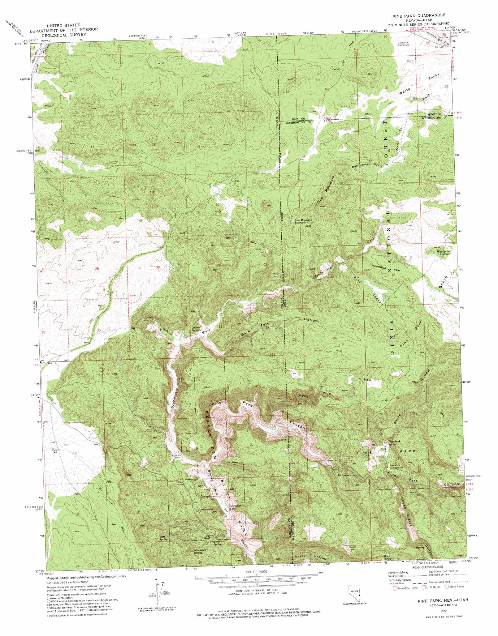
USGS Topo Quad 37114e1 - 1:24,000 scale
| Topo Map Name: | Pine Park |
| USGS Topo Quad ID: | 37114e1 |
| Print Size: | ca. 21 1/4" wide x 27" high |
| Southeast Coordinates: | 37.5° N latitude / 114° W longitude |
| Map Center Coordinates: | 37.5625° N latitude / 114.0625° W longitude |
| U.S. States: | NV, UT |
| Filename: | o37114e1.jpg |
| Download Map JPG Image: | Pine Park topo map 1:24,000 scale |
| Map Type: | Topographic |
| Topo Series: | 7.5´ |
| Map Scale: | 1:24,000 |
| Source of Map Images: | United States Geological Survey (USGS) |
| Alternate Map Versions: |
Pine Park UT 1972, updated 1975 Download PDF Buy paper map Pine Park UT 1972, updated 1975 Download PDF Buy paper map Pine Park UT 2002, updated 2005 Download PDF Buy paper map Pine Park UT 2011 Download PDF Buy paper map Pine Park UT 2014 Download PDF Buy paper map |
| FStopo: | US Forest Service topo Pine Park is available: Download FStopo PDF Download FStopo TIF |
1:24,000 Topo Quads surrounding Pine Park
Condor Canyon |
Panaca Summit |
Prohibition Flat |
Modena |
Heist |
Mosey Mountain |
Dow Mountain |
Uvada |
Mount Escalante |
Pinon Point |
Islen |
Acoma |
Pine Park |
Water Canyon Peak |
Hebron |
Fife Mountain |
Bunker Peak |
Docs Pass |
Goldstrike |
Maple Ridge |
Garden Spring |
Jacks Mountain |
Dodge Spring |
Motoqua |
Gunlock |
> Back to 37114e1 at 1:100,000 scale
> Back to 37114a1 at 1:250,000 scale
> Back to U.S. Topo Maps home
Pine Park topo map: Gazetteer
Pine Park: Dams
Schroeder Dam elevation 1563m 5127′Pine Park: Flats
Roundup Flat elevation 1868m 6128′Pine Park: Parks
Beaver Dam State Park elevation 1630m 5347′Pine Park elevation 1695m 5561′
Pine Park: Reservoirs
Crestline Reservoir elevation 1824m 5984′Pine Mountain Reservoir elevation 1880m 6167′
Schroeder Lake elevation 1563m 5127′
Wheatgrass Reservoir elevation 1884m 6181′
Pine Park: Springs
Cliff Spring elevation 1671m 5482′Grapevine Spring elevation 1552m 5091′
Mile High Spring elevation 1592m 5223′
Pine Park Spring elevation 1704m 5590′
Sheep Spring elevation 1752m 5748′
Tunnel Springs elevation 1679m 5508′
Pine Park: Streams
East Fork Beaver Dam Wash elevation 1570m 5150′Headwaters Wash elevation 1574m 5164′
Pine Park: Summits
Oak Knoll elevation 1566m 5137′Pine Mountain elevation 1990m 6528′
White Rocks elevation 1827m 5994′
Pine Park: Valleys
Barn Pole Hollow elevation 1675m 5495′California Draw elevation 1859m 6099′
Clay Canyon elevation 1767m 5797′
Headwaters Wash elevation 1567m 5141′
Pine Park Canyon elevation 1557m 5108′
Pine Park Canyon elevation 1558m 5111′
Sheep Corral Canyon elevation 1749m 5738′
Split Pine Hollow elevation 1610m 5282′
Split Pine Hollow elevation 1615m 5298′
White Hollow elevation 1679m 5508′
Pine Park digital topo map on disk
Buy this Pine Park topo map showing relief, roads, GPS coordinates and other geographical features, as a high-resolution digital map file on DVD: