Pahroc Spring Se Topo Map Nevada
To zoom in, hover over the map of Pahroc Spring Se
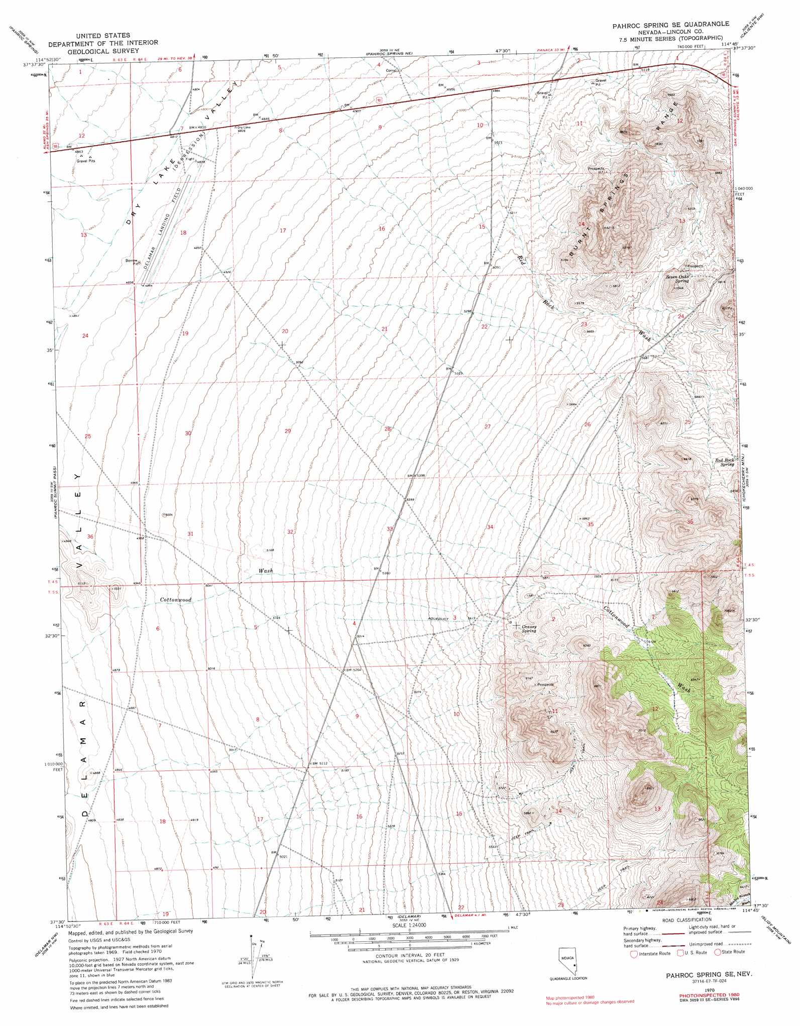
USGS Topo Quad 37114e7 - 1:24,000 scale
| Topo Map Name: | Pahroc Spring Se |
| USGS Topo Quad ID: | 37114e7 |
| Print Size: | ca. 21 1/4" wide x 27" high |
| Southeast Coordinates: | 37.5° N latitude / 114.75° W longitude |
| Map Center Coordinates: | 37.5625° N latitude / 114.8125° W longitude |
| U.S. State: | NV |
| Filename: | o37114e7.jpg |
| Download Map JPG Image: | Pahroc Spring Se topo map 1:24,000 scale |
| Map Type: | Topographic |
| Topo Series: | 7.5´ |
| Map Scale: | 1:24,000 |
| Source of Map Images: | United States Geological Survey (USGS) |
| Alternate Map Versions: |
Pahroc Spring SE NV 1970, updated 1973 Download PDF Buy paper map Pahroc Spring SE NV 1970, updated 1986 Download PDF Buy paper map Pahroc Spring SE NV 2012 Download PDF Buy paper map Pahroc Spring SE NV 2014 Download PDF Buy paper map |
1:24,000 Topo Quads surrounding Pahroc Spring Se
White River Narrows |
Wheatgrass Spring |
Deadman Spring Se |
The Bluffs |
Bennett Pass |
Hiko Ne |
Pahroc Spring |
Pahroc Spring Ne |
Caliente Nw |
Chief Mountain |
Hiko Se |
Pahroc Summit Pass |
Pahroc Spring Se |
Chokecherry Mountain |
Caliente |
Alamo Ne |
Delamar Nw |
Delamar |
Slidy Mountain |
Elgin Ne |
Alamo Se |
Delamar Lake |
Gregerson Basin |
Elgin Sw |
Elgin |
> Back to 37114e1 at 1:100,000 scale
> Back to 37114a1 at 1:250,000 scale
> Back to U.S. Topo Maps home
Pahroc Spring Se topo map: Gazetteer
Pahroc Spring Se: Airports
Caliente Flight Strip Airport elevation 1481m 4858′Pahroc Spring Se: Mines
Peggy Lee Mine elevation 1739m 5705′Pahroc Spring Se: Springs
Cottonwood Springs elevation 1499m 4917′Grassy Spring elevation 1757m 5764′
Hughie Spring elevation 1500m 4921′
Red Rock Spring elevation 1859m 6099′
Sawyer Spring elevation 1574m 5164′
Seven Oaks Spring elevation 1748m 5734′
Pahroc Spring Se: Valleys
Dry Lake Valley elevation 1476m 4842′Pahroc Spring Se digital topo map on disk
Buy this Pahroc Spring Se topo map showing relief, roads, GPS coordinates and other geographical features, as a high-resolution digital map file on DVD: