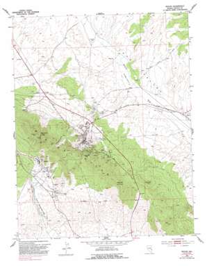
Pioche Topo Map Nevada
To zoom in, hover over the map of Pioche
USGS Topo Quad 37114h4 - 1:24,000 scale
| Topo Map Name: | Pioche |
| USGS Topo Quad ID: | 37114h4 |
| Print Size: | ca. 21 1/4" wide x 27" high |
| Southeast Coordinates: | 37.875° N latitude / 114.375° W longitude |
| Map Center Coordinates: | 37.9375° N latitude / 114.4375° W longitude |
| U.S. State: | NV |
| Filename: | o37114h4.jpg |
| Download Map JPG Image: | Pioche topo map 1:24,000 scale |
| Map Type: | Topographic |
| Topo Series: | 7.5´ |
| Map Scale: | 1:24,000 |
| Source of Map Images: | United States Geological Survey (USGS) |
| Alternate Map Versions: |
Pioche NV 1953, updated 1955 Download PDF Buy paper map Pioche NV 1953, updated 1971 Download PDF Buy paper map Pioche NV 1953, updated 1990 Download PDF Buy paper map Pioche NV 1953, updated 1993 Download PDF Buy paper map Pioche NV 2012 Download PDF Buy paper map Pioche NV 2014 Download PDF Buy paper map |
1:24,000 Topo Quads surrounding Pioche
> Back to 37114e1 at 1:100,000 scale
> Back to 37114a1 at 1:250,000 scale
> Back to U.S. Topo Maps home
Pioche topo map: Gazetteer
Pioche: Dams
Caselton Pond Number 10 Dam elevation 1718m 5636′Caselton Pond Number 4 Dam elevation 1769m 5803′
Caselton Pond Number 5 Dam elevation 1760m 5774′
Caselton Pond Number 8 Dam elevation 1747m 5731′
Caselton Pond Number 9 Dam elevation 1739m 5705′
Caselton Recreation Area Last Pond Dam elevation 1728m 5669′
Pioche: Mines
Abe Lincoln Mine elevation 2053m 6735′Acme Mine elevation 1783m 5849′
Alps Mine elevation 2035m 6676′
Amalgamated Pioche Mine elevation 1855m 6085′
American Flag Mine elevation 2035m 6676′
Arkansas Mine elevation 2035m 6676′
Blue Bell Mine elevation 1845m 6053′
Boston Pioche Mine elevation 1975m 6479′
Bowery Shaft elevation 1852m 6076′
Bud Rudy Mine elevation 1925m 6315′
Burke Mine elevation 2035m 6676′
California Pioche Mine elevation 1931m 6335′
Caselton Shaft elevation 1925m 6315′
Centennial Shaft elevation 1777m 5830′
Chapman Mine elevation 2035m 6676′
Chicago Nevada Mine elevation 1986m 6515′
Chief of the Hill Mine elevation 2035m 6676′
Chisholm Mine elevation 2141m 7024′
Chope Mine elevation 1803m 5915′
Cottino Mine elevation 1986m 6515′
Daily East Shaft elevation 1941m 6368′
Doris Group Mine elevation 1925m 6315′
Ely Valley Contact Mine elevation 1918m 6292′
Ely Valley Mines elevation 1885m 6184′
Excelsior Mine elevation 2035m 6676′
Garrison Mine elevation 1918m 6292′
Gold and Silver Prince Mine elevation 1925m 6315′
Golden Eagle Shaft elevation 1803m 5915′
Golden Prince Mine elevation 1925m 6315′
Half Moon Mine elevation 2040m 6692′
Hermes Mine elevation 2035m 6676′
Homestake Tunnel elevation 1911m 6269′
Huhn and Hunt Mine elevation 2035m 6676′
Ingomer Mine elevation 2035m 6676′
Ivanhoe Mine elevation 2035m 6676′
Kentucky Mine elevation 2035m 6676′
Lightner Shaft elevation 2035m 6676′
Lincoln Nevada Mine elevation 1975m 6479′
Meadow Valley Shaft Three elevation 2035m 6676′
Meadow Valley Summit Shaft elevation 2035m 6676′
Missouri Prince Mine elevation 1925m 6315′
Nevada Desmoins Mine elevation 1855m 6085′
Nevada Utah Mine elevation 2001m 6564′
Newark Mine elevation 2035m 6676′
North Pole Tunnel elevation 1937m 6354′
Number Fifteen Shaft elevation 1912m 6272′
Number One Shaft elevation 1855m 6085′
Number Three Shaft elevation 1855m 6085′
Ohio Kentucky Mine elevation 1855m 6085′
Ohio Kentucky Mine elevation 1931m 6335′
Old Panacca Mine elevation 2035m 6676′
Pacific Tunnel elevation 1885m 6184′
Page and Panacca Mine elevation 2035m 6676′
Pioche Champion Mine elevation 2035m 6676′
Pioche Consolidated Mine elevation 1975m 6479′
Pioche Demijohn Mine elevation 2001m 6564′
Pioche Gold Crown Mine elevation 1901m 6236′
Pioche King Mine elevation 1793m 5882′
Pioche Mine elevation 2035m 6676′
Pioche Mohawk Mine elevation 1975m 6479′
Pioche Pacific Mine elevation 1931m 6335′
Pioche Phenix Mine elevation 2035m 6676′
Pioche Western Extension Mine elevation 2035m 6676′
Poorman Mine elevation 1835m 6020′
Portland Pioche Mine elevation 1783m 5849′
Prince Extension Mine elevation 1803m 5915′
Prince Mine elevation 1784m 5853′
Raymond and Ely Mine elevation 2035m 6676′
Raymond Ely Extension Mine elevation 1797m 5895′
Raymond Ely West Mine elevation 1986m 6515′
Rhonado Mine elevation 1931m 6335′
Rustic Mine elevation 1918m 6292′
Salt Lake Pioche Mine elevation 1975m 6479′
Scott Mine elevation 1975m 6479′
Springtime Tunnel elevation 2014m 6607′
Sun Moon Mine elevation 1931m 6335′
Timer Mine elevation 2001m 6564′
Tollock Doll Mine elevation 1918m 6292′
Treasure Hill Mine elevation 1925m 6315′
Virginia Louise Mine elevation 1803m 5915′
Volcano Mine elevation 1879m 6164′
Washington and Creole Mine elevation 2035m 6676′
Wide Awake Shaft elevation 1975m 6479′
Pioche: Parks
Caselton Recreational Area elevation 1748m 5734′Pioche: Populated Places
Caselton elevation 1893m 6210′Caselton Heights elevation 1847m 6059′
Pioche elevation 1855m 6085′
Prince elevation 1776m 5826′
Princeton (historical) elevation 1755m 5757′
Pioche: Post Offices
Pioche Post Office elevation 1849m 6066′Princeton Post Office (historical) elevation 1755m 5757′
Pioche: Ranges
Pioche Hills elevation 2035m 6676′Pioche: Reservoirs
Upper Patterson Reservoir elevation 1678m 5505′Pioche: Ridges
Step Ridge elevation 2066m 6778′Pioche: Summits
Gray Cone elevation 1908m 6259′Lime Hill elevation 1908m 6259′
Mount Ely elevation 2223m 7293′
Red Hill elevation 2015m 6610′
Treasure Hill elevation 2066m 6778′
Williams Hill elevation 2051m 6729′
Pioche: Valleys
Churndrill Canyon elevation 1860m 6102′Lake Valley elevation 1666m 5465′
Slaughterhouse Canyon elevation 1848m 6062′
Pioche: Wells
Fourmile Well elevation 1683m 5521′Pioche digital topo map on disk
Buy this Pioche topo map showing relief, roads, GPS coordinates and other geographical features, as a high-resolution digital map file on DVD:


