Lower Pahranagat Lake Topo Map Nevada
To zoom in, hover over the map of Lower Pahranagat Lake
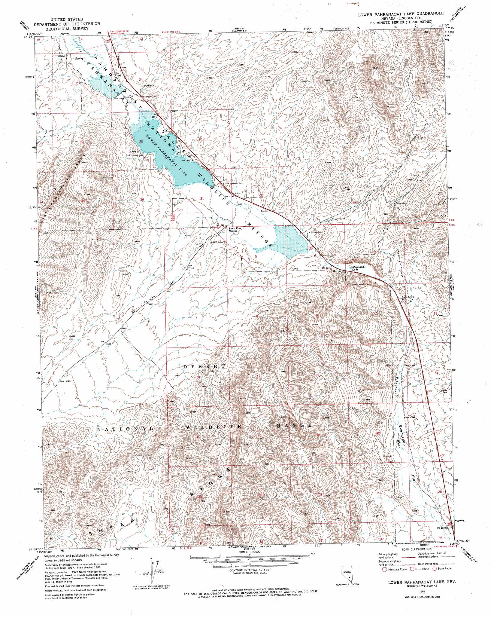
USGS Topo Quad 37115b1 - 1:24,000 scale
| Topo Map Name: | Lower Pahranagat Lake |
| USGS Topo Quad ID: | 37115b1 |
| Print Size: | ca. 21 1/4" wide x 27" high |
| Southeast Coordinates: | 37.125° N latitude / 115° W longitude |
| Map Center Coordinates: | 37.1875° N latitude / 115.0625° W longitude |
| U.S. State: | NV |
| Filename: | o37115b1.jpg |
| Download Map JPG Image: | Lower Pahranagat Lake topo map 1:24,000 scale |
| Map Type: | Topographic |
| Topo Series: | 7.5´ |
| Map Scale: | 1:24,000 |
| Source of Map Images: | United States Geological Survey (USGS) |
| Alternate Map Versions: |
Lower Pahranagat Lake NV 1969, updated 1973 Download PDF Buy paper map Lower Pahranagat Lake NV 2012 Download PDF Buy paper map Lower Pahranagat Lake NV 2015 Download PDF Buy paper map |
1:24,000 Topo Quads surrounding Lower Pahranagat Lake
Hancock Summit |
Ash Springs |
Alamo Ne |
Delamar Nw |
Delamar |
Badger Spring |
Alamo |
Alamo Se |
Delamar Lake |
Gregerson Basin |
Desert Hills Ne |
Lower Pahranagat Lake Nw |
Lower Pahranagat Lake |
Delamar 3 Nw |
Delamar 3 Ne |
Desert Hills Se |
Lower Pahranagat Lake Sw |
Lower Pahranagat Lake Se |
Delamar 3 Sw |
Delamar 3 Se |
Burro Basin |
Mule Deer Ridge Nw |
Mule Deer Ridge Ne |
Wildcat Wash Nw |
Wildcat Wash Ne |
> Back to 37115a1 at 1:100,000 scale
> Back to 37114a1 at 1:250,000 scale
> Back to U.S. Topo Maps home
Lower Pahranagat Lake topo map: Gazetteer
Lower Pahranagat Lake: Flats
Evergreen Flat elevation 888m 2913′Lower Pahranagat Lake: Lakes
Lower Pahranagat Lake elevation 973m 3192′Maynard Lake elevation 952m 3123′
Lower Pahranagat Lake: Parks
Pahranagat National Wildlife Refuge elevation 975m 3198′Lower Pahranagat Lake: Reservoirs
Middle Pond elevation 981m 3218′Lower Pahranagat Lake: Springs
Big Spring elevation 962m 3156′Evergreen Spring elevation 1219m 3999′
Hoyt Spring elevation 976m 3202′
Lone Tree Spring elevation 976m 3202′
Lower Pahranagat Lake: Valleys
Pahranagat Valley elevation 959m 3146′Lower Pahranagat Lake digital topo map on disk
Buy this Lower Pahranagat Lake topo map showing relief, roads, GPS coordinates and other geographical features, as a high-resolution digital map file on DVD: