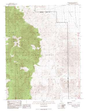
Groom Range Topo Map Nevada
To zoom in, hover over the map of Groom Range
USGS Topo Quad 37115d6 - 1:24,000 scale
| Topo Map Name: | Groom Range |
| USGS Topo Quad ID: | 37115d6 |
| Print Size: | ca. 21 1/4" wide x 27" high |
| Southeast Coordinates: | 37.375° N latitude / 115.625° W longitude |
| Map Center Coordinates: | 37.4375° N latitude / 115.6875° W longitude |
| U.S. State: | NV |
| Filename: | o37115d6.jpg |
| Download Map JPG Image: | Groom Range topo map 1:24,000 scale |
| Map Type: | Topographic |
| Topo Series: | 7.5´ |
| Map Scale: | 1:24,000 |
| Source of Map Images: | United States Geological Survey (USGS) |
| Alternate Map Versions: |
Groom Range NV 1989, updated 1989 Download PDF Buy paper map |
1:24,000 Topo Quads surrounding Groom Range
> Back to 37115a1 at 1:100,000 scale
> Back to 37114a1 at 1:250,000 scale
> Back to U.S. Topo Maps home
Groom Range topo map: Gazetteer
Groom Range: Populated Places
Groom (historical) elevation 1841m 6040′Groom Range: Ranges
Groom Range elevation 2819m 9248′Tikaboo Range elevation 1785m 5856′
Groom Range: Springs
Alum Spring elevation 1805m 5921′Lick Spring elevation 1814m 5951′
Naquinta Spring elevation 2288m 7506′
Quail Spring elevation 1952m 6404′
Rabbit Brush Spring elevation 1876m 6154′
Rock Spring elevation 1786m 5859′
Sabio Spring elevation 1775m 5823′
Savot Spring elevation 2089m 6853′
Groom Range: Summits
Bald Mountain elevation 2819m 9248′Mount Wandell elevation 2397m 7864′
Groom Range digital topo map on disk
Buy this Groom Range topo map showing relief, roads, GPS coordinates and other geographical features, as a high-resolution digital map file on DVD:


