Mud Lake Nw Topo Map Nevada
To zoom in, hover over the map of Mud Lake Nw
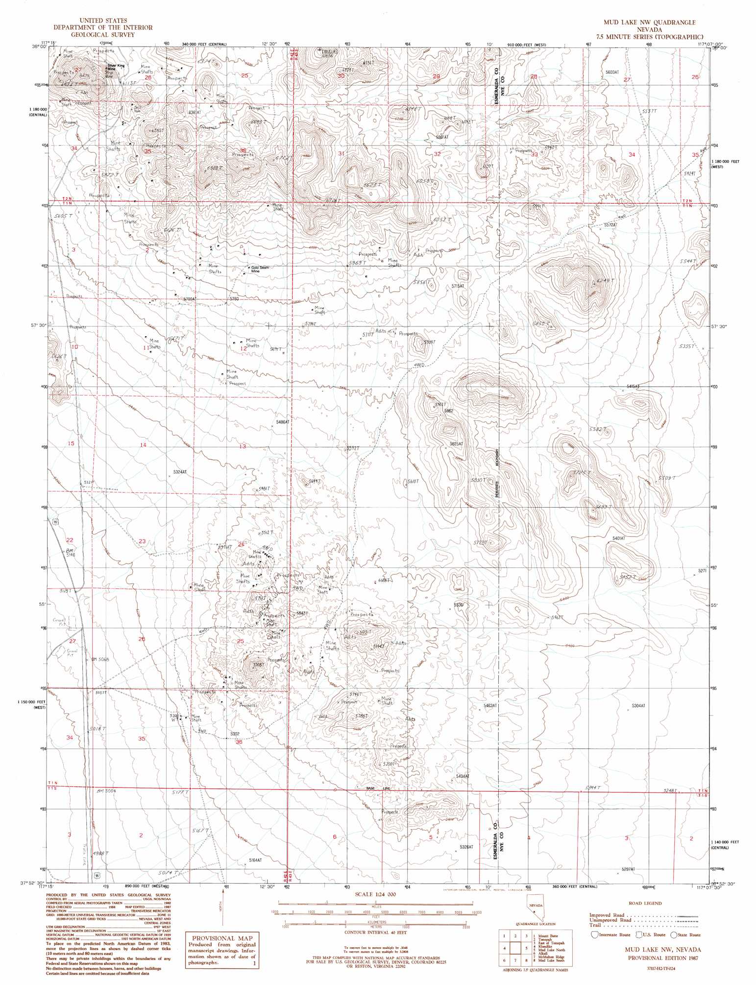
USGS Topo Quad 37117h2 - 1:24,000 scale
| Topo Map Name: | Mud Lake Nw |
| USGS Topo Quad ID: | 37117h2 |
| Print Size: | ca. 21 1/4" wide x 27" high |
| Southeast Coordinates: | 37.875° N latitude / 117.125° W longitude |
| Map Center Coordinates: | 37.9375° N latitude / 117.1875° W longitude |
| U.S. State: | NV |
| Filename: | o37117h2.jpg |
| Download Map JPG Image: | Mud Lake Nw topo map 1:24,000 scale |
| Map Type: | Topographic |
| Topo Series: | 7.5´ |
| Map Scale: | 1:24,000 |
| Source of Map Images: | United States Geological Survey (USGS) |
| Alternate Map Versions: |
Mud Lake NW NV 1987, updated 1988 Download PDF Buy paper map Mud Lake NW NV 2011 Download PDF Buy paper map Mud Lake NW NV 2014 Download PDF Buy paper map |
1:24,000 Topo Quads surrounding Mud Lake Nw
Millers |
Crescent Dunes |
Rays |
Thumder Mountain |
Hannapah |
Lone Mountain |
Mount Butte |
Tonopah |
East Of Tonopah |
Mckinney Tanks |
Paymaster Canyon |
Klondike |
Mud Lake Nw |
Mud Lake North |
Monitor Peak |
Paymaster Ridge |
Alkali |
Mcmahon Ridge |
Mud Lake South |
Cactus Peak |
Split Mountain |
Montezuma Peak |
Goldfield |
East Of Goldfield |
White Patch Draw |
> Back to 37117e1 at 1:100,000 scale
> Back to 37116a1 at 1:250,000 scale
> Back to U.S. Topo Maps home
Mud Lake Nw topo map: Gazetteer
Mud Lake Nw: Gaps
Divide elevation 1861m 6105′Mud Lake Nw: Mines
Allied Divine Mine elevation 1831m 6007′Alto Divide Mine elevation 1831m 6007′
Apex Divide Mine elevation 1831m 6007′
Argentine Divide Mine elevation 1831m 6007′
Brougher Divide Mine elevation 1831m 6007′
Calumet Divide Mine elevation 1831m 6007′
Crown Divide Mine elevation 1831m 6007′
Divide City Mine elevation 1831m 6007′
Divide Consolidated Mine elevation 1831m 6007′
Divide Extension Mine elevation 1831m 6007′
Divide Junior Mine elevation 1831m 6007′
Doctor Divide Mine elevation 1831m 6007′
East Divide Mine elevation 1831m 6007′
Florence Divide Mine elevation 1831m 6007′
Giant Divide Mine elevation 1831m 6007′
Gold Reef Divide Mine elevation 1831m 6007′
Gold Seam Mine elevation 1791m 5875′
Gold Zone Mine elevation 1831m 6007′
Golden State Divide Mine elevation 1831m 6007′
Great Dane Mine elevation 1831m 6007′
Grimes Divide Mine elevation 1831m 6007′
Harmell Divide Mine elevation 1831m 6007′
Hasbrouck Mine elevation 1831m 6007′
Hennessy Divide Mine elevation 1831m 6007′
High Divide Mine elevation 1831m 6007′
Horseshoe Divide Mine elevation 1831m 6007′
Hull Canyon Mine elevation 1831m 6007′
Independence Mine elevation 1831m 6007′
Jims Divide Mine elevation 1831m 6007′
Knox Divide Mine elevation 1831m 6007′
Midway Divide Mine elevation 1831m 6007′
Mohawk Divide Mine elevation 1831m 6007′
North Divide Mine elevation 1831m 6007′
Reno Divide Mine elevation 1831m 6007′
Reorganized Silver King Mine elevation 1831m 6007′
Revert Mine elevation 1831m 6007′
Silver Divide Mine elevation 1831m 6007′
Silver King Mine elevation 1821m 5974′
Silver King Mine elevation 1732m 5682′
Silver Mines Corporation Mine elevation 1831m 6007′
Silver Zone Mine elevation 1737m 5698′
Smith Turquoise Mine elevation 1637m 5370′
Smuggler Divide Mine elevation 1831m 6007′
Sutherland Divide Mine elevation 1831m 6007′
Toggery Divide Mine elevation 1831m 6007′
Tonopah Divide Mine elevation 1831m 6007′
Tonopah Dividend Mine elevation 1831m 6007′
Verdi Divide Mine elevation 1831m 6007′
Victory Mine elevation 1831m 6007′
Wilson Divide Mine elevation 1831m 6007′
Mud Lake Nw: Populated Places
Gold Reef (historical) elevation 1788m 5866′Southern Klondike (historical) elevation 1695m 5561′
Mud Lake Nw: Springs
Gold Reef Spring elevation 1830m 6003′Mud Lake Nw: Summits
Gold Mountain elevation 2023m 6637′Klondyke Hills elevation 1892m 6207′
Southern Klondyke Hills elevation 1834m 6017′
Mud Lake Nw digital topo map on disk
Buy this Mud Lake Nw topo map showing relief, roads, GPS coordinates and other geographical features, as a high-resolution digital map file on DVD: