Mount Thompson Topo Map California
To zoom in, hover over the map of Mount Thompson
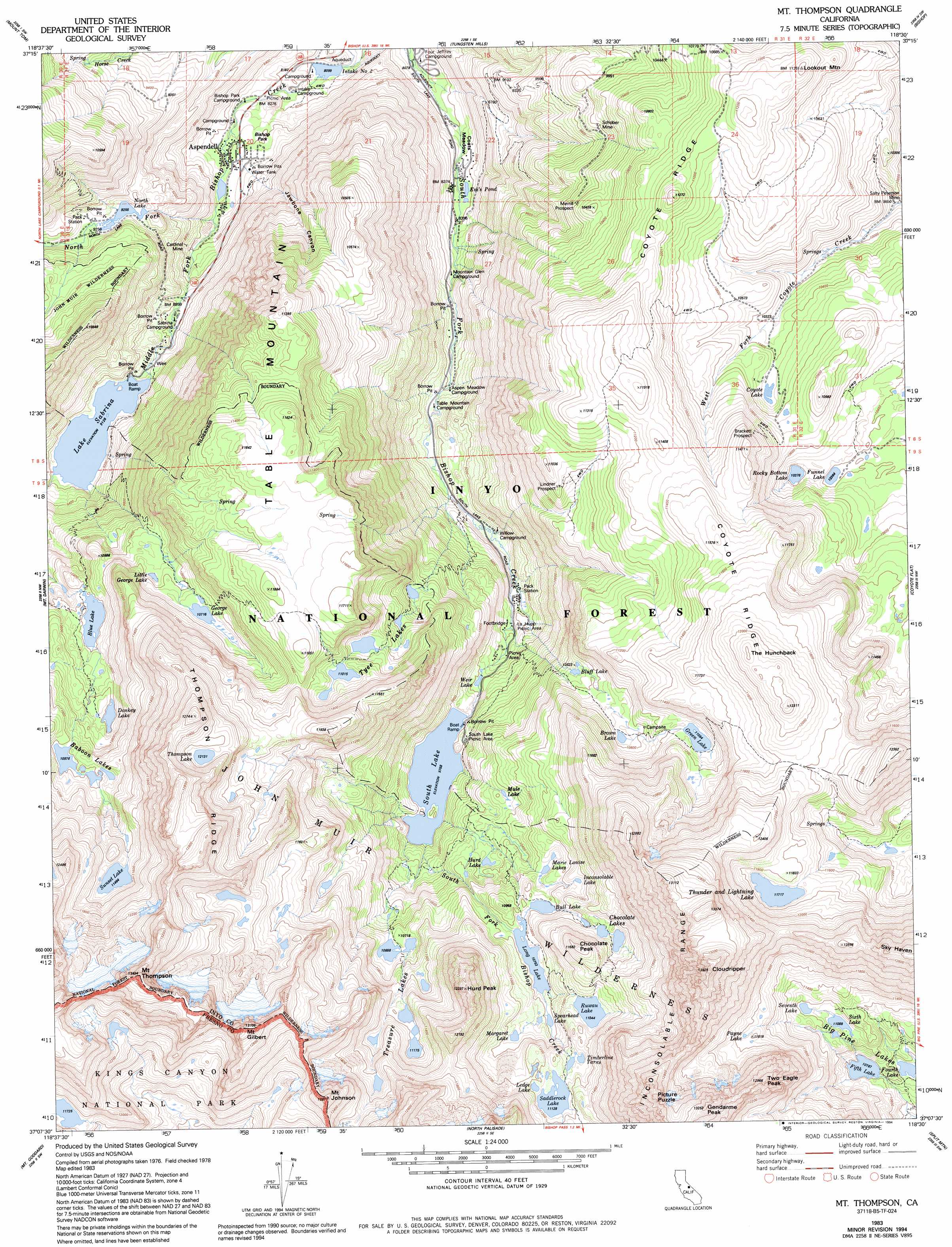
USGS Topo Quad 37118b5 - 1:24,000 scale
| Topo Map Name: | Mount Thompson |
| USGS Topo Quad ID: | 37118b5 |
| Print Size: | ca. 21 1/4" wide x 27" high |
| Southeast Coordinates: | 37.125° N latitude / 118.5° W longitude |
| Map Center Coordinates: | 37.1875° N latitude / 118.5625° W longitude |
| U.S. State: | CA |
| Filename: | o37118b5.jpg |
| Download Map JPG Image: | Mount Thompson topo map 1:24,000 scale |
| Map Type: | Topographic |
| Topo Series: | 7.5´ |
| Map Scale: | 1:24,000 |
| Source of Map Images: | United States Geological Survey (USGS) |
| Alternate Map Versions: |
Mt. Thompson CA 1983, updated 1983 Download PDF Buy paper map Mt. Thompson CA 1983, updated 1988 Download PDF Buy paper map Mt. Thompson CA 1983, updated 1994 Download PDF Buy paper map Mt. Thompson CA 1983, updated 1994 Download PDF Buy paper map Mt. Thompson CA 1994, updated 1997 Download PDF Buy paper map Mount Thompson CA 2012 Download PDF Buy paper map Mount Thompson CA 2015 Download PDF Buy paper map |
| FStopo: | US Forest Service topo Mount Thompson is available: Download FStopo PDF Download FStopo TIF |
1:24,000 Topo Quads surrounding Mount Thompson
Mount Abbot |
Mount Morgan |
Rovana |
Fish Slough |
Laws |
Mount Hilgard |
Mount Tom |
Tungsten Hills |
Bishop |
Poleta Canyon |
Mount Henry |
Mount Darwin |
Mount Thompson |
Coyote Flat |
Big Pine |
Blackcap Mountain |
Mount Goddard |
North Palisade |
Split Mountain |
Fish Springs |
Tehipite Dome |
Slide Bluffs |
Marion Peak |
Mount Pinchot |
Aberdeen |
> Back to 37118a1 at 1:100,000 scale
> Back to 37118a1 at 1:250,000 scale
> Back to U.S. Topo Maps home
Mount Thompson topo map: Gazetteer
Mount Thompson: Dams
Bishop Creek 104-033 Dam elevation 2474m 8116′Hillside 104-030 Dam elevation 2962m 9717′
North Lake 104-036 Dam elevation 2824m 9265′
Sabrina 104-032 Dam elevation 2784m 9133′
Mount Thompson: Flats
Bishop Park elevation 2510m 8234′Coats Meadow elevation 2544m 8346′
Mount Thompson: Lakes
Baboon Lakes elevation 3364m 11036′Big Pine Lakes elevation 3290m 10793′
Blue Lake elevation 3168m 10393′
Bluff Lake elevation 3208m 10524′
Brown Lake elevation 3279m 10757′
Chocolate Lakes elevation 3377m 11079′
Coyote Lake elevation 3182m 10439′
Donkey Lake elevation 3229m 10593′
Ems Pond elevation 2554m 8379′
Fifth Lake elevation 3290m 10793′
Fourth Lake elevation 3277m 10751′
Funnel Lake elevation 3161m 10370′
George Lake elevation 3268m 10721′
Green Lake elevation 3372m 11062′
Hurd Lake elevation 3143m 10311′
Inconsolable Lake elevation 3326m 10912′
Lake Sabrina elevation 2784m 9133′
Ledge Lake elevation 3412m 11194′
Little George Lake elevation 3206m 10518′
Long Lake elevation 3279m 10757′
Margaret Lake elevation 3354m 11003′
Marie Louise Lakes elevation 3239m 10626′
Mule Lake elevation 3157m 10357′
Rocky Bottom Lake elevation 3164m 10380′
Ruwau Lake elevation 3368m 11049′
Saddlerock Lake elevation 3394m 11135′
Seventh Lake elevation 3414m 11200′
Sixth Lake elevation 3381m 11092′
Spearhead Lake elevation 3302m 10833′
Summit Lake elevation 3341m 10961′
Sunset Lake elevation 3496m 11469′
Thompson Lake elevation 3706m 12158′
Thunder and Lightning Lake elevation 3573m 11722′
Timberline Tarns elevation 3379m 11085′
Treasure Lakes elevation 3397m 11145′
Tyee Lakes elevation 3325m 10908′
Weir Lake elevation 2926m 9599′
Mount Thompson: Mines
Bishop Prospect elevation 3334m 10938′Brackett Prospect elevation 3333m 10935′
Cardinal Mine elevation 2636m 8648′
Lindner Prospect elevation 3306m 10846′
Merrill Prospect elevation 3111m 10206′
Salty Peterson Mine elevation 3026m 9927′
Schober Mine elevation 3055m 10022′
Stevens Prospect elevation 2608m 8556′
Waterfall Prospect elevation 2683m 8802′
Mount Thompson: Populated Places
Aspendell elevation 2563m 8408′Mount Thompson: Reservoirs
North Lake elevation 2824m 9265′South Lake elevation 2962m 9717′
Mount Thompson: Ridges
Coyote Ridge elevation 3746m 12290′Inconsolable Range elevation 3850m 12631′
Thompson Ridge elevation 3920m 12860′
Mount Thompson: Streams
Lamarck Creek elevation 2830m 9284′North Fork Lamarck Creek elevation 2830m 9284′
Mount Thompson: Summits
Chocolate Peak elevation 3510m 11515′Cloudripper elevation 4101m 13454′
Gendarme Peak elevation 4027m 13211′
Hurd Peak elevation 3713m 12181′
Lookout Mountain elevation 3401m 11158′
Mount Gilbert elevation 3947m 12949′
Mount Johnson elevation 3898m 12788′
Mount Thompson elevation 4115m 13500′
Picture Puzzle elevation 4041m 13257′
Sky Haven elevation 3916m 12847′
Table Mountain elevation 3563m 11689′
The Hunchback elevation 3694m 12119′
Two Eagle Peak elevation 3956m 12979′
Mount Thompson: Valleys
Jawbone Canyon elevation 2549m 8362′Mount Thompson digital topo map on disk
Buy this Mount Thompson topo map showing relief, roads, GPS coordinates and other geographical features, as a high-resolution digital map file on DVD: