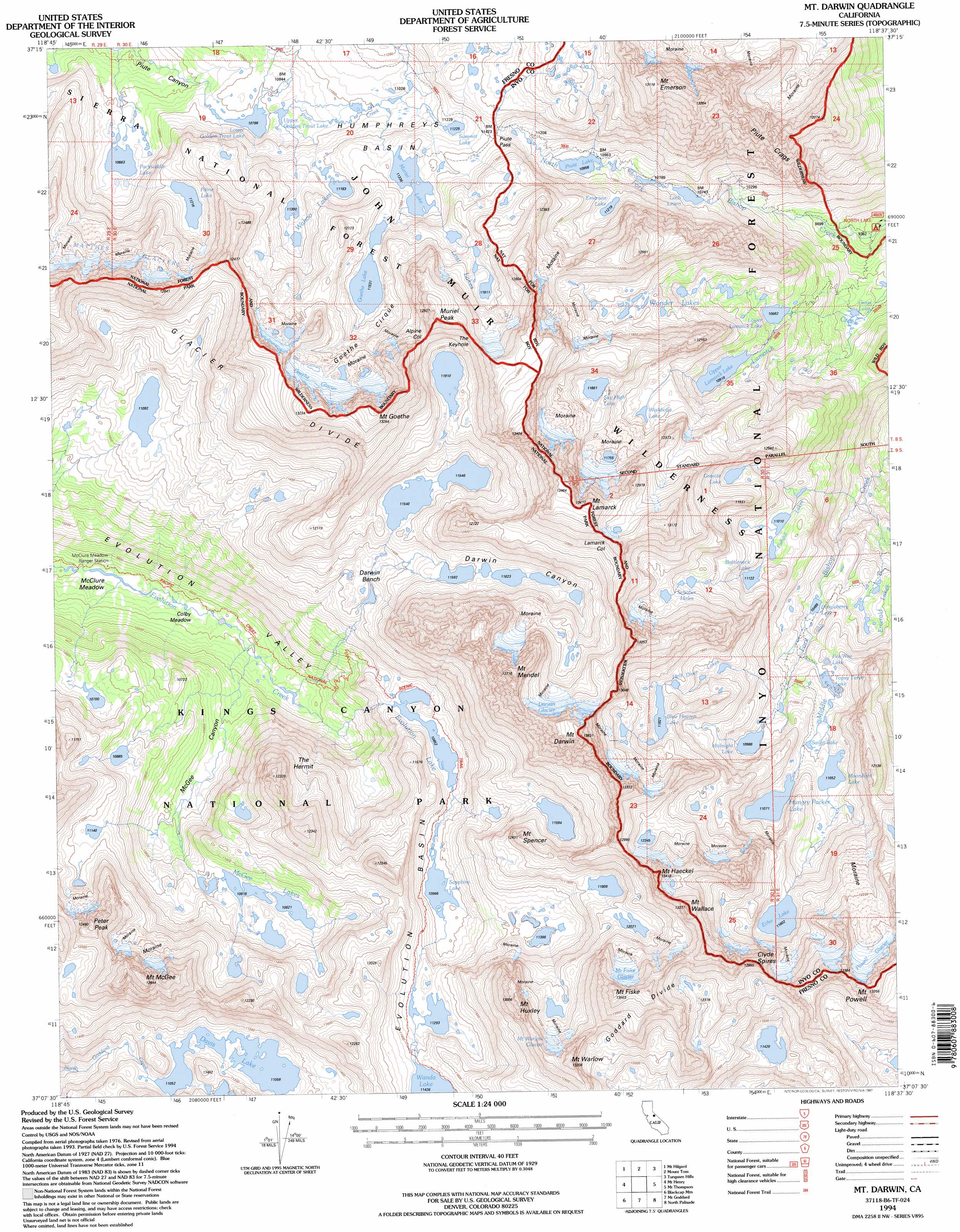
Mount Darwin Topo Map California
To zoom in, hover over the map of Mount Darwin
USGS Topo Quad 37118b6 - 1:24,000 scale
| Topo Map Name: | Mount Darwin |
| USGS Topo Quad ID: | 37118b6 |
| Print Size: | ca. 21 1/4" wide x 27" high |
| Southeast Coordinates: | 37.125° N latitude / 118.625° W longitude |
| Map Center Coordinates: | 37.1875° N latitude / 118.6875° W longitude |
| U.S. State: | CA |
| Filename: | o37118b6.jpg |
| Download Map JPG Image: | Mount Darwin topo map 1:24,000 scale |
| Map Type: | Topographic |
| Topo Series: | 7.5´ |
| Map Scale: | 1:24,000 |
| Source of Map Images: | United States Geological Survey (USGS) |
| Alternate Map Versions: |
Mt. Darwin CA 1983, updated 1983 Download PDF Buy paper map Mt. Darwin CA 1983, updated 1985 Download PDF Buy paper map Mt. Darwin CA 1983, updated 1994 Download PDF Buy paper map Mt. Darwin CA 1994, updated 1997 Download PDF Buy paper map Mount Darwin CA 2012 Download PDF Buy paper map Mount Darwin CA 2015 Download PDF Buy paper map |
| FStopo: | US Forest Service topo Mount Darwin is available: Download FStopo PDF Download FStopo TIF |
1:24,000 Topo Quads surrounding Mount Darwin
Graveyard Peak |
Mount Abbot |
Mount Morgan |
Rovana |
Fish Slough |
Florence Lake |
Mount Hilgard |
Mount Tom |
Tungsten Hills |
Bishop |
Ward Mountain |
Mount Henry |
Mount Darwin |
Mount Thompson |
Coyote Flat |
Courtright Reservoir |
Blackcap Mountain |
Mount Goddard |
North Palisade |
Split Mountain |
Rough Spur |
Tehipite Dome |
Slide Bluffs |
Marion Peak |
Mount Pinchot |
> Back to 37118a1 at 1:100,000 scale
> Back to 37118a1 at 1:250,000 scale
> Back to U.S. Topo Maps home
Mount Darwin topo map: Gazetteer
Mount Darwin: Basins
Evolution Basin elevation 3446m 11305′Goethe Cirque elevation 3580m 11745′
Mount Darwin: Benches
Darwin Bench elevation 3439m 11282′Mount Darwin: Flats
Colby Meadow elevation 2987m 9799′McClure Meadow elevation 2933m 9622′
Mount Darwin: Gaps
Alpine Col elevation 3713m 12181′Lamarck Col elevation 3928m 12887′
Piute Pass elevation 3480m 11417′
The Keyhole elevation 3805m 12483′
Mount Darwin: Glaciers
Darwin Glacier elevation 3871m 12700′Goethe Glacier elevation 3745m 12286′
Mount Fiske Glacier elevation 3828m 12559′
Mount Warlow Glacier elevation 3754m 12316′
Powell Glacier elevation 3817m 12522′
Mount Darwin: Lakes
Blue Heaven Lake elevation 3605m 11827′Bottleneck Lake elevation 3392m 11128′
Davis Lake elevation 3372m 11062′
Dingleberry Lake elevation 3199m 10495′
Echo Lake elevation 3538m 11607′
Emerald Lakes elevation 3194m 10479′
Emerson Lake elevation 3421m 11223′
Evolution Lake elevation 3310m 10859′
Fishgut Lakes elevation 3358m 11017′
Goethe Lake elevation 3517m 11538′
Granite Lake elevation 3509m 11512′
Grass Lake elevation 3010m 9875′
Hell Diver Lakes elevation 3495m 11466′
Hungry Packer Lake elevation 3376m 11076′
Loch Leven elevation 3276m 10748′
Lost Lakes elevation 3630m 11909′
Lower Golden Trout Lake elevation 3289m 10790′
Lower Lamarck Lake elevation 3252m 10669′
McGee Lake elevation 3300m 10826′
Midnight Lake elevation 3351m 10994′
Moonlight Lake elevation 3371m 11059′
Muriel Lake elevation 3457m 11341′
Packsaddle Lake elevation 3252m 10669′
Payne Lake elevation 3420m 11220′
Pee Wee Lake elevation 3292m 10800′
Piute Lake elevation 3342m 10964′
Sailor Lake elevation 3348m 10984′
Sapphire Lake elevation 3344m 10971′
Schober Lakes elevation 3572m 11719′
Sky High Lake elevation 3556m 11666′
Summit Lake elevation 3423m 11230′
Topsy Turvy Lake elevation 3293m 10803′
Upper Golden Trout Lake elevation 3303m 10836′
Upper Lamarck Lake elevation 3330m 10925′
Wahoo Lake elevation 3447m 11309′
Wishbone Lake elevation 3498m 11476′
Wonder Lakes elevation 3528m 11574′
Mount Darwin: Ridges
Piute Crags elevation 3726m 12224′Mount Darwin: Streams
Darwin Creek elevation 3229m 10593′Mount Darwin: Summits
Clyde Spires elevation 3937m 12916′Mount Darwin elevation 4146m 13602′
Mount Emerson elevation 4014m 13169′
Mount Fiske elevation 4080m 13385′
Mount Goethe elevation 4036m 13241′
Mount Haeckel elevation 4025m 13205′
Mount Huxley elevation 3958m 12985′
Mount Lamarck elevation 4071m 13356′
Mount McGee elevation 3938m 12919′
Mount Mendel elevation 4086m 13405′
Mount Powell elevation 4063m 13330′
Mount Spencer elevation 3775m 12385′
Mount Wallace elevation 4008m 13149′
Mount Warlow elevation 3956m 12979′
Muriel Peak elevation 3843m 12608′
Peter Peak elevation 3800m 12467′
The Hermit elevation 3722m 12211′
Mount Darwin: Trails
John Muir Trail elevation 3340m 10958′Mount Darwin: Valleys
Darwin Canyon elevation 3452m 11325′McGee Canyon elevation 2997m 9832′
Mount Darwin digital topo map on disk
Buy this Mount Darwin topo map showing relief, roads, GPS coordinates and other geographical features, as a high-resolution digital map file on DVD: