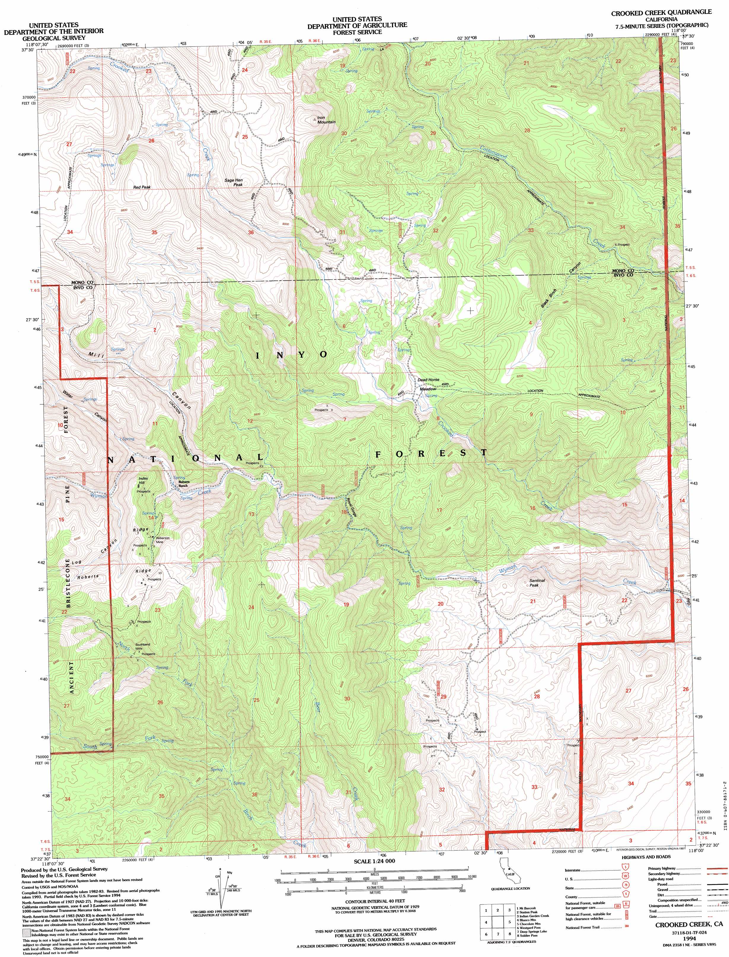
Crooked Creek Topo Map California
To zoom in, hover over the map of Crooked Creek
USGS Topo Quad 37118d1 - 1:24,000 scale
| Topo Map Name: | Crooked Creek |
| USGS Topo Quad ID: | 37118d1 |
| Print Size: | ca. 21 1/4" wide x 27" high |
| Southeast Coordinates: | 37.375° N latitude / 118° W longitude |
| Map Center Coordinates: | 37.4375° N latitude / 118.0625° W longitude |
| U.S. State: | CA |
| Filename: | o37118d1.jpg |
| Download Map JPG Image: | Crooked Creek topo map 1:24,000 scale |
| Map Type: | Topographic |
| Topo Series: | 7.5´ |
| Map Scale: | 1:24,000 |
| Source of Map Images: | United States Geological Survey (USGS) |
| Alternate Map Versions: |
Crooked Creek CA 1987, updated 1987 Download PDF Buy paper map Crooked Creek CA 1987, updated 1994 Download PDF Buy paper map Crooked Creek CA 1994, updated 1997 Download PDF Buy paper map Crooked Creek CA 2012 Download PDF Buy paper map Crooked Creek CA 2015 Download PDF Buy paper map |
| FStopo: | US Forest Service topo Crooked Creek is available: Download FStopo PDF Download FStopo TIF |
1:24,000 Topo Quads surrounding Crooked Creek
White Mountain Peak |
Juniper Mountain |
Dyer |
Piper Peak |
Mohawk Mine |
Chalfant Valley |
Mount Barcroft |
Station Peak |
Indian Garden Creek |
Oasis Divide |
Laws |
Blanco Mountain |
Crooked Creek |
Chocolate Mountain |
Sylvania Canyon |
Poleta Canyon |
Westgard Pass |
Deep Springs Lake |
Soldier Pass |
Horse Thief Canyon |
Big Pine |
Uhlmeyer Spring |
Cowhorn Valley |
Joshua Flats |
East Of Joshua Flats |
> Back to 37118a1 at 1:100,000 scale
> Back to 37118a1 at 1:250,000 scale
> Back to U.S. Topo Maps home
Crooked Creek topo map: Gazetteer
Crooked Creek: Flats
Arrastre Meadow elevation 2213m 7260′Dead Horse Meadow elevation 2385m 7824′
Crooked Creek: Gaps
Royal Gorge elevation 2285m 7496′Crooked Creek: Mines
Southbend Mine elevation 2500m 8202′Wilkerson Mine elevation 2663m 8736′
Crooked Creek: Ridges
Roberts Ridge elevation 2805m 9202′Crooked Creek: Streams
Crooked Creek elevation 1790m 5872′North Fork Birch Creek elevation 2161m 7089′
South Fork Birch Creek elevation 2160m 7086′
Crooked Creek: Summits
Index Hill elevation 2735m 8973′Iron Mountain elevation 2895m 9498′
Red Peak elevation 3082m 10111′
Sage Hen Peak elevation 2871m 9419′
Sentinal Peak elevation 2134m 7001′
Crooked Creek: Valleys
Black Birch Canyon elevation 2070m 6791′Log Canyon elevation 2561m 8402′
Mill Canyon elevation 2443m 8015′
Water Canyon elevation 2525m 8284′
Crooked Creek digital topo map on disk
Buy this Crooked Creek topo map showing relief, roads, GPS coordinates and other geographical features, as a high-resolution digital map file on DVD: