Rovana Topo Map California
To zoom in, hover over the map of Rovana
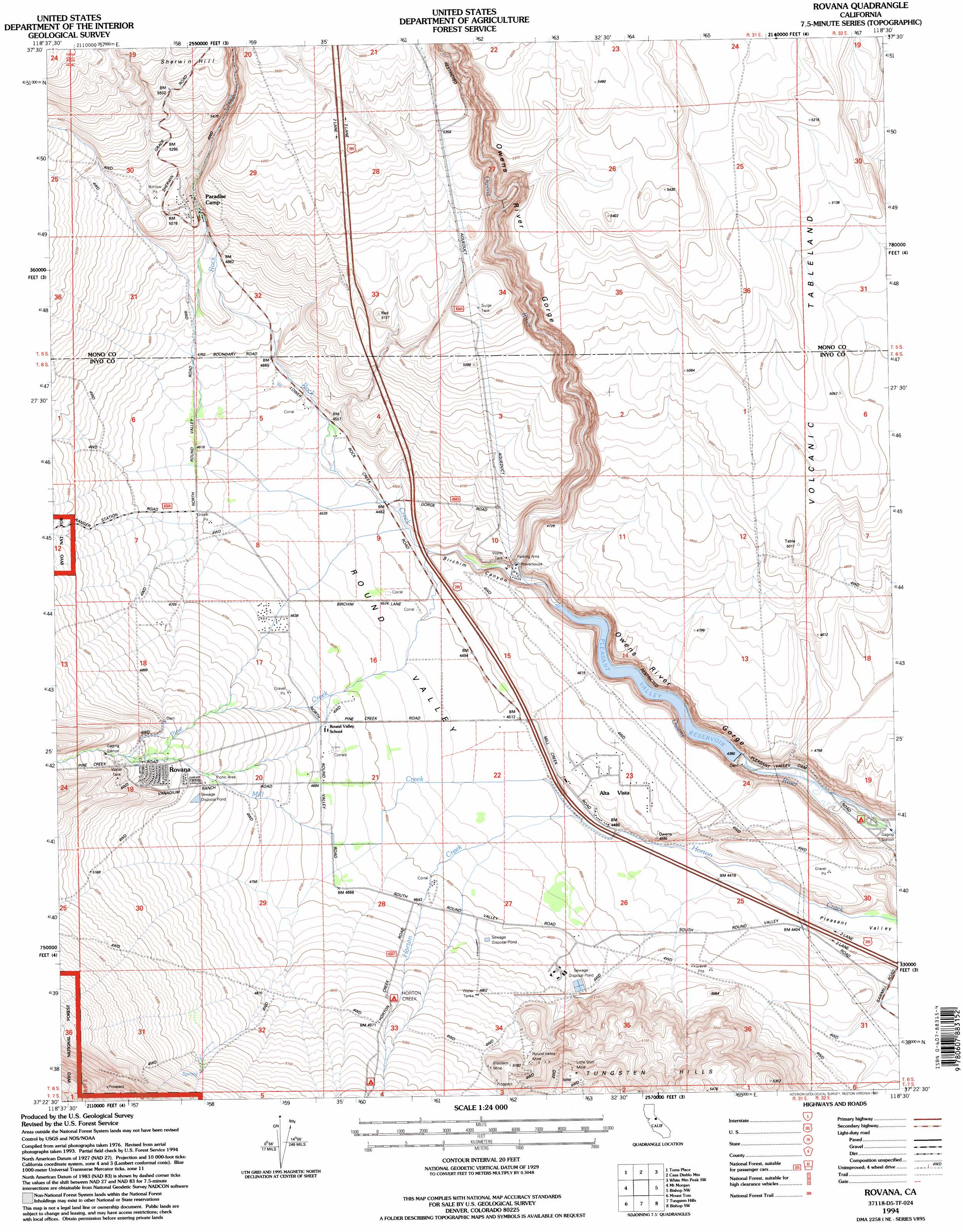
USGS Topo Quad 37118d5 - 1:24,000 scale
| Topo Map Name: | Rovana |
| USGS Topo Quad ID: | 37118d5 |
| Print Size: | ca. 21 1/4" wide x 27" high |
| Southeast Coordinates: | 37.375° N latitude / 118.5° W longitude |
| Map Center Coordinates: | 37.4375° N latitude / 118.5625° W longitude |
| U.S. State: | CA |
| Filename: | o37118d5.jpg |
| Download Map JPG Image: | Rovana topo map 1:24,000 scale |
| Map Type: | Topographic |
| Topo Series: | 7.5´ |
| Map Scale: | 1:24,000 |
| Source of Map Images: | United States Geological Survey (USGS) |
| Alternate Map Versions: |
Rovana CA 1983, updated 1983 Download PDF Buy paper map Rovana CA 1983, updated 1994 Download PDF Buy paper map Rovana CA 1994, updated 1997 Download PDF Buy paper map Rovana CA 2012 Download PDF Buy paper map Rovana CA 2015 Download PDF Buy paper map |
| FStopo: | US Forest Service topo Rovana is available: Download FStopo PDF Download FStopo TIF |
1:24,000 Topo Quads surrounding Rovana
Whitmore Hot Springs |
Watterson Canyon |
Banner Ridge |
Hammil Valley |
White Mountain Peak |
Convict Lake |
Toms Place |
Casa Diablo Mountain |
Chidago Canyon |
Chalfant Valley |
Mount Abbot |
Mount Morgan |
Rovana |
Fish Slough |
Laws |
Mount Hilgard |
Mount Tom |
Tungsten Hills |
Bishop |
Poleta Canyon |
Mount Henry |
Mount Darwin |
Mount Thompson |
Coyote Flat |
Big Pine |
> Back to 37118a1 at 1:100,000 scale
> Back to 37118a1 at 1:250,000 scale
> Back to U.S. Topo Maps home
Rovana topo map: Gazetteer
Rovana: Basins
Round Valley elevation 1475m 4839′Rovana: Dams
Pleasant Valley 6-045 Dam elevation 1323m 4340′Rovana: Mines
Little Shot Mine elevation 1720m 5643′Rattlesnake Prospect elevation 1876m 6154′
Round Valley Mine elevation 1527m 5009′
Round Valley Quarry elevation 1366m 4481′
Western Mine elevation 1517m 4977′
Rovana: Populated Places
Alta Vista elevation 1399m 4589′Round Valley elevation 1430m 4691′
Rovana elevation 1567m 5141′
Rovana: Reservoirs
Pleasant Valley Reservoir elevation 1340m 4396′Rovana: Slopes
Sherwin Grade elevation 1616m 5301′Rovana: Streams
Lower Rock Creek elevation 1348m 4422′Pine Creek elevation 1365m 4478′
Rovana: Valleys
Birchim Canyon elevation 1348m 4422′Elderberry Canyon elevation 1448m 4750′
Owens River Gorge elevation 1312m 4304′
Rovana digital topo map on disk
Buy this Rovana topo map showing relief, roads, GPS coordinates and other geographical features, as a high-resolution digital map file on DVD: