Toms Place Topo Map California
To zoom in, hover over the map of Toms Place
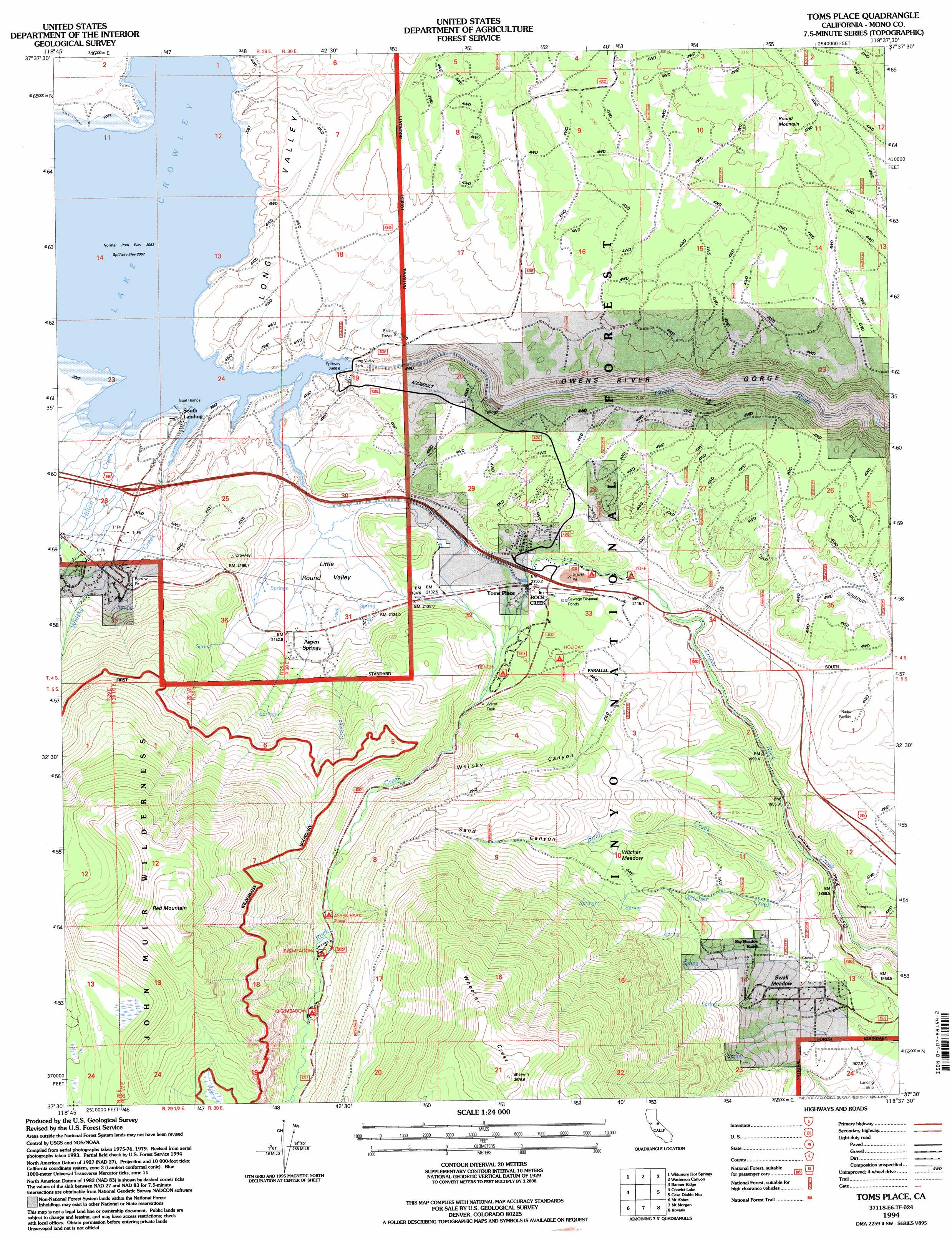
USGS Topo Quad 37118e6 - 1:24,000 scale
| Topo Map Name: | Toms Place |
| USGS Topo Quad ID: | 37118e6 |
| Print Size: | ca. 21 1/4" wide x 27" high |
| Southeast Coordinates: | 37.5° N latitude / 118.625° W longitude |
| Map Center Coordinates: | 37.5625° N latitude / 118.6875° W longitude |
| U.S. State: | CA |
| Filename: | o37118e6.jpg |
| Download Map JPG Image: | Toms Place topo map 1:24,000 scale |
| Map Type: | Topographic |
| Topo Series: | 7.5´ |
| Map Scale: | 1:24,000 |
| Source of Map Images: | United States Geological Survey (USGS) |
| Alternate Map Versions: |
Toms Place CA 1984, updated 1984 Download PDF Buy paper map Toms Place CA 1990, updated 1990 Download PDF Buy paper map Toms Place CA 1994, updated 1997 Download PDF Buy paper map Toms Place CA 2012 Download PDF Buy paper map Toms Place CA 2015 Download PDF Buy paper map |
| FStopo: | US Forest Service topo Toms Place is available: Download FStopo PDF Download FStopo TIF |
1:24,000 Topo Quads surrounding Toms Place
Crestview |
Dexter Canyon |
Glass Mountain |
Benton Hot Spirngs |
Benton |
Old Mammoth |
Whitmore Hot Springs |
Watterson Canyon |
Banner Ridge |
Hammil Valley |
Bloody Mountain |
Convict Lake |
Toms Place |
Casa Diablo Mountain |
Chidago Canyon |
Graveyard Peak |
Mount Abbot |
Mount Morgan |
Rovana |
Fish Slough |
Florence Lake |
Mount Hilgard |
Mount Tom |
Tungsten Hills |
Bishop |
> Back to 37118e1 at 1:100,000 scale
> Back to 37118a1 at 1:250,000 scale
> Back to U.S. Topo Maps home
Toms Place topo map: Gazetteer
Toms Place: Basins
Little Round Valley elevation 2105m 6906′Toms Place: Dams
Long Valley Dam elevation 2076m 6811′Toms Place: Flats
Sherwin Meadow elevation 1998m 6555′Swall Meadow elevation 2000m 6561′
Witcher Meadow elevation 2328m 7637′
Toms Place: Gaps
Sherwin Summit elevation 1959m 6427′Toms Place: Populated Places
Aspen Springs elevation 2167m 7109′South Landing elevation 2074m 6804′
Toms Place elevation 2161m 7089′
Toms Place: Reservoirs
Lake Crowley elevation 2076m 6811′Toms Place: Streams
Birch Creek elevation 1911m 6269′Crooked Creek elevation 2063m 6768′
Hilton Creek elevation 2067m 6781′
Rock Creek elevation 2160m 7086′
Whisky Creek elevation 2074m 6804′
Witcher Creek elevation 1949m 6394′
Toms Place: Summits
Red Mountain elevation 3495m 11466′Round Mountain elevation 2326m 7631′
Toms Place: Tunnels
Tunnel Number One elevation 2222m 7290′Toms Place: Valleys
Sand Canyon elevation 2361m 7746′Whisky Canyon elevation 2099m 6886′
Toms Place digital topo map on disk
Buy this Toms Place topo map showing relief, roads, GPS coordinates and other geographical features, as a high-resolution digital map file on DVD: