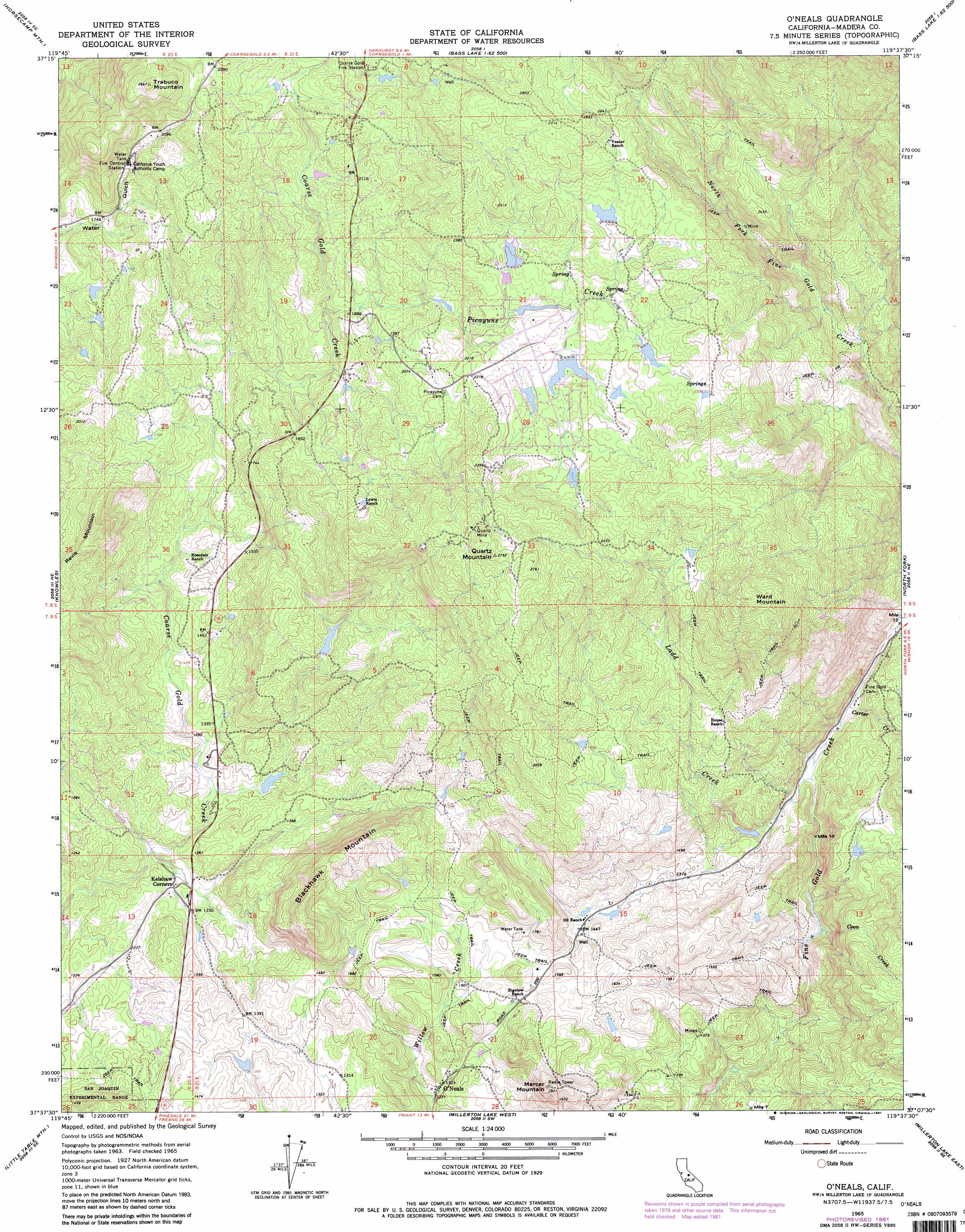
O'Neals Topo Map California
To zoom in, hover over the map of O'Neals
USGS Topo Quad 37119b6 - 1:24,000 scale
| Topo Map Name: | O'Neals |
| USGS Topo Quad ID: | 37119b6 |
| Print Size: | ca. 21 1/4" wide x 27" high |
| Southeast Coordinates: | 37.125° N latitude / 119.625° W longitude |
| Map Center Coordinates: | 37.1875° N latitude / 119.6875° W longitude |
| U.S. State: | CA |
| Filename: | o37119b6.jpg |
| Download Map JPG Image: | O'Neals topo map 1:24,000 scale |
| Map Type: | Topographic |
| Topo Series: | 7.5´ |
| Map Scale: | 1:24,000 |
| Source of Map Images: | United States Geological Survey (USGS) |
| Alternate Map Versions: |
O'Neals CA 1965, updated 1966 Download PDF Buy paper map O'Neals CA 1965, updated 1981 Download PDF Buy paper map O'Neals CA 2012 Download PDF Buy paper map O'Neals CA 2015 Download PDF Buy paper map |
| FStopo: | US Forest Service topo O'Neals is available: Download FStopo PDF Download FStopo TIF |
1:24,000 Topo Quads surrounding O'Neals
Mariposa |
Stumpfield Mountain |
Fish Camp |
White Chief Mountain |
Little Shuteye Peak |
Ben Hur |
Horsecamp Mountain |
Ahwahnee |
Bass Lake |
Shuteye Peak |
Raymond |
Knowles |
O'Neals |
North Fork |
Cascadel Point |
Daulton |
Little Table Mountain |
Millerton Lake West |
Millerton Lake East |
Auberry |
Gregg |
Lanes Bridge |
Friant |
Academy |
Humphreys Station |
> Back to 37119a1 at 1:100,000 scale
> Back to 37118a1 at 1:250,000 scale
> Back to U.S. Topo Maps home
O'Neals topo map: Gazetteer
O'Neals: Mines
Carnation Mine elevation 754m 2473′Quartz Mine elevation 793m 2601′
O'Neals: Parks
Indian Lakes Park elevation 682m 2237′O'Neals: Populated Places
Indian Lakes Estates elevation 685m 2247′Magnet (historical) elevation 428m 1404′
Narbo (historical) elevation 608m 1994′
O'Neals elevation 399m 1309′
Willow Glen (historical) elevation 558m 1830′
O'Neals: Streams
Carter Creek elevation 379m 1243′Coon Creek elevation 341m 1118′
Ladd Creek elevation 377m 1236′
Picayune Creek elevation 545m 1788′
O'Neals: Summits
Blackhawk Mountain elevation 624m 2047′Mercer Mountain elevation 589m 1932′
Quartz Mountain elevation 838m 2749′
Revis Mountain elevation 659m 2162′
Trabuco Mountain elevation 806m 2644′
Ward Mountain elevation 847m 2778′
O'Neals digital topo map on disk
Buy this O'Neals topo map showing relief, roads, GPS coordinates and other geographical features, as a high-resolution digital map file on DVD: