Ben Hur Topo Map California
To zoom in, hover over the map of Ben Hur
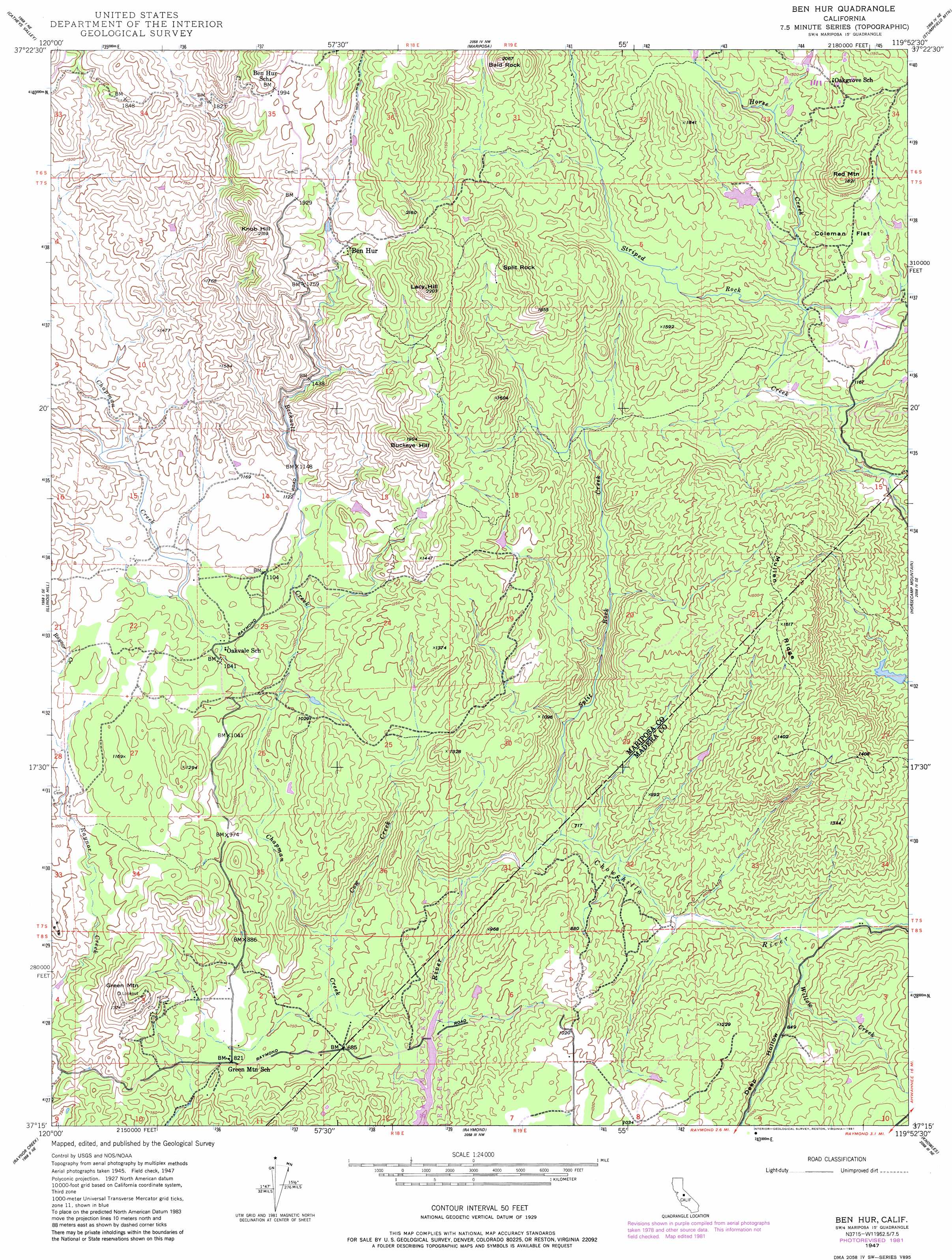
USGS Topo Quad 37119c8 - 1:24,000 scale
| Topo Map Name: | Ben Hur |
| USGS Topo Quad ID: | 37119c8 |
| Print Size: | ca. 21 1/4" wide x 27" high |
| Southeast Coordinates: | 37.25° N latitude / 119.875° W longitude |
| Map Center Coordinates: | 37.3125° N latitude / 119.9375° W longitude |
| U.S. State: | CA |
| Filename: | o37119c8.jpg |
| Download Map JPG Image: | Ben Hur topo map 1:24,000 scale |
| Map Type: | Topographic |
| Topo Series: | 7.5´ |
| Map Scale: | 1:24,000 |
| Source of Map Images: | United States Geological Survey (USGS) |
| Alternate Map Versions: |
Ben Hur CA 1947, updated 1970 Download PDF Buy paper map Ben Hur CA 1947, updated 1970 Download PDF Buy paper map Ben Hur CA 1947, updated 1975 Download PDF Buy paper map Ben Hur CA 1947, updated 1981 Download PDF Buy paper map Ben Hur CA 1947, updated 1981 Download PDF Buy paper map Ben Hur CA 1947, updated 1988 Download PDF Buy paper map Ben Hur CA 1948, updated 1948 Download PDF Buy paper map Ben Hur CA 1948, updated 1948 Download PDF Buy paper map Ben Hur CA 2012 Download PDF Buy paper map Ben Hur CA 2015 Download PDF Buy paper map |
1:24,000 Topo Quads surrounding Ben Hur
Hornitos |
Bear Valley |
Feliciana Mountain |
Buckingham Mountain |
Wawona |
Indian Gulch |
Catheys Valley |
Mariposa |
Stumpfield Mountain |
Fish Camp |
Owens Reservoir |
Illinois Hill |
Ben Hur |
Horsecamp Mountain |
Ahwahnee |
Le Grand |
Raynor Creek |
Raymond |
Knowles |
O'Neals |
Berenda |
Kismet |
Daulton |
Little Table Mountain |
Millerton Lake West |
> Back to 37119a1 at 1:100,000 scale
> Back to 37118a1 at 1:250,000 scale
> Back to U.S. Topo Maps home
Ben Hur topo map: Gazetteer
Ben Hur: Dams
Hendricks 675 Dam elevation 381m 1250′Ben Hur: Flats
Coleman Flat elevation 408m 1338′Ben Hur: Populated Places
Ben Hur elevation 534m 1751′Ben Hur: Ridges
Mullen Ridge elevation 488m 1601′Ben Hur: Streams
Becknell Creek elevation 288m 944′Chapman Creek elevation 180m 590′
Cow Creek elevation 211m 692′
Horse Creek elevation 350m 1148′
Split Rock Creek elevation 187m 613′
Willow Creek elevation 199m 652′
Ben Hur: Summits
Bald Rock elevation 621m 2037′Buckeye Hill elevation 578m 1896′
Green Mountain elevation 415m 1361′
Knob Hill elevation 646m 2119′
Lacy Hill elevation 665m 2181′
Red Mountain elevation 553m 1814′
Split Rock elevation 594m 1948′
Ben Hur: Valleys
Deep Hollow elevation 212m 695′Ben Hur digital topo map on disk
Buy this Ben Hur topo map showing relief, roads, GPS coordinates and other geographical features, as a high-resolution digital map file on DVD: