Little Shuteye Peak Topo Map California
To zoom in, hover over the map of Little Shuteye Peak
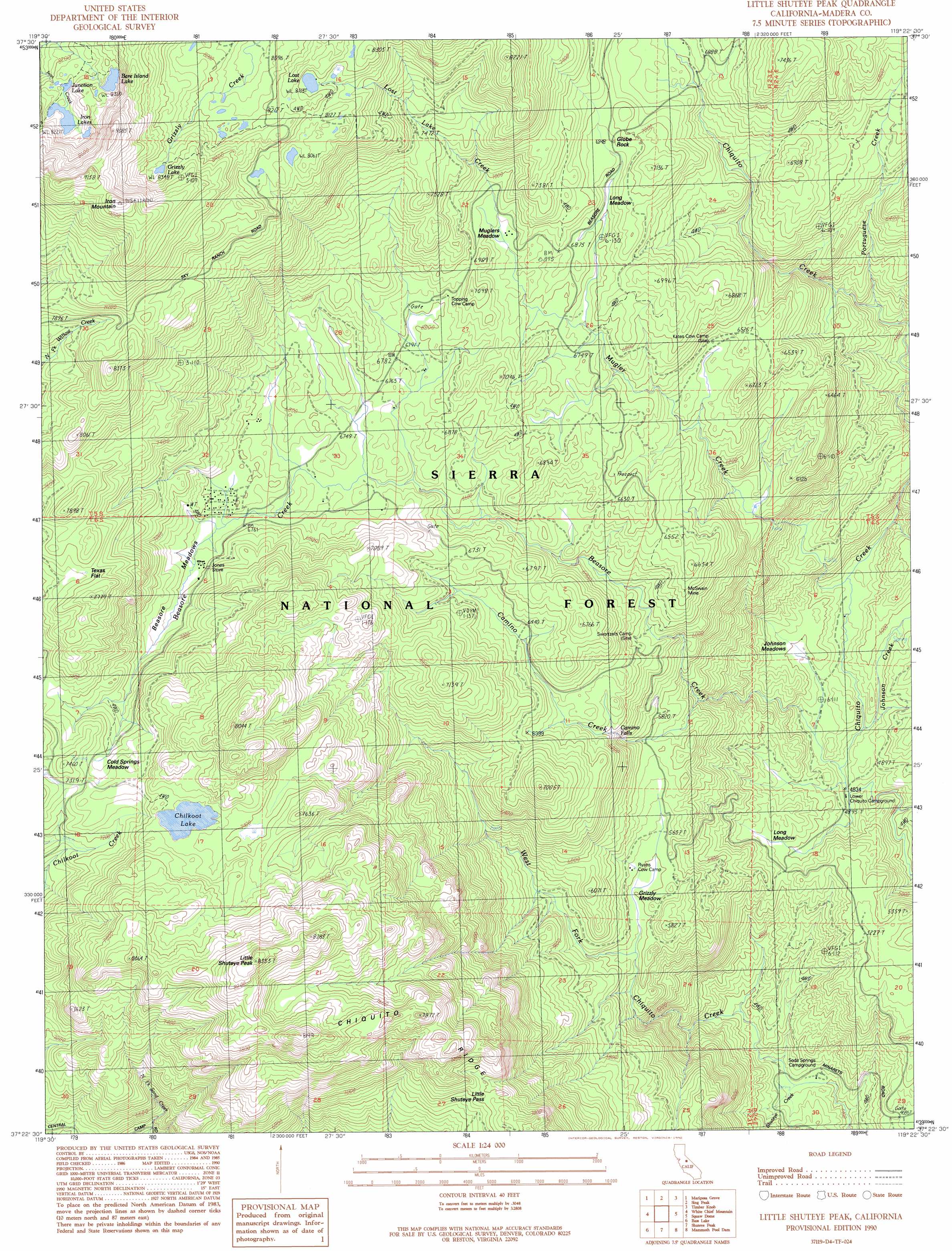
USGS Topo Quad 37119d4 - 1:24,000 scale
| Topo Map Name: | Little Shuteye Peak |
| USGS Topo Quad ID: | 37119d4 |
| Print Size: | ca. 21 1/4" wide x 27" high |
| Southeast Coordinates: | 37.375° N latitude / 119.375° W longitude |
| Map Center Coordinates: | 37.4375° N latitude / 119.4375° W longitude |
| U.S. State: | CA |
| Filename: | o37119d4.jpg |
| Download Map JPG Image: | Little Shuteye Peak topo map 1:24,000 scale |
| Map Type: | Topographic |
| Topo Series: | 7.5´ |
| Map Scale: | 1:24,000 |
| Source of Map Images: | United States Geological Survey (USGS) |
| Alternate Map Versions: |
Little Shuteye Peak CA 1990, updated 1990 Download PDF Buy paper map Little Shuteye Peak CA 1990, updated 1990 Download PDF Buy paper map Little Shuteye Peak CA 2004, updated 2007 Download PDF Buy paper map Little Shuteye Peak CA 2012 Download PDF Buy paper map Little Shuteye Peak CA 2015 Download PDF Buy paper map |
| FStopo: | US Forest Service topo Little Shuteye Peak is available: Download FStopo PDF Download FStopo TIF |
1:24,000 Topo Quads surrounding Little Shuteye Peak
El Capitan |
Half Dome |
Merced Peak |
Mount Lyell |
Mount Ritter |
Wawona |
Mariposa Grove |
Sing Peak |
Timber Knob |
Cattle Mountain |
Fish Camp |
White Chief Mountain |
Little Shuteye Peak |
Squaw Dome |
Balloon Dome |
Ahwahnee |
Bass Lake |
Shuteye Peak |
Mammoth Pool Dam |
Kaiser Peak |
O'Neals |
North Fork |
Cascadel Point |
Musick Mountain |
Huntington Lake |
> Back to 37119a1 at 1:100,000 scale
> Back to 37118a1 at 1:250,000 scale
> Back to U.S. Topo Maps home
Little Shuteye Peak topo map: Gazetteer
Little Shuteye Peak: Bars
Blackmans Bar (historical) elevation 1358m 4455′Little Shuteye Peak: Falls
Camino Falls elevation 1867m 6125′Little Shuteye Peak: Flats
Beasore Meadows elevation 2074m 6804′Cold Springs Meadow elevation 2208m 7244′
Grizzly Meadow elevation 1707m 5600′
Johnson Meadows elevation 1524m 5000′
Long Meadow elevation 2083m 6833′
Long Meadow elevation 1542m 5059′
Muglers Meadow elevation 2105m 6906′
Tex Flat (historical) elevation 1514m 4967′
Texas Flat elevation 2293m 7522′
Little Shuteye Peak: Gaps
Little Shuteye Pass elevation 2147m 7043′Little Shuteye Peak: Lakes
Bare Island Lake elevation 2545m 8349′Chilkoot Lake elevation 2284m 7493′
Grizzly Lake elevation 2542m 8339′
Iron Lakes elevation 2506m 8221′
Junction Lake elevation 2510m 8234′
Lost Lake elevation 2493m 8179′
Little Shuteye Peak: Mines
McSwain Mine elevation 1831m 6007′North McSwain Mine (historical) elevation 2010m 6594′
Strasbaugh Mine (historical) elevation 1999m 6558′
Little Shuteye Peak: Pillars
Globe Rock elevation 2126m 6975′Little Shuteye Peak: Streams
Beasore Creek elevation 1686m 5531′Camino Creek elevation 1686m 5531′
Johnson Creek elevation 1476m 4842′
Lost Lake Creek elevation 2094m 6870′
Mugler Creek elevation 1498m 4914′
Portuguese Creek elevation 1732m 5682′
Shuteye Creek elevation 1346m 4416′
Little Shuteye Peak: Summits
Iron Mountain elevation 2794m 9166′Little Shuteye Peak elevation 2531m 8303′
Little Shuteye Peak digital topo map on disk
Buy this Little Shuteye Peak topo map showing relief, roads, GPS coordinates and other geographical features, as a high-resolution digital map file on DVD: