Mariposa Grove Topo Map California
To zoom in, hover over the map of Mariposa Grove
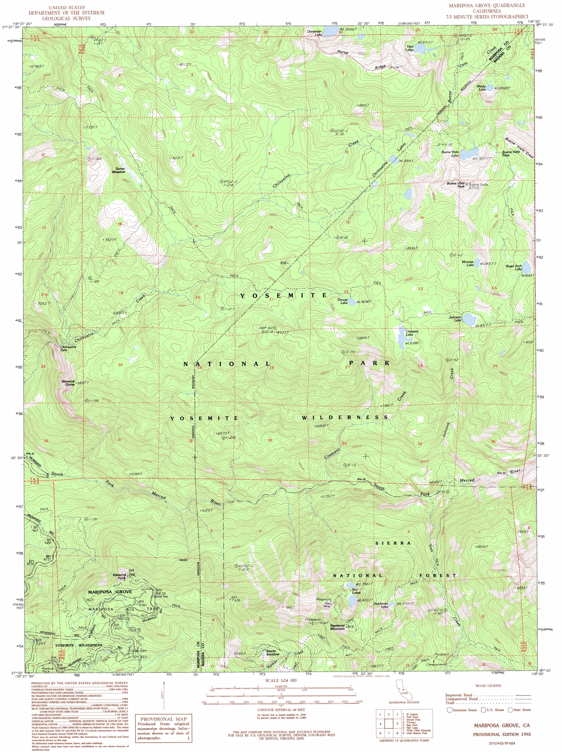
USGS Topo Quad 37119e5 - 1:24,000 scale
| Topo Map Name: | Mariposa Grove |
| USGS Topo Quad ID: | 37119e5 |
| Print Size: | ca. 21 1/4" wide x 27" high |
| Southeast Coordinates: | 37.5° N latitude / 119.5° W longitude |
| Map Center Coordinates: | 37.5625° N latitude / 119.5625° W longitude |
| U.S. State: | CA |
| Filename: | o37119e5.jpg |
| Download Map JPG Image: | Mariposa Grove topo map 1:24,000 scale |
| Map Type: | Topographic |
| Topo Series: | 7.5´ |
| Map Scale: | 1:24,000 |
| Source of Map Images: | United States Geological Survey (USGS) |
| Alternate Map Versions: |
Mariposa Grove CA 1992, updated 1995 Download PDF Buy paper map Mariposa Grove CA 2004, updated 2007 Download PDF Buy paper map Mariposa Grove CA 2012 Download PDF Buy paper map Mariposa Grove CA 2015 Download PDF Buy paper map |
| FStopo: | US Forest Service topo Mariposa Grove is available: Download FStopo PDF Download FStopo TIF |
1:24,000 Topo Quads surrounding Mariposa Grove
Ackerson Mountain |
Tamarack Flat |
Yosemite Falls |
Tenaya Lake |
Vogelsang Peak |
El Portal |
El Capitan |
Half Dome |
Merced Peak |
Mount Lyell |
Buckingham Mountain |
Wawona |
Mariposa Grove |
Sing Peak |
Timber Knob |
Stumpfield Mountain |
Fish Camp |
White Chief Mountain |
Little Shuteye Peak |
Squaw Dome |
Horsecamp Mountain |
Ahwahnee |
Bass Lake |
Shuteye Peak |
Mammoth Pool Dam |
> Back to 37119e1 at 1:100,000 scale
> Back to 37118a1 at 1:250,000 scale
> Back to U.S. Topo Maps home
Mariposa Grove topo map: Gazetteer
Mariposa Grove: Falls
Chilnualna Fall elevation 1946m 6384′Mariposa Grove: Flats
Biledo Meadow elevation 2149m 7050′Last Chance Meadow elevation 2369m 7772′
Turner Meadow elevation 2440m 8005′
Mariposa Grove: Gaps
Buena Vista Pass elevation 2848m 9343′Mariposa Grove: Lakes
Buena Vista Lake elevation 2768m 9081′Chilnualna Lakes elevation 2594m 8510′
Crescent Lake elevation 2558m 8392′
Dutchman Lake elevation 2362m 7749′
Grouse Lake elevation 2520m 8267′
Hart Lakes elevation 2658m 8720′
Johnson Lake elevation 2518m 8261′
Minnow Lake elevation 2640m 8661′
Ostrander Lake elevation 2593m 8507′
Royal Arch Lake elevation 2655m 8710′
Star Lakes elevation 2451m 8041′
Windy Lake elevation 2593m 8507′
Mariposa Grove: Mines
Star Mine elevation 2571m 8435′Mariposa Grove: Ridges
Horse Ridge elevation 2823m 9261′Mariposa Grove: Streams
Crescent Creek elevation 1652m 5419′Iron Creek elevation 1809m 5935′
Johnson Creek elevation 1826m 5990′
Mariposa Grove: Summits
Buena Vista Peak elevation 2956m 9698′Mount Raymond elevation 2650m 8694′
Wawona Dome elevation 2105m 6906′
Wawona Point elevation 1992m 6535′
Mariposa Grove: Woods
Mariposa Grove elevation 1950m 6397′Mariposa Grove digital topo map on disk
Buy this Mariposa Grove topo map showing relief, roads, GPS coordinates and other geographical features, as a high-resolution digital map file on DVD: