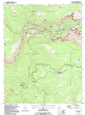
El Capitan Topo Map California
To zoom in, hover over the map of El Capitan
USGS Topo Quad 37119f6 - 1:24,000 scale
| Topo Map Name: | El Capitan |
| USGS Topo Quad ID: | 37119f6 |
| Print Size: | ca. 21 1/4" wide x 27" high |
| Southeast Coordinates: | 37.625° N latitude / 119.625° W longitude |
| Map Center Coordinates: | 37.6875° N latitude / 119.6875° W longitude |
| U.S. State: | CA |
| Filename: | o37119f6.jpg |
| Download Map JPG Image: | El Capitan topo map 1:24,000 scale |
| Map Type: | Topographic |
| Topo Series: | 7.5´ |
| Map Scale: | 1:24,000 |
| Source of Map Images: | United States Geological Survey (USGS) |
| Alternate Map Versions: |
El Capitan CA 1990, updated 1990 Download PDF Buy paper map El Capitan CA 1992, updated 1995 Download PDF Buy paper map El Capitan CA 1997, updated 2002 Download PDF Buy paper map El Capitan CA 2004, updated 2007 Download PDF Buy paper map El Capitan CA 2012 Download PDF Buy paper map El Capitan CA 2015 Download PDF Buy paper map |
| FStopo: | US Forest Service topo El Capitan is available: Download FStopo PDF Download FStopo TIF |
1:24,000 Topo Quads surrounding El Capitan
> Back to 37119e1 at 1:100,000 scale
> Back to 37118a1 at 1:250,000 scale
> Back to U.S. Topo Maps home
El Capitan topo map: Gazetteer
El Capitan: Benches
The Rostrum elevation 1416m 4645′El Capitan: Bridges
El Capitan Bridge elevation 1205m 3953′Pohono Bridge elevation 1179m 3868′
El Capitan: Cliffs
Cathedral Rocks elevation 1833m 6013′Crocker Point elevation 2165m 7103′
Dewey Point elevation 2236m 7335′
Fireplace Bluffs elevation 1928m 6325′
Leaning Tower elevation 1810m 5938′
Rockslides elevation 1577m 5173′
Stanford Point elevation 1599m 5246′
El Capitan: Dams
Cascade Dam elevation 1180m 3871′El Capitan: Falls
Bridalveil Fall elevation 1352m 4435′Ribbon Fall elevation 1918m 6292′
Silver Strand Falls elevation 1962m 6437′
The Cascades elevation 1263m 4143′
Wildcat Falls elevation 1296m 4251′
El Capitan: Flats
Bridalveil Meadow elevation 1187m 3894′Elevenmile Meadow elevation 1627m 5337′
McGurk Meadow elevation 2096m 6876′
Monroe Meadows elevation 2206m 7237′
Ribbon Meadow elevation 2308m 7572′
Summit Meadow elevation 2229m 7312′
Westfall Meadows elevation 2156m 7073′
El Capitan: Gaps
Badger Pass elevation 2279m 7477′The Gateway elevation 1021m 3349′
El Capitan: Lakes
El Capitan Meadow elevation 1205m 3953′El Capitan: Pillars
Cathedral Spires elevation 1824m 5984′Church Tower elevation 1612m 5288′
Elephant Rock elevation 1435m 4708′
Gunsight elevation 1483m 4865′
K P Pinnacle elevation 1885m 6184′
Pulpit Rock elevation 1260m 4133′
El Capitan: Populated Places
Yosemite West elevation 1788m 5866′El Capitan: Ridges
Bridalveil Moraine elevation 1198m 3930′El Capitan Moraine elevation 1367m 4484′
Henness Ridge elevation 1875m 6151′
El Capitan: Slopes
Washburn Slide elevation 1443m 4734′El Capitan: Springs
Black Spring elevation 1192m 3910′Fern Spring elevation 1193m 3914′
Moss Spring elevation 1204m 3950′
El Capitan: Streams
Artist Creek elevation 1175m 3854′Avalanche Creek elevation 834m 2736′
Bridalveil Creek elevation 1190m 3904′
Cascade Creek elevation 1042m 3418′
Coyote Creek elevation 1801m 5908′
Fireplace Creek elevation 1160m 3805′
Grouse Creek elevation 887m 2910′
Meadow Brook elevation 1193m 3914′
Rail Creek elevation 1595m 5232′
Ribbon Creek elevation 1205m 3953′
Strawberry Creek elevation 1674m 5492′
Tamarack Creek elevation 1283m 4209′
Wildcat Creek elevation 1040m 3412′
El Capitan: Summits
Devils Dance Floor elevation 2078m 6817′El Capitan elevation 2307m 7568′
Old Inspiration Point elevation 1991m 6532′
Turtleback Dome elevation 1605m 5265′
El Capitan: Trails
El Capitan Trail (historical) elevation 2351m 7713′Pohono Trail elevation 2090m 6856′
El Capitan: Tunnels
Wawona Tunnel elevation 1507m 4944′El Capitan: Valleys
El Capitan Gully elevation 1425m 4675′Merced Gorge elevation 719m 2358′
Yosemite Valley elevation 1179m 3868′
El Capitan digital topo map on disk
Buy this El Capitan topo map showing relief, roads, GPS coordinates and other geographical features, as a high-resolution digital map file on DVD:


