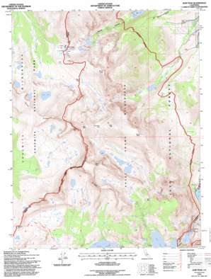
Koip Peak Topo Map California
To zoom in, hover over the map of Koip Peak
USGS Topo Quad 37119g2 - 1:24,000 scale
| Topo Map Name: | Koip Peak |
| USGS Topo Quad ID: | 37119g2 |
| Print Size: | ca. 21 1/4" wide x 27" high |
| Southeast Coordinates: | 37.75° N latitude / 119.125° W longitude |
| Map Center Coordinates: | 37.8125° N latitude / 119.1875° W longitude |
| U.S. State: | CA |
| Filename: | o37119g2.jpg |
| Download Map JPG Image: | Koip Peak topo map 1:24,000 scale |
| Map Type: | Topographic |
| Topo Series: | 7.5´ |
| Map Scale: | 1:24,000 |
| Source of Map Images: | United States Geological Survey (USGS) |
| Alternate Map Versions: |
Koip Peak CA 1988, updated 1989 Download PDF Buy paper map Koip Peak CA 1992, updated 1995 Download PDF Buy paper map Koip Peak CA 1994, updated 1997 Download PDF Buy paper map Koip Peak CA 2012 Download PDF Buy paper map Koip Peak CA 2015 Download PDF Buy paper map |
| FStopo: | US Forest Service topo Koip Peak is available: Download FStopo PDF Download FStopo TIF |
1:24,000 Topo Quads surrounding Koip Peak
> Back to 37119e1 at 1:100,000 scale
> Back to 37118a1 at 1:250,000 scale
> Back to U.S. Topo Maps home
Koip Peak topo map: Gazetteer
Koip Peak: Dams
Agnew Lake 104-038 Dam elevation 2606m 8549′Gem Lake 104-037 Dam elevation 2763m 9064′
Rush Creek Meadow 104-034 Dam elevation 2873m 9425′
Sardine Lake 6-036 Dam elevation 3030m 9940′
Koip Peak: Gaps
Donohue Pass elevation 3373m 11066′Gem Pass elevation 3203m 10508′
Koip Peak Pass elevation 3433m 11263′
Mono Pass elevation 3238m 10623′
Parker Pass elevation 3384m 11102′
Koip Peak: Lakes
Agnew Lake elevation 2591m 8500′Alger Lakes elevation 3242m 10636′
Billy Lake elevation 2801m 9189′
Bingaman Lake elevation 3396m 11141′
Gem Lake elevation 2763m 9064′
Helen Lake elevation 3336m 10944′
Lost Lakes elevation 3327m 10915′
Parker Lake elevation 2534m 8313′
Parker Pass Lake elevation 3337m 10948′
Sardine Lakes elevation 3128m 10262′
Spillway Lake elevation 3193m 10475′
Summit Lake elevation 3239m 10626′
Upper Sardine Lake elevation 3179m 10429′
Walker Lake elevation 2419m 7936′
Koip Peak: Reservoirs
Lower Sardine Lake elevation 3030m 9940′Waugh Lake elevation 2873m 9425′
Koip Peak: Ridges
Koip Crest elevation 3736m 12257′Kuna Crest elevation 3958m 12985′
Koip Peak: Streams
Alger Creek elevation 2204m 7230′Crest Creek elevation 2784m 9133′
Koip Peak: Summits
Blacktop Peak elevation 3881m 12732′Donohue Peak elevation 3651m 11978′
Koip Peak elevation 3954m 12972′
Kuna Peak elevation 3958m 12985′
Mount Lewis elevation 3765m 12352′
Mount Wood elevation 3855m 12647′
Parker Peak elevation 3919m 12857′
Koip Peak digital topo map on disk
Buy this Koip Peak topo map showing relief, roads, GPS coordinates and other geographical features, as a high-resolution digital map file on DVD:


