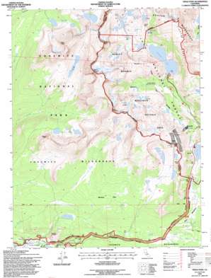
Tioga Pass Topo Map California
To zoom in, hover over the map of Tioga Pass
USGS Topo Quad 37119h3 - 1:24,000 scale
| Topo Map Name: | Tioga Pass |
| USGS Topo Quad ID: | 37119h3 |
| Print Size: | ca. 21 1/4" wide x 27" high |
| Southeast Coordinates: | 37.875° N latitude / 119.25° W longitude |
| Map Center Coordinates: | 37.9375° N latitude / 119.3125° W longitude |
| U.S. State: | CA |
| Filename: | o37119h3.jpg |
| Download Map JPG Image: | Tioga Pass topo map 1:24,000 scale |
| Map Type: | Topographic |
| Topo Series: | 7.5´ |
| Map Scale: | 1:24,000 |
| Source of Map Images: | United States Geological Survey (USGS) |
| Alternate Map Versions: |
Tioga Pass CA 1990, updated 1990 Download PDF Buy paper map Tioga Pass CA 1992, updated 1995 Download PDF Buy paper map Tioga Pass CA 1994, updated 1997 Download PDF Buy paper map Tioga Pass CA 1994, updated 1997 Download PDF Buy paper map Tioga Pass CA 2012 Download PDF Buy paper map Tioga Pass CA 2015 Download PDF Buy paper map |
| FStopo: | US Forest Service topo Tioga Pass is available: Download FStopo PDF Download FStopo TIF |
1:24,000 Topo Quads surrounding Tioga Pass
> Back to 37119e1 at 1:100,000 scale
> Back to 37118a1 at 1:250,000 scale
> Back to U.S. Topo Maps home
Tioga Pass topo map: Gazetteer
Tioga Pass: Areas
Harvey Monroe Hall Research Natural Area elevation 3159m 10364′Tioga Pass: Cliffs
Dore Cliff elevation 3470m 11384′Tioga Pass: Dams
Saddlebag 104-039 Dam elevation 3076m 10091′Tioga Lake 104-040 Dam elevation 2940m 9645′
Tioga Pass: Flats
Dana Meadows elevation 2965m 9727′Moraine Flat elevation 2960m 9711′
Tioga Pass: Gaps
Dore Pass elevation 3443m 11295′Lundy Pass elevation 3162m 10374′
Tioga Pass elevation 3031m 9944′
Tioga Pass: Glaciers
Conness Glacier elevation 3520m 11548′Tioga Pass: Lakes
Alpine Lake elevation 3362m 11030′Big Horn Lake elevation 3314m 10872′
Cascade Lake elevation 3146m 10321′
Conness Lakes elevation 3236m 10616′
Dog Lake elevation 2798m 9179′
Fantail Lake elevation 3019m 9904′
Finger Lake elevation 3241m 10633′
Gardisky Lake elevation 3201m 10501′
Gaylor Lakes elevation 3150m 10334′
Granite Lakes elevation 3174m 10413′
Green Treble Lake elevation 3118m 10229′
Greenstone Lake elevation 3092m 10144′
Hummingbird Lake elevation 3120m 10236′
Maul Lake elevation 3117m 10226′
McCabe Lakes elevation 3116m 10223′
Odell Lake elevation 3128m 10262′
Oneida Lake elevation 2947m 9668′
Roosevelt Lake elevation 3106m 10190′
Shamrock Lake elevation 3129m 10265′
Shell Lake elevation 3007m 9865′
Skelton Lakes elevation 3218m 10557′
Spuller Lake elevation 3132m 10275′
Steelhead Lake elevation 3133m 10278′
Twin Lakes elevation 3178m 10426′
Upper Gaylor Lake elevation 3204m 10511′
Upper McCabe Lake elevation 3189m 10462′
Wasco Lake elevation 3143m 10311′
Young Lakes elevation 3046m 9993′
Z Lake elevation 3182m 10439′
Tioga Pass: Mines
Great Sierra Mine elevation 3280m 10761′Hess Mine elevation 3134m 10282′
May Lundy Mine elevation 2951m 9681′
Tioga Pass: Reservoirs
Saddlebag Lake elevation 3076m 10091′Tioga Lake elevation 2940m 9645′
Tioga Pass: Ridges
Tioga Crest elevation 3445m 11302′Tioga Pass: Springs
Soda Springs elevation 2623m 8605′Tioga Pass: Streams
Dana Fork elevation 2618m 8589′Lyell Fork elevation 2618m 8589′
Parker Pass Creek elevation 2889m 9478′
Tioga Pass: Summits
Gaylor Peak elevation 3351m 10994′Lembert Dome elevation 2871m 9419′
Mount Conness elevation 3825m 12549′
North Peak elevation 3728m 12230′
Puppy Dome elevation 2671m 8763′
Ragged Peak elevation 3312m 10866′
Sheep Peak elevation 3601m 11814′
White Mountain elevation 3674m 12053′
Tioga Pass: Trails
Gaylor Lakes Trail elevation 3156m 10354′Tioga Pass: Valleys
Glacier Canyon elevation 2939m 9642′Tioga Pass digital topo map on disk
Buy this Tioga Pass topo map showing relief, roads, GPS coordinates and other geographical features, as a high-resolution digital map file on DVD:


