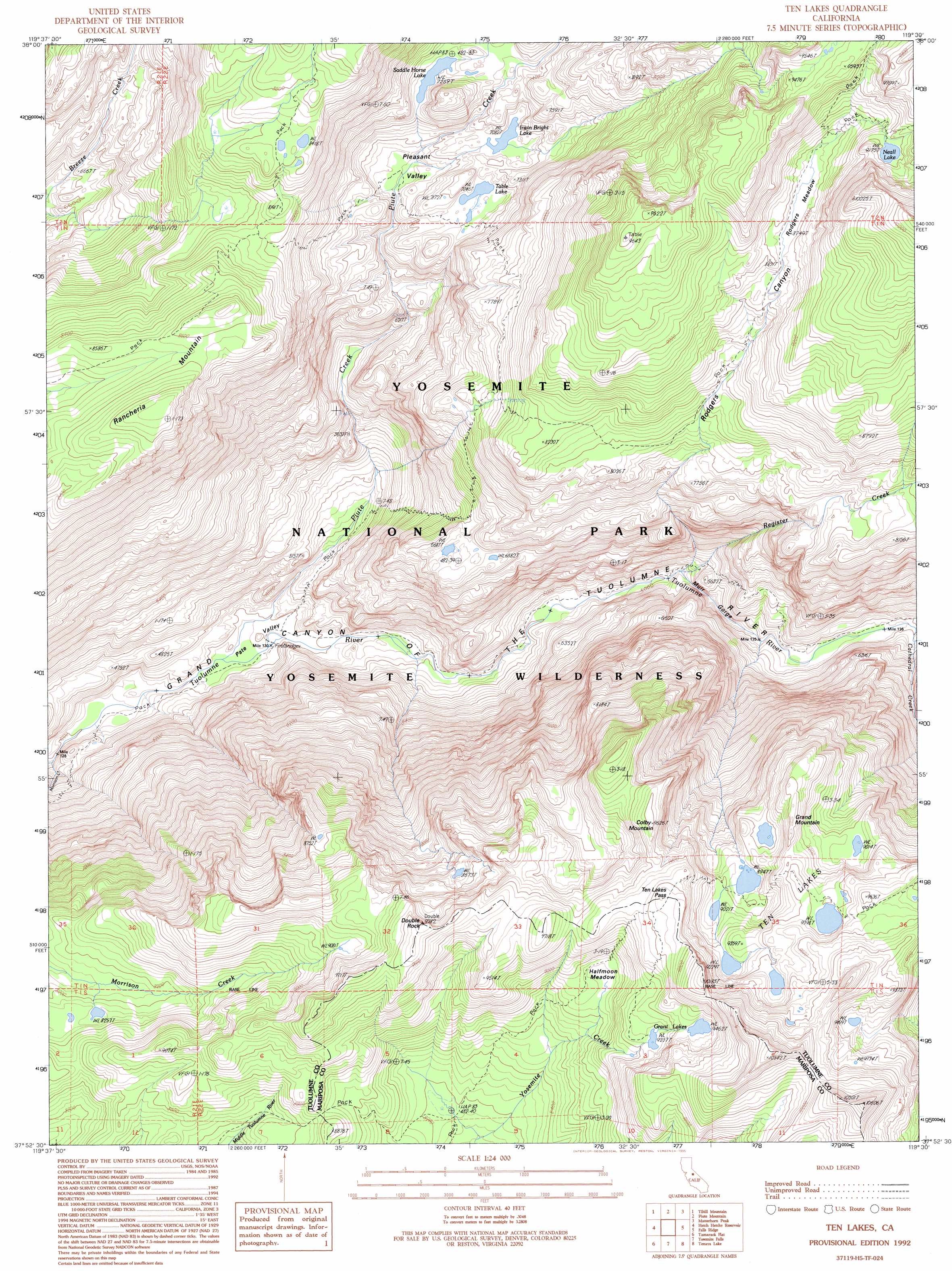
Ten Lakes Topo Map California
To zoom in, hover over the map of Ten Lakes
USGS Topo Quad 37119h5 - 1:24,000 scale
| Topo Map Name: | Ten Lakes |
| USGS Topo Quad ID: | 37119h5 |
| Print Size: | ca. 21 1/4" wide x 27" high |
| Southeast Coordinates: | 37.875° N latitude / 119.5° W longitude |
| Map Center Coordinates: | 37.9375° N latitude / 119.5625° W longitude |
| U.S. State: | CA |
| Filename: | o37119h5.jpg |
| Download Map JPG Image: | Ten Lakes topo map 1:24,000 scale |
| Map Type: | Topographic |
| Topo Series: | 7.5´ |
| Map Scale: | 1:24,000 |
| Source of Map Images: | United States Geological Survey (USGS) |
| Alternate Map Versions: |
Ten Lakes CA 1990, updated 1990 Download PDF Buy paper map Ten Lakes CA 1992, updated 1995 Download PDF Buy paper map Ten Lakes CA 2012 Download PDF Buy paper map Ten Lakes CA 2015 Download PDF Buy paper map |
1:24,000 Topo Quads surrounding Ten Lakes
Cooper Peak |
Emigrant Lake |
Tower Peak |
Buckeye Ridge |
Twin Lakes |
Kibbie Lake |
Tiltill Mountain |
Piute Mountain |
Matterhorn Peak |
Dunderberg Peak |
Lake Eleanor |
Hetch Hetchy Reservoir |
Ten Lakes |
Falls Ridge |
Tioga Pass |
Ackerson Mountain |
Tamarack Flat |
Yosemite Falls |
Tenaya Lake |
Vogelsang Peak |
El Portal |
El Capitan |
Half Dome |
Merced Peak |
Mount Lyell |
> Back to 37119e1 at 1:100,000 scale
> Back to 37118a1 at 1:250,000 scale
> Back to U.S. Topo Maps home
Ten Lakes topo map: Gazetteer
Ten Lakes: Basins
Pate Valley elevation 1330m 4363′Pleasant Valley elevation 2120m 6955′
Ten Lakes: Flats
Halfmoon Meadow elevation 2707m 8881′Rodgers Meadow elevation 2731m 8959′
Ten Lakes: Gaps
Ten Lakes Pass elevation 2947m 9668′Ten Lakes: Lakes
Grant Lakes elevation 2829m 9281′Irwin Bright Lake elevation 2160m 7086′
Neall Lake elevation 2800m 9186′
Saddle Horse Lake elevation 2213m 7260′
Table Lake elevation 2155m 7070′
Ten Lakes elevation 2870m 9416′
Ten Lakes: Streams
Cathedral Creek elevation 1722m 5649′Piute Creek elevation 1324m 4343′
Register Creek elevation 1555m 5101′
Ten Lakes: Summits
Colby Mountain elevation 2938m 9639′Double Rock elevation 2958m 9704′
Grand Mountain elevation 2877m 9438′
Rancheria Mountain elevation 2732m 8963′
Ten Lakes: Trails
Ten Lakes Trail elevation 2611m 8566′Ten Lakes: Valleys
Muir Gorge elevation 1564m 5131′Rodgers Canyon elevation 1563m 5127′
Ten Lakes digital topo map on disk
Buy this Ten Lakes topo map showing relief, roads, GPS coordinates and other geographical features, as a high-resolution digital map file on DVD: