Berenda Topo Map California
To zoom in, hover over the map of Berenda
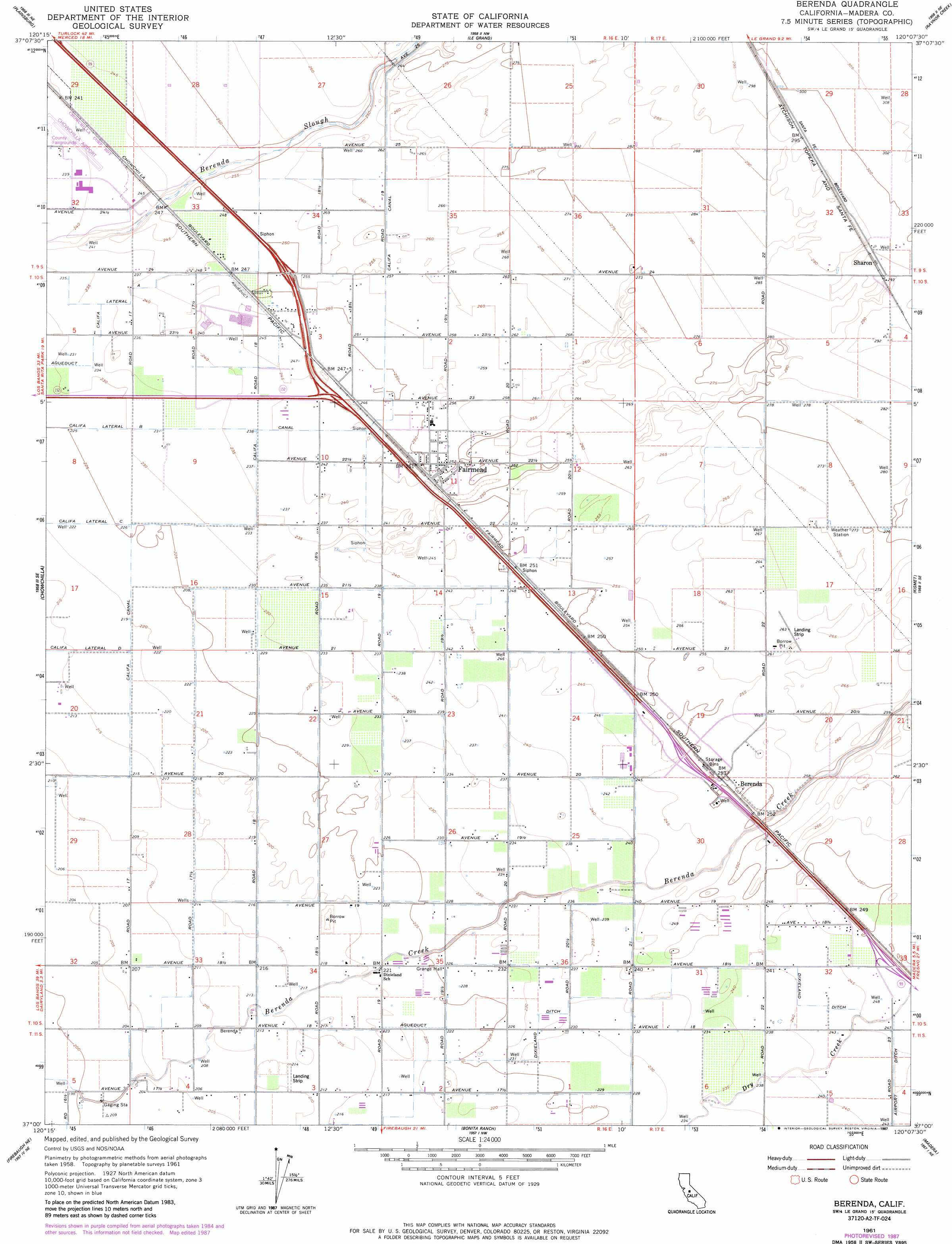
USGS Topo Quad 37120a2 - 1:24,000 scale
| Topo Map Name: | Berenda |
| USGS Topo Quad ID: | 37120a2 |
| Print Size: | ca. 21 1/4" wide x 27" high |
| Southeast Coordinates: | 37° N latitude / 120.125° W longitude |
| Map Center Coordinates: | 37.0625° N latitude / 120.1875° W longitude |
| U.S. State: | CA |
| Filename: | o37120a2.jpg |
| Download Map JPG Image: | Berenda topo map 1:24,000 scale |
| Map Type: | Topographic |
| Topo Series: | 7.5´ |
| Map Scale: | 1:24,000 |
| Source of Map Images: | United States Geological Survey (USGS) |
| Alternate Map Versions: |
Berenda CA 1948 Download PDF Buy paper map Berenda CA 1948 Download PDF Buy paper map Berenda CA 1961, updated 1962 Download PDF Buy paper map Berenda CA 1961, updated 1981 Download PDF Buy paper map Berenda CA 1961, updated 1981 Download PDF Buy paper map Berenda CA 1961, updated 1987 Download PDF Buy paper map Berenda CA 2012 Download PDF Buy paper map Berenda CA 2015 Download PDF Buy paper map |
1:24,000 Topo Quads surrounding Berenda
Merced |
Planada |
Owens Reservoir |
Illinois Hill |
Ben Hur |
El Nido |
Plainsburg |
Le Grand |
Raynor Creek |
Raymond |
Bliss Ranch |
Chowchilla |
Berenda |
Kismet |
Daulton |
Poso Farm |
Firebaugh Ne |
Bonita Ranch |
Madera |
Gregg |
Firebaugh |
Mendota Dam |
Gravelly Ford |
Biola |
Herndon |
> Back to 37120a1 at 1:100,000 scale
> Back to 37120a1 at 1:250,000 scale
> Back to U.S. Topo Maps home
Berenda topo map: Gazetteer
Berenda: Airports
Chowchilla Airport elevation 73m 239′Sallaberry Ranch Strip elevation 80m 262′
Berenda: Canals
Airport Road Lateral elevation 75m 246′Califa Lateral A elevation 72m 236′
Califa Lateral B elevation 69m 226′
Dixieland Ditch elevation 72m 236′
Berenda: Populated Places
Berenda elevation 77m 252′Califa (historical) elevation 76m 249′
Fairmead elevation 77m 252′
Sharon elevation 90m 295′
Berenda: Post Offices
Berenda Post Office (historical) elevation 77m 252′Berenda digital topo map on disk
Buy this Berenda topo map showing relief, roads, GPS coordinates and other geographical features, as a high-resolution digital map file on DVD: