Bear Valley Topo Map California
To zoom in, hover over the map of Bear Valley
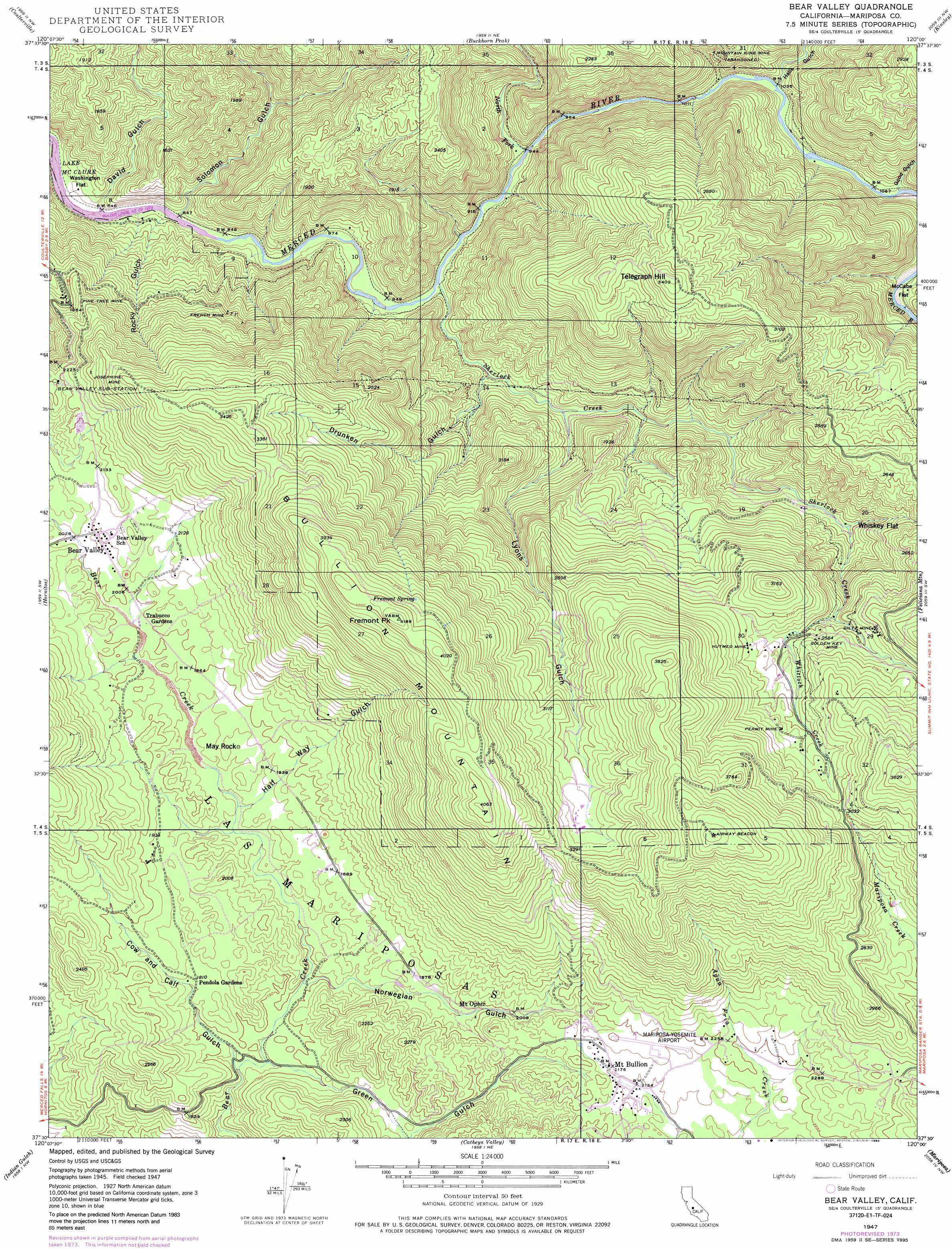
USGS Topo Quad 37120e1 - 1:24,000 scale
| Topo Map Name: | Bear Valley |
| USGS Topo Quad ID: | 37120e1 |
| Print Size: | ca. 21 1/4" wide x 27" high |
| Southeast Coordinates: | 37.5° N latitude / 120° W longitude |
| Map Center Coordinates: | 37.5625° N latitude / 120.0625° W longitude |
| U.S. State: | CA |
| Filename: | o37120e1.jpg |
| Download Map JPG Image: | Bear Valley topo map 1:24,000 scale |
| Map Type: | Topographic |
| Topo Series: | 7.5´ |
| Map Scale: | 1:24,000 |
| Source of Map Images: | United States Geological Survey (USGS) |
| Alternate Map Versions: |
Bear Valley CA 1947, updated 1968 Download PDF Buy paper map Bear Valley CA 1947, updated 1968 Download PDF Buy paper map Bear Valley CA 1947, updated 1976 Download PDF Buy paper map Bear Valley CA 1947, updated 1985 Download PDF Buy paper map Bear Valley CA 1947, updated 1995 Download PDF Buy paper map Bear Valley CA 1948 Download PDF Buy paper map Bear Valley CA 1948 Download PDF Buy paper map Bear Valley CA 2012 Download PDF Buy paper map Bear Valley CA 2015 Download PDF Buy paper map |
1:24,000 Topo Quads surrounding Bear Valley
Moccasin |
Groveland |
Jawbone Ridge |
Ascension Mountain |
Ackerson Mountain |
Penon Blanco Peak |
Coulterville |
Buckhorn Peak |
Kinsley |
El Portal |
Merced Falls |
Hornitos |
Bear Valley |
Feliciana Mountain |
Buckingham Mountain |
Haystack Mountain |
Indian Gulch |
Catheys Valley |
Mariposa |
Stumpfield Mountain |
Planada |
Owens Reservoir |
Illinois Hill |
Ben Hur |
Horsecamp Mountain |
> Back to 37120e1 at 1:100,000 scale
> Back to 37120a1 at 1:250,000 scale
> Back to U.S. Topo Maps home
Bear Valley topo map: Gazetteer
Bear Valley: Airports
Mariposa-Yosemite Airport elevation 675m 2214′Bear Valley: Flats
McCabe Flat elevation 339m 1112′Washington Flat elevation 260m 853′
Whiskey Flat elevation 517m 1696′
Bear Valley: Mines
Diltz Mine elevation 833m 2732′French Mine elevation 539m 1768′
Golden Key Mine elevation 787m 2582′
Josephine Mine elevation 776m 2545′
Mountain King Mine elevation 412m 1351′
Nutmeg Mine elevation 820m 2690′
Permit Mine elevation 872m 2860′
Pine Tree Mine elevation 605m 1984′
Bear Valley: Pillars
May Rock elevation 588m 1929′Bear Valley: Populated Places
Bear Valley elevation 626m 2053′Mount Bullion elevation 656m 2152′
Bear Valley: Springs
Fremont Spring elevation 1152m 3779′Bear Valley: Streams
North Fork Merced River elevation 284m 931′Sherlock Creek elevation 290m 951′
Whitlock Creek elevation 716m 2349′
Bear Valley: Summits
Bullion Knob elevation 1297m 4255′Bullion Mountain elevation 1272m 4173′
Fremont Peak elevation 1277m 4189′
Telegraph Hill elevation 1041m 3415′
Bear Valley: Valleys
Cow and Calf Gulch elevation 504m 1653′David Gulch elevation 252m 826′
Drunken Gulch elevation 332m 1089′
Good Gulch elevation 320m 1049′
Green Gulch elevation 517m 1696′
Half Way Gulch elevation 563m 1847′
Hall Gulch elevation 312m 1023′
Halls Gulch elevation 312m 1023′
Lyons Gulch elevation 348m 1141′
Norwegian Gulch elevation 533m 1748′
Rocky Gulch elevation 255m 836′
Solomon Gulch elevation 249m 816′
Bear Valley digital topo map on disk
Buy this Bear Valley topo map showing relief, roads, GPS coordinates and other geographical features, as a high-resolution digital map file on DVD: