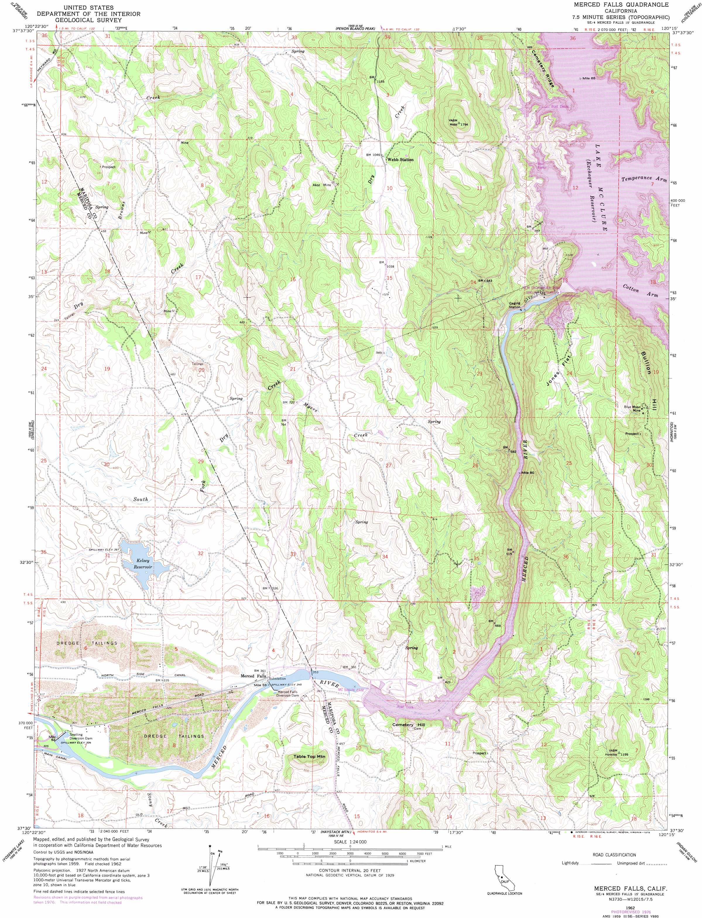
Merced Falls Topo Map California
To zoom in, hover over the map of Merced Falls
USGS Topo Quad 37120e3 - 1:24,000 scale
| Topo Map Name: | Merced Falls |
| USGS Topo Quad ID: | 37120e3 |
| Print Size: | ca. 21 1/4" wide x 27" high |
| Southeast Coordinates: | 37.5° N latitude / 120.25° W longitude |
| Map Center Coordinates: | 37.5625° N latitude / 120.3125° W longitude |
| U.S. State: | CA |
| Filename: | o37120e3.jpg |
| Download Map JPG Image: | Merced Falls topo map 1:24,000 scale |
| Map Type: | Topographic |
| Topo Series: | 7.5´ |
| Map Scale: | 1:24,000 |
| Source of Map Images: | United States Geological Survey (USGS) |
| Alternate Map Versions: |
Merced Falls CA 1916, updated 1957 Download PDF Buy paper map Merced Falls CA 1962, updated 1963 Download PDF Buy paper map Merced Falls CA 1962, updated 1978 Download PDF Buy paper map Merced Falls CA 2012 Download PDF Buy paper map Merced Falls CA 2015 Download PDF Buy paper map |
1:24,000 Topo Quads surrounding Merced Falls
Keystone |
Chinese Camp |
Moccasin |
Groveland |
Jawbone Ridge |
Cooperstown |
La Grange |
Penon Blanco Peak |
Coulterville |
Buckhorn Peak |
Turlock Lake |
Snelling |
Merced Falls |
Hornitos |
Bear Valley |
Winton |
Yosemite Lake |
Haystack Mountain |
Indian Gulch |
Catheys Valley |
Atwater |
Merced |
Planada |
Owens Reservoir |
Illinois Hill |
> Back to 37120e1 at 1:100,000 scale
> Back to 37120a1 at 1:250,000 scale
> Back to U.S. Topo Maps home
Merced Falls topo map: Gazetteer
Merced Falls: Bays
Temperance Arm elevation 251m 823′Merced Falls: Dams
Crocker Diversion 58-000 Dam elevation 92m 301′Kelsey 662 Dam elevation 121m 396′
Merced Falls Diversion Dam elevation 93m 305′
New Exchequer Dam elevation 251m 823′
New Exchequer Dam elevation 251m 823′
Snelling Diversion Dam elevation 93m 305′
Merced Falls: Flats
Jones Flat elevation 296m 971′Merced Falls: Mines
Akoz Mine elevation 308m 1010′Blue Moon Mine elevation 381m 1250′
Lucky Quartz Mine elevation 126m 413′
Merced Falls: Parks
McClure Point Recreation Area elevation 271m 889′Merced Falls: Populated Places
Merced Falls elevation 106m 347′Merced Falls: Reservoirs
Kelsey Reservoir elevation 121m 396′Lake McClure elevation 250m 820′
Merced Falls: Ridges
Cemetery Ridge elevation 280m 918′Merced Falls: Streams
Browns Creek elevation 111m 364′Myers Creek elevation 209m 685′
Stoney Creek elevation 93m 305′
Stony Creek elevation 93m 305′
Merced Falls: Summits
Bullion Hill elevation 454m 1489′Cemetery Hill elevation 191m 626′
Table Top Mountain elevation 199m 652′
Merced Falls digital topo map on disk
Buy this Merced Falls topo map showing relief, roads, GPS coordinates and other geographical features, as a high-resolution digital map file on DVD: