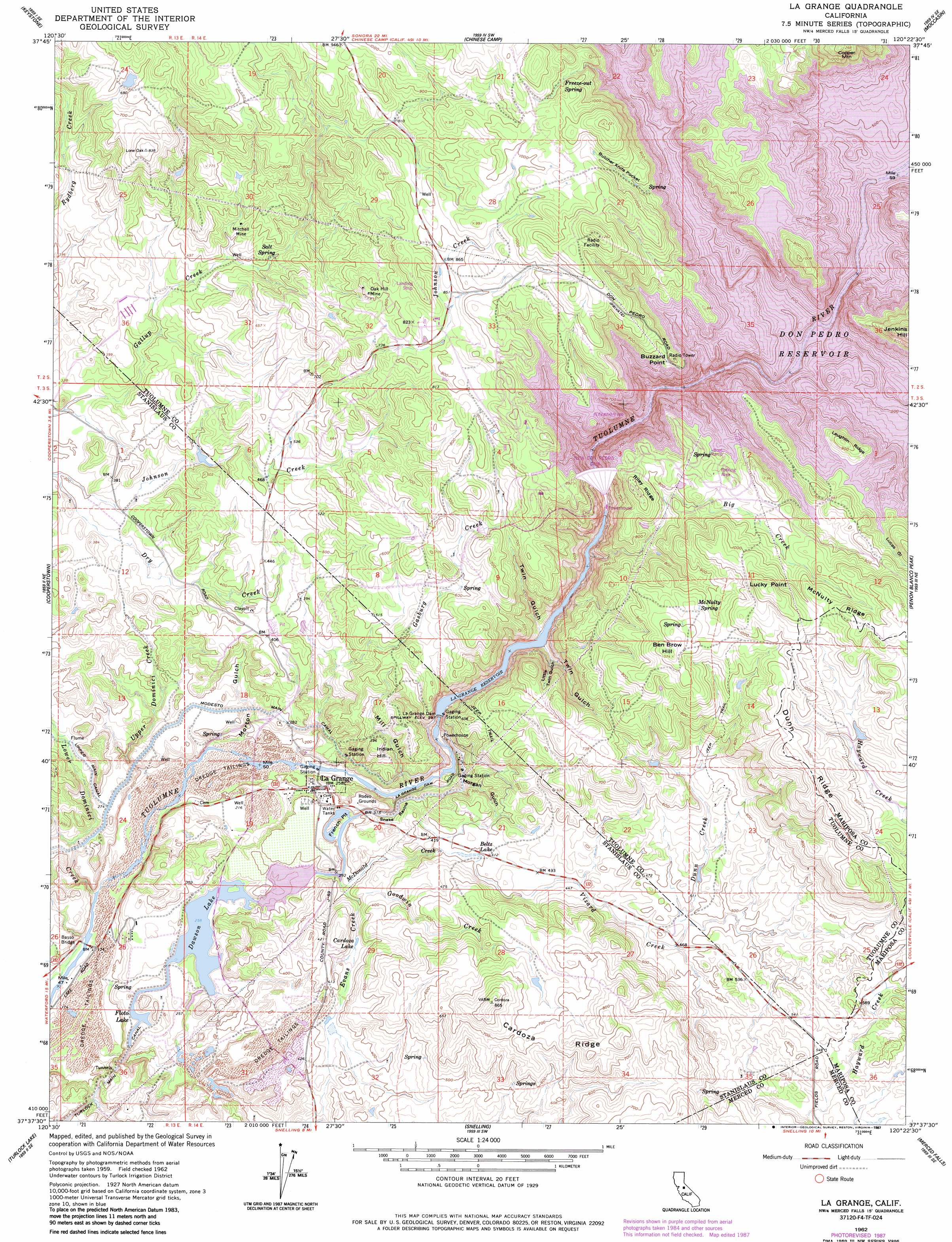
La Grange Topo Map California
To zoom in, hover over the map of La Grange
USGS Topo Quad 37120f4 - 1:24,000 scale
| Topo Map Name: | La Grange |
| USGS Topo Quad ID: | 37120f4 |
| Print Size: | ca. 21 1/4" wide x 27" high |
| Southeast Coordinates: | 37.625° N latitude / 120.375° W longitude |
| Map Center Coordinates: | 37.6875° N latitude / 120.4375° W longitude |
| U.S. State: | CA |
| Filename: | o37120f4.jpg |
| Download Map JPG Image: | La Grange topo map 1:24,000 scale |
| Map Type: | Topographic |
| Topo Series: | 7.5´ |
| Map Scale: | 1:24,000 |
| Source of Map Images: | United States Geological Survey (USGS) |
| Alternate Map Versions: |
La Grange CA 1915, updated 1957 Download PDF Buy paper map La Grange CA 1962, updated 1963 Download PDF Buy paper map La Grange CA 1962, updated 1972 Download PDF Buy paper map La Grange CA 1962, updated 1978 Download PDF Buy paper map La Grange CA 1962, updated 1987 Download PDF Buy paper map La Grange CA 2012 Download PDF Buy paper map La Grange CA 2015 Download PDF Buy paper map |
1:24,000 Topo Quads surrounding La Grange
Copperopolis |
New Melones Dam |
Sonora |
Standard |
Tuolumne |
Knights Ferry |
Keystone |
Chinese Camp |
Moccasin |
Groveland |
Paulsell |
Cooperstown |
La Grange |
Penon Blanco Peak |
Coulterville |
Montpelier |
Turlock Lake |
Snelling |
Merced Falls |
Hornitos |
Cressey |
Winton |
Yosemite Lake |
Haystack Mountain |
Indian Gulch |
> Back to 37120e1 at 1:100,000 scale
> Back to 37120a1 at 1:250,000 scale
> Back to U.S. Topo Maps home
La Grange topo map: Gazetteer
La Grange: Basins
French Pit elevation 94m 308′La Grange: Bridges
Basso Bridge elevation 48m 157′La Grange: Capes
Buzzard Point elevation 271m 889′La Grange: Dams
Dawson Lake 68-004 Dam elevation 79m 259′Don Pedro Dam (historical) elevation 245m 803′
La Grange Dam elevation 119m 390′
New Don Pedro Dam elevation 245m 803′
La Grange: Islands
Big Island (historical) elevation 245m 803′Eagle Island (historical) elevation 245m 803′
La Grange: Lakes
Beltz Lake elevation 122m 400′Cardoza Lake elevation 108m 354′
Floto Lake elevation 79m 259′
La Grange: Mines
Fortynine Mine (historical) elevation 245m 803′Mitchell Mine elevation 174m 570′
Oak Hill Mine elevation 228m 748′
La Grange: Parks
La Grange Regional Park elevation 58m 190′La Grange: Populated Places
La Grange elevation 76m 249′La Grange: Post Offices
La Grange Post Office elevation 76m 249′La Grange: Reservoirs
Dawson Lake elevation 80m 262′Don Pedro Reservoir elevation 245m 803′
La Grange Reservoir elevation 119m 390′
La Grange: Ridges
Cardoza Ridge elevation 223m 731′Dunn Ridge elevation 316m 1036′
Laughlin Ridge elevation 281m 921′
McNulty Ridge elevation 332m 1089′
Riley Ridge elevation 282m 925′
La Grange: Springs
Freeze-Out Spring elevation 313m 1026′McNulty Spring elevation 293m 961′
Salt Spring elevation 159m 521′
La Grange: Streams
Big Creek elevation 89m 291′Dunn Creek elevation 142m 465′
Evans Creek elevation 90m 295′
Gasburg Creek elevation 89m 291′
Goodwin Creek elevation 81m 265′
Lower Dominici Creek elevation 48m 157′
McDonald Creek elevation 86m 282′
Salt Spring Creek elevation 149m 488′
Upper Dominici Creek elevation 56m 183′
Vizard Creek elevation 131m 429′
La Grange: Summits
Ben Brow Hill elevation 324m 1062′Indian Hill elevation 126m 413′
Jenkins Hill elevation 362m 1187′
Lucky Point elevation 358m 1174′
La Grange: Valleys
Brush Gulch elevation 245m 803′Butcher Knife Pocket elevation 257m 843′
Frank Young Gulch elevation 245m 803′
Gillman Gulch elevation 245m 803′
Little Twin Gulch elevation 126m 413′
Lone Gulch elevation 245m 803′
Lucas Gulch elevation 245m 803′
Mexican Gulch elevation 245m 803′
Mill Gulch elevation 89m 291′
Morgan Gulch elevation 55m 180′
Morton Gulch elevation 56m 183′
Snake Ravine elevation 54m 177′
Twin Gulch elevation 89m 291′
Twin Gulch elevation 106m 347′
La Grange digital topo map on disk
Buy this La Grange topo map showing relief, roads, GPS coordinates and other geographical features, as a high-resolution digital map file on DVD: