Cooperstown Topo Map California
To zoom in, hover over the map of Cooperstown
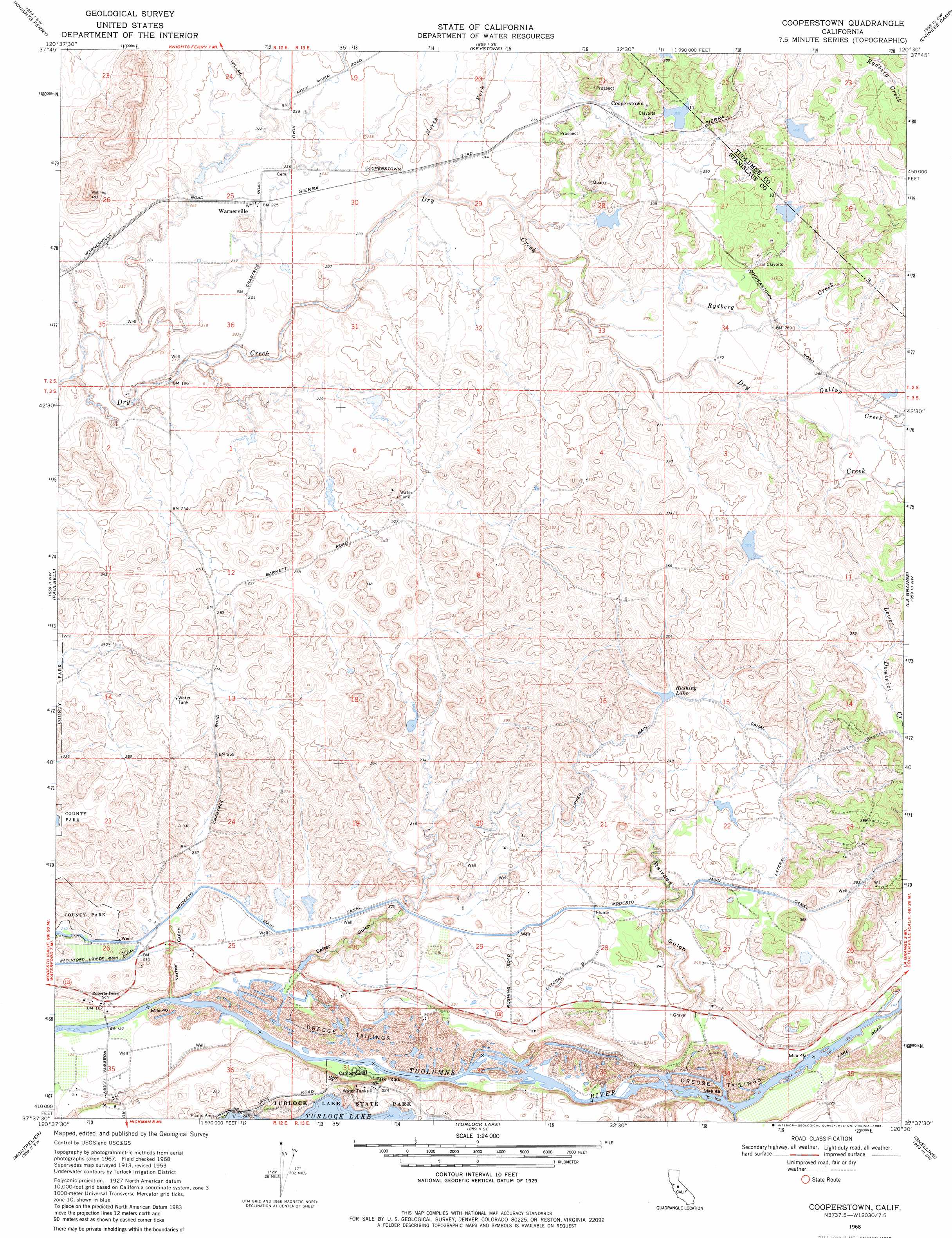
USGS Topo Quad 37120f5 - 1:24,000 scale
| Topo Map Name: | Cooperstown |
| USGS Topo Quad ID: | 37120f5 |
| Print Size: | ca. 21 1/4" wide x 27" high |
| Southeast Coordinates: | 37.625° N latitude / 120.5° W longitude |
| Map Center Coordinates: | 37.6875° N latitude / 120.5625° W longitude |
| U.S. State: | CA |
| Filename: | o37120f5.jpg |
| Download Map JPG Image: | Cooperstown topo map 1:24,000 scale |
| Map Type: | Topographic |
| Topo Series: | 7.5´ |
| Map Scale: | 1:24,000 |
| Source of Map Images: | United States Geological Survey (USGS) |
| Alternate Map Versions: |
Cooperstown CA 1953, updated 1955 Download PDF Buy paper map Cooperstown CA 1968, updated 1971 Download PDF Buy paper map Cooperstown CA 1968, updated 1971 Download PDF Buy paper map Cooperstown CA 1968, updated 1982 Download PDF Buy paper map Cooperstown CA 2012 Download PDF Buy paper map Cooperstown CA 2015 Download PDF Buy paper map |
1:24,000 Topo Quads surrounding Cooperstown
Bachelor Valley |
Copperopolis |
New Melones Dam |
Sonora |
Standard |
Oakdale |
Knights Ferry |
Keystone |
Chinese Camp |
Moccasin |
Waterford |
Paulsell |
Cooperstown |
La Grange |
Penon Blanco Peak |
Denair |
Montpelier |
Turlock Lake |
Snelling |
Merced Falls |
Turlock |
Cressey |
Winton |
Yosemite Lake |
Haystack Mountain |
> Back to 37120e1 at 1:100,000 scale
> Back to 37120a1 at 1:250,000 scale
> Back to U.S. Topo Maps home
Cooperstown topo map: Gazetteer
Cooperstown: Canals
Lateral A elevation 81m 265′Lateral B elevation 80m 262′
Upper Main Canal elevation 80m 262′
Cooperstown: Parks
Turlock Lake State Recreation Area elevation 83m 272′Cooperstown: Populated Places
Cooperstown elevation 84m 275′Warnerville elevation 70m 229′
Cooperstown: Reservoirs
Rushing Lake elevation 80m 262′Cooperstown: Streams
Gallup Creek elevation 83m 272′Johnson Creek elevation 92m 301′
North Fork Dry Creek elevation 64m 209′
Peaslee Creek elevation 45m 147′
Rydberg Creek elevation 67m 219′
Cooperstown: Valleys
Rairden Gulch elevation 46m 150′Salter Gulch elevation 44m 144′
Warner Gulch elevation 37m 121′
Cooperstown digital topo map on disk
Buy this Cooperstown topo map showing relief, roads, GPS coordinates and other geographical features, as a high-resolution digital map file on DVD: