Groveland Topo Map California
To zoom in, hover over the map of Groveland
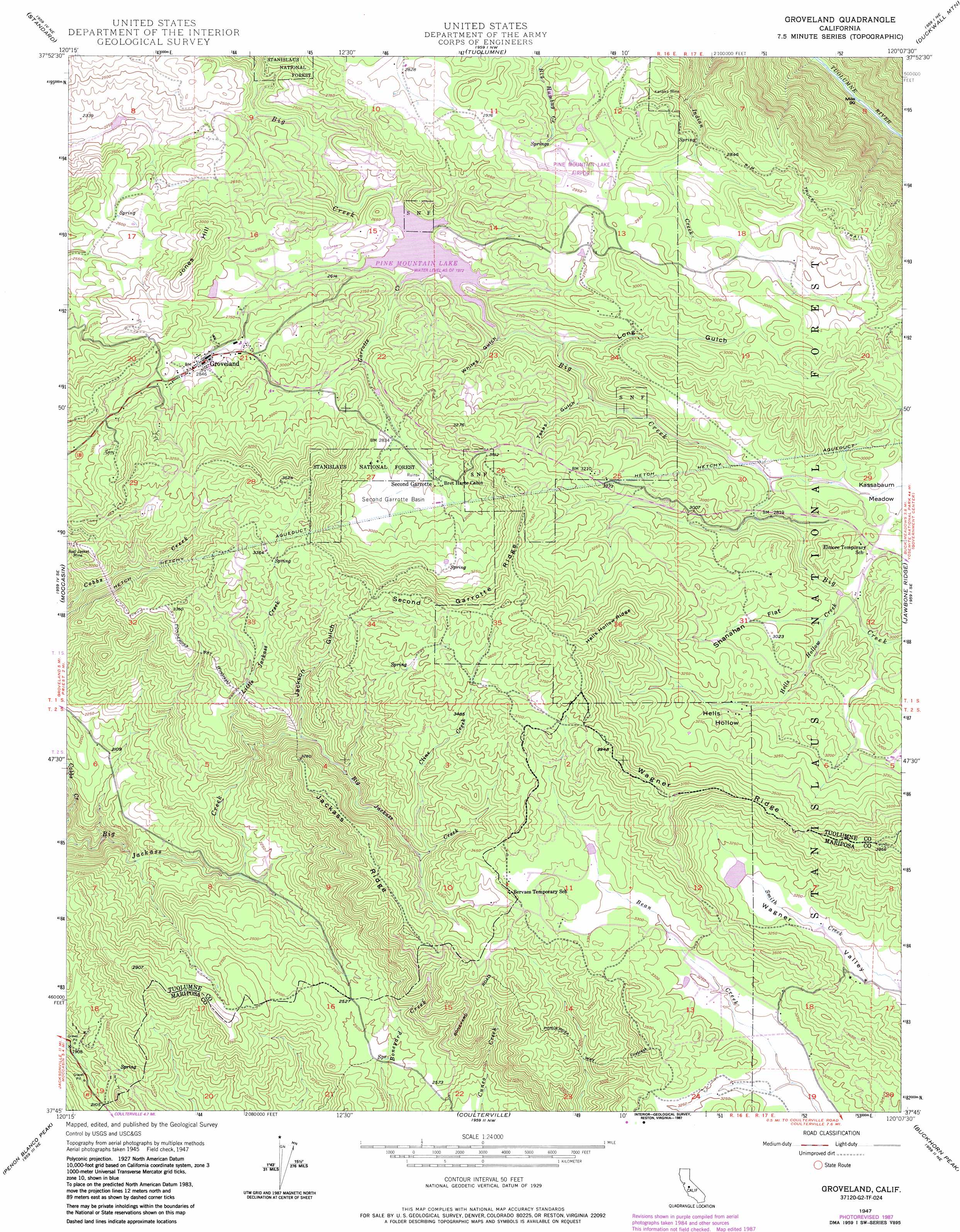
USGS Topo Quad 37120g2 - 1:24,000 scale
| Topo Map Name: | Groveland |
| USGS Topo Quad ID: | 37120g2 |
| Print Size: | ca. 21 1/4" wide x 27" high |
| Southeast Coordinates: | 37.75° N latitude / 120.125° W longitude |
| Map Center Coordinates: | 37.8125° N latitude / 120.1875° W longitude |
| U.S. State: | CA |
| Filename: | o37120g2.jpg |
| Download Map JPG Image: | Groveland topo map 1:24,000 scale |
| Map Type: | Topographic |
| Topo Series: | 7.5´ |
| Map Scale: | 1:24,000 |
| Source of Map Images: | United States Geological Survey (USGS) |
| Alternate Map Versions: |
Groveland CA 1947, updated 1964 Download PDF Buy paper map Groveland CA 1947, updated 1967 Download PDF Buy paper map Groveland CA 1947, updated 1976 Download PDF Buy paper map Groveland CA 1947, updated 1987 Download PDF Buy paper map Groveland CA 1949, updated 1949 Download PDF Buy paper map Groveland CA 2001, updated 2004 Download PDF Buy paper map Groveland CA 2012 Download PDF Buy paper map Groveland CA 2015 Download PDF Buy paper map |
| FStopo: | US Forest Service topo Groveland is available: Download FStopo PDF Download FStopo TIF |
1:24,000 Topo Quads surrounding Groveland
Columbia |
Columbia Se |
Twain Harte |
Hull Creek |
Cherry Lake North |
Sonora |
Standard |
Tuolumne |
Duckwall Mountain |
Cherry Lake South |
Chinese Camp |
Moccasin |
Groveland |
Jawbone Ridge |
Ascension Mountain |
La Grange |
Penon Blanco Peak |
Coulterville |
Buckhorn Peak |
Kinsley |
Snelling |
Merced Falls |
Hornitos |
Bear Valley |
Feliciana Mountain |
> Back to 37120e1 at 1:100,000 scale
> Back to 37120a1 at 1:250,000 scale
> Back to U.S. Topo Maps home
Groveland topo map: Gazetteer
Groveland: Airports
Pine Mountain Lake Airport elevation 885m 2903′Groveland: Basins
Second Garrotte Basin elevation 895m 2936′Groveland: Dams
Big Creek 557 Dam elevation 808m 2650′Green Valley 673 Dam elevation 994m 3261′
Groveland: Flats
Kassabaum Meadow elevation 881m 2890′Shanahan Flat elevation 927m 3041′
Groveland: Mines
Kanaka Mine elevation 805m 2641′Groveland: Parks
Groveland Wayside Park elevation 853m 2798′Groveland: Populated Places
Groveland elevation 869m 2851′Second Garrotte elevation 882m 2893′
Groveland: Reservoirs
Pine Mountain Lake elevation 808m 2650′Groveland: Ridges
Hells Hollow Ridge elevation 1176m 3858′Jackass Ridge elevation 1035m 3395′
Second Garrotte Ridge elevation 1123m 3684′
Wagner Ridge elevation 1159m 3802′
Groveland: Streams
Cline Creek elevation 920m 3018′Garrotte Creek elevation 791m 2595′
Hells Hollow Creek elevation 884m 2900′
Little Jackass Creek elevation 770m 2526′
Groveland: Summits
Jones Hill elevation 947m 3106′Groveland: Trails
Ponderosa Way elevation 922m 3024′Groveland: Valleys
Hells Hollow elevation 923m 3028′Jackson Gulch elevation 813m 2667′
Long Gulch elevation 797m 2614′
Texas Gulch elevation 816m 2677′
Whites Gulch elevation 810m 2657′
Groveland digital topo map on disk
Buy this Groveland topo map showing relief, roads, GPS coordinates and other geographical features, as a high-resolution digital map file on DVD: