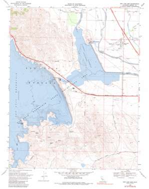
San Luis Dam Topo Map California
To zoom in, hover over the map of San Luis Dam
USGS Topo Quad 37121a1 - 1:24,000 scale
| Topo Map Name: | San Luis Dam |
| USGS Topo Quad ID: | 37121a1 |
| Print Size: | ca. 21 1/4" wide x 27" high |
| Southeast Coordinates: | 37° N latitude / 121° W longitude |
| Map Center Coordinates: | 37.0625° N latitude / 121.0625° W longitude |
| U.S. State: | CA |
| Filename: | o37121a1.jpg |
| Download Map JPG Image: | San Luis Dam topo map 1:24,000 scale |
| Map Type: | Topographic |
| Topo Series: | 7.5´ |
| Map Scale: | 1:24,000 |
| Source of Map Images: | United States Geological Survey (USGS) |
| Alternate Map Versions: |
San Luis Creek CA 1953, updated 1954 Download PDF Buy paper map San Luis Creek CA 1953, updated 1964 Download PDF Buy paper map San Luis Dam CA 1969, updated 1972 Download PDF Buy paper map San Luis Dam CA 1969, updated 1980 Download PDF Buy paper map San Luis Dam CA 1969, updated 1980 Download PDF Buy paper map San Luis Dam CA 2012 Download PDF Buy paper map San Luis Dam CA 2015 Download PDF Buy paper map |
1:24,000 Topo Quads surrounding San Luis Dam
> Back to 37121a1 at 1:100,000 scale
> Back to 37120a1 at 1:250,000 scale
> Back to U.S. Topo Maps home
San Luis Dam topo map: Gazetteer
San Luis Dam: Airports
Santa Nella Airport (historical) elevation 51m 167′San Luis Dam: Bays
Lone Oak Bay elevation 167m 547′San Luis Dam: Beaches
North Beach elevation 71m 232′South Beach elevation 71m 232′
San Luis Dam: Capes
Indian Point elevation 71m 232′Quien Sabe Point elevation 194m 636′
San Luis Dam: Dams
Oneill Dam elevation 55m 180′O'Neill Dam elevation 71m 232′
Oneill Forebay Dike Dam elevation 70m 229′
San Luis Dam elevation 167m 547′
San Luis Dike Dam elevation 70m 229′
San Luis Dam: Parks
Basalt Day Use Area elevation 174m 570′Lower Cottonwood Creek Wildlife Area elevation 175m 574′
O'Neill Forebay Wildlife Area elevation 59m 193′
San Luis Reservoir State Recreation Area elevation 167m 547′
San Luis Dam: Populated Places
Santa Nella Village elevation 47m 154′San Luis Dam: Reservoirs
O'Neill Forebay elevation 71m 232′San Luis Reservoir elevation 167m 547′
San Luis Dam: Springs
Domengine Spring elevation 193m 633′Willow Spring elevation 296m 971′
San Luis Dam: Streams
Romero Creek elevation 61m 200′San Luis Dam: Summits
Basalt Hill elevation 519m 1702′San Luis Dam digital topo map on disk
Buy this San Luis Dam topo map showing relief, roads, GPS coordinates and other geographical features, as a high-resolution digital map file on DVD:


