Pacheco Peak Topo Map California
To zoom in, hover over the map of Pacheco Peak
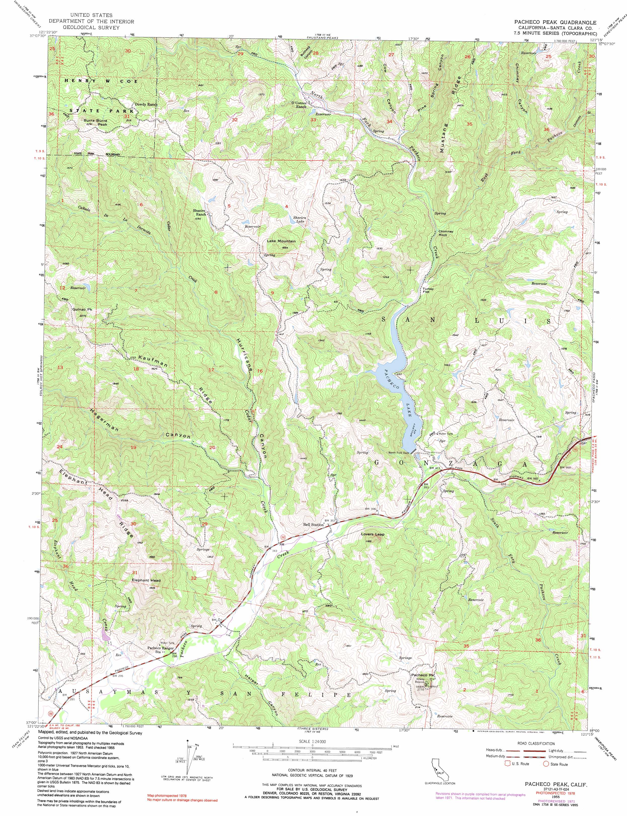
USGS Topo Quad 37121a3 - 1:24,000 scale
| Topo Map Name: | Pacheco Peak |
| USGS Topo Quad ID: | 37121a3 |
| Print Size: | ca. 21 1/4" wide x 27" high |
| Southeast Coordinates: | 37° N latitude / 121.25° W longitude |
| Map Center Coordinates: | 37.0625° N latitude / 121.3125° W longitude |
| U.S. State: | CA |
| Filename: | o37121a3.jpg |
| Download Map JPG Image: | Pacheco Peak topo map 1:24,000 scale |
| Map Type: | Topographic |
| Topo Series: | 7.5´ |
| Map Scale: | 1:24,000 |
| Source of Map Images: | United States Geological Survey (USGS) |
| Alternate Map Versions: |
Pacheco Peak CA 1955, updated 1957 Download PDF Buy paper map Pacheco Peak CA 1955, updated 1965 Download PDF Buy paper map Pacheco Peak CA 1955, updated 1972 Download PDF Buy paper map Pacheco Peak CA 1955, updated 1991 Download PDF Buy paper map Pacheco Peak CA 2012 Download PDF Buy paper map Pacheco Peak CA 2015 Download PDF Buy paper map |
1:24,000 Topo Quads surrounding Pacheco Peak
Isabel Valley |
Mount Stakes |
Wilcox Ridge |
Orestimba Peak |
Newman |
Mount Sizer |
Mississippi Creek |
Mustang Peak |
Crevison Peak |
Howard Ranch |
Gilroy |
Gilroy Hot Springs |
Pacheco Peak |
Pacheco Pass |
San Luis Dam |
Chittenden |
San Felipe |
Three Sisters |
Mariposa Peak |
Los Banos Valley |
San Juan Bautista |
Hollister |
Tres Pinos |
Quien Sabe Valley |
Ruby Canyon |
> Back to 37121a1 at 1:100,000 scale
> Back to 37120a1 at 1:250,000 scale
> Back to U.S. Topo Maps home
Pacheco Peak topo map: Gazetteer
Pacheco Peak: Dams
North Fork Dam elevation 145m 475′Pacheco Peak: Flats
Turkey Flat elevation 149m 488′Pacheco Peak: Lakes
Lake Mountain elevation 556m 1824′Shaeirn Lake elevation 378m 1240′
Pacheco Peak: Pillars
Chimney Rock elevation 163m 534′Pacheco Peak: Reservoirs
Pacheco Lake elevation 145m 475′Pacheco Peak: Ridges
Elephant Head Ridge elevation 590m 1935′Kaufman Ridge elevation 529m 1735′
Mustang Ridge elevation 402m 1318′
Pacheco Peak: Streams
Cañada De La Dormida elevation 218m 715′Cedar Creek elevation 99m 324′
Coon Creek elevation 206m 675′
East Fork Pacheco Creek elevation 182m 597′
Elephant Head Creek elevation 84m 275′
North Fork Pacheco Creek elevation 146m 479′
South Fork Pacheco Creek elevation 128m 419′
Pacheco Peak: Summits
Burra Burra Peak elevation 682m 2237′Elephant Head elevation 575m 1886′
Gulnac Peak elevation 686m 2250′
Lovers Leap elevation 317m 1040′
Pacheco Peak elevation 816m 2677′
Pacheco Peak: Valleys
Bullhead Canyon elevation 198m 649′Chimney Canyon elevation 243m 797′
Chimney Gulch elevation 282m 925′
Cow Canyon elevation 196m 643′
Harper Canyon elevation 95m 311′
Hurricane Canyon elevation 128m 419′
Pine Spring Canyon elevation 175m 574′
Pacheco Peak digital topo map on disk
Buy this Pacheco Peak topo map showing relief, roads, GPS coordinates and other geographical features, as a high-resolution digital map file on DVD: