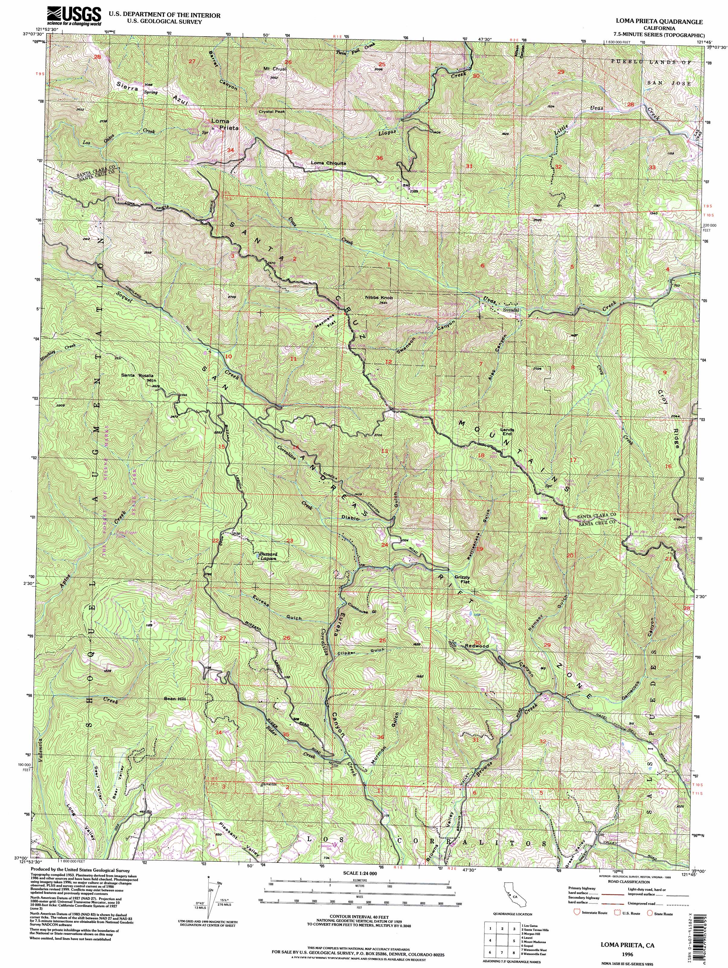
Loma Prieta Topo Map California
To zoom in, hover over the map of Loma Prieta
USGS Topo Quad 37121a7 - 1:24,000 scale
| Topo Map Name: | Loma Prieta |
| USGS Topo Quad ID: | 37121a7 |
| Print Size: | ca. 21 1/4" wide x 27" high |
| Southeast Coordinates: | 37° N latitude / 121.75° W longitude |
| Map Center Coordinates: | 37.0625° N latitude / 121.8125° W longitude |
| U.S. State: | CA |
| Filename: | o37121a7.jpg |
| Download Map JPG Image: | Loma Prieta topo map 1:24,000 scale |
| Map Type: | Topographic |
| Topo Series: | 7.5´ |
| Map Scale: | 1:24,000 |
| Source of Map Images: | United States Geological Survey (USGS) |
| Alternate Map Versions: |
Loma Prieta CA 1955, updated 1956 Download PDF Buy paper map Loma Prieta CA 1955, updated 1961 Download PDF Buy paper map Loma Prieta CA 1955, updated 1969 Download PDF Buy paper map Loma Prieta CA 1955, updated 1975 Download PDF Buy paper map Loma Prieta CA 1955, updated 1986 Download PDF Buy paper map Loma Prieta CA 1955, updated 1994 Download PDF Buy paper map Loma Prieta CA 1996, updated 1999 Download PDF Buy paper map Loma Prieta CA 2012 Download PDF Buy paper map Loma Prieta CA 2015 Download PDF Buy paper map |
1:24,000 Topo Quads surrounding Loma Prieta
Cupertino |
San Jose West |
San Jose East |
Lick Observatory |
Isabel Valley |
Castle Rock Ridge |
Los Gatos |
Santa Teresa Hills |
Morgan Hill |
Mount Sizer |
Felton |
Laurel |
Loma Prieta |
Mount Madonna |
Gilroy |
Santa Cruz |
Soquel |
Watsonville West |
Watsonville East |
Chittenden |
Moss Landing |
Prunedale |
San Juan Bautista |
> Back to 37121a1 at 1:100,000 scale
> Back to 37120a1 at 1:250,000 scale
> Back to U.S. Topo Maps home
Loma Prieta topo map: Gazetteer
Loma Prieta: Airports
Canyon Creek Heliport elevation 641m 2103′Loma Prieta: Falls
Basin Falls elevation 557m 1827′Black Rock Falls elevation 426m 1397′
Fiver Finger Falls elevation 246m 807′
Triple Falls elevation 498m 1633′
Upper Falls elevation 489m 1604′
Loma Prieta: Flats
Grizzly Flat elevation 331m 1085′Maymens Flat elevation 866m 2841′
Loma Prieta: Lakes
Buzzard Lagoon elevation 583m 1912′Loma Prieta: Parks
Uvas Canyon County Park elevation 504m 1653′Loma Prieta: Populated Places
Day Valley elevation 403m 1322′Mountain Home elevation 278m 912′
Sveadal elevation 318m 1043′
Loma Prieta: Ranges
Santa Cruz Mountains elevation 1136m 3727′Loma Prieta: Ridges
Croy Ridge elevation 619m 2030′Loma Prieta: Streams
Alec Creek elevation 270m 885′Croy Creek elevation 236m 774′
Rider Creek elevation 130m 426′
Loma Prieta: Summits
Bean Hill elevation 442m 1450′Crystal Peak elevation 1097m 3599′
Lands End elevation 780m 2559′
Loma Chiquita elevation 794m 2604′
Loma Prieta elevation 1136m 3727′
Mount Chual elevation 1046m 3431′
Nibbs Knob elevation 801m 2627′
Santa Rosalia Mountain elevation 788m 2585′
Loma Prieta: Trails
Cusacks Trail elevation 718m 2355′Loma Prieta: Valleys
Alec Canyon elevation 305m 1000′Bear Valley elevation 118m 387′
Clipper Gulch elevation 172m 564′
Cookhouse Gulch elevation 191m 626′
Deer Valley elevation 108m 354′
Diablo Gulch elevation 291m 954′
Eureka Gulch elevation 195m 639′
Gamecock Canyon elevation 178m 583′
Long Valley elevation 84m 275′
Mormon Gulch elevation 119m 390′
Ramsey Gulch elevation 171m 561′
Rattlesnake Gulch elevation 329m 1079′
Redwood Canyon elevation 158m 518′
Shingle Mill Gulch elevation 224m 734′
Swanson Canyon elevation 343m 1125′
Loma Prieta digital topo map on disk
Buy this Loma Prieta topo map showing relief, roads, GPS coordinates and other geographical features, as a high-resolution digital map file on DVD: