Copper Mountain Topo Map California
To zoom in, hover over the map of Copper Mountain
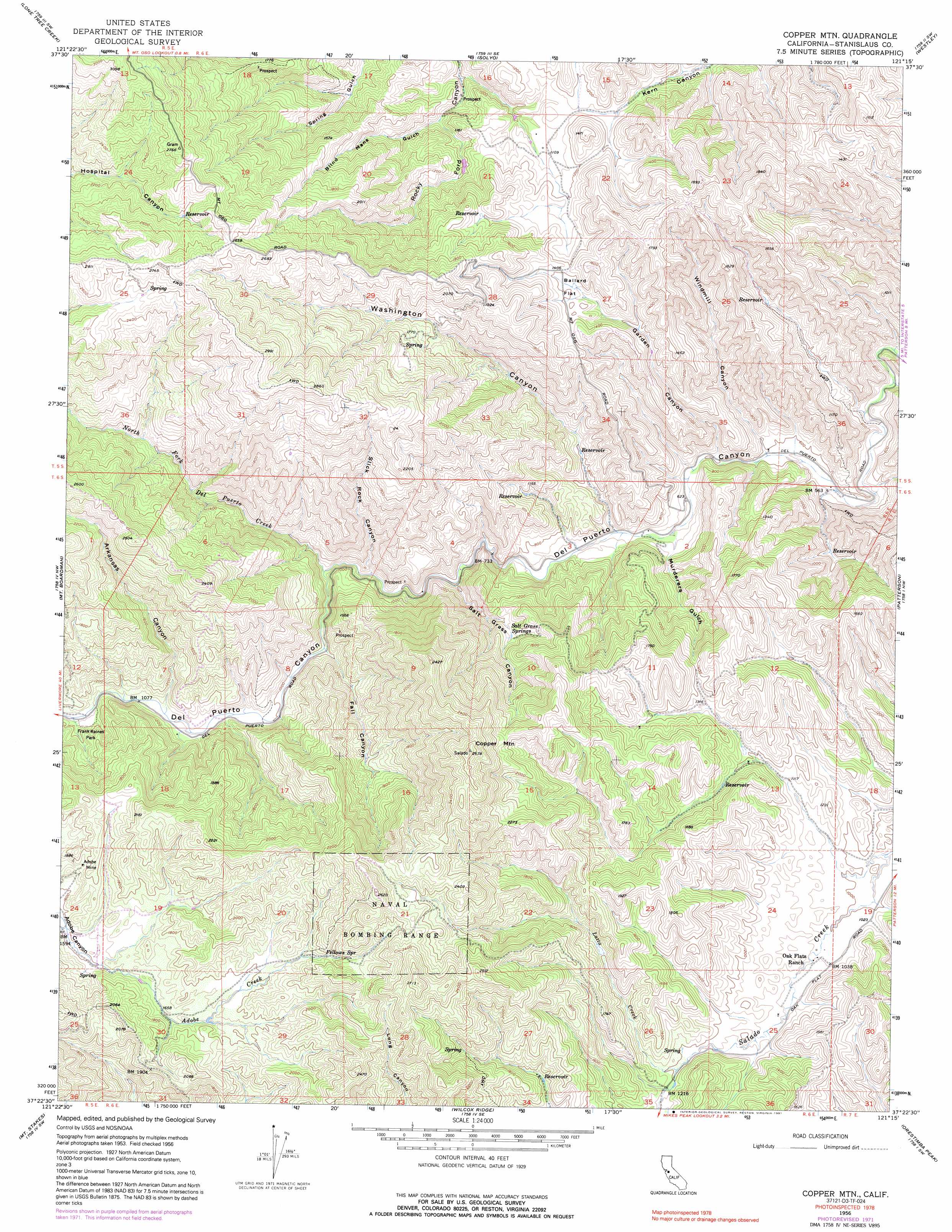
USGS Topo Quad 37121d3 - 1:24,000 scale
| Topo Map Name: | Copper Mountain |
| USGS Topo Quad ID: | 37121d3 |
| Print Size: | ca. 21 1/4" wide x 27" high |
| Southeast Coordinates: | 37.375° N latitude / 121.25° W longitude |
| Map Center Coordinates: | 37.4375° N latitude / 121.3125° W longitude |
| U.S. State: | CA |
| Filename: | o37121d3.jpg |
| Download Map JPG Image: | Copper Mountain topo map 1:24,000 scale |
| Map Type: | Topographic |
| Topo Series: | 7.5´ |
| Map Scale: | 1:24,000 |
| Source of Map Images: | United States Geological Survey (USGS) |
| Alternate Map Versions: |
Copper Mtn CA 1956, updated 1958 Download PDF Buy paper map Copper Mtn CA 1956, updated 1960 Download PDF Buy paper map Copper Mtn CA 1956, updated 1972 Download PDF Buy paper map Copper Mtn CA 1956, updated 1972 Download PDF Buy paper map Copper Mtn. CA 1956, updated 1991 Download PDF Buy paper map Copper Mtn CA 1956, updated 1991 Download PDF Buy paper map Copper Mountain CA 2012 Download PDF Buy paper map Copper Mountain CA 2015 Download PDF Buy paper map |
1:24,000 Topo Quads surrounding Copper Mountain
Midway |
Tracy |
Vernalis |
Ripon |
Salida |
Cedar Mountain |
Lone Tree Creek |
Solyo |
Westley |
Brush Lake |
Eylar Mountain |
Mount Boardman |
Copper Mountain |
Patterson |
Crows Landing |
Isabel Valley |
Mount Stakes |
Wilcox Ridge |
Orestimba Peak |
Newman |
Mount Sizer |
Mississippi Creek |
Mustang Peak |
Crevison Peak |
Howard Ranch |
> Back to 37121a1 at 1:100,000 scale
> Back to 37120a1 at 1:250,000 scale
> Back to U.S. Topo Maps home
Copper Mountain topo map: Gazetteer
Copper Mountain: Flats
Adobe Flat elevation 503m 1650′Ballard Flat elevation 416m 1364′
Copper Mountain: Mines
Adobe Mine elevation 529m 1735′Copper Mountain: Parks
Frank Raines Park elevation 344m 1128′Copper Mountain: Springs
Fellows Spring elevation 585m 1919′Salt Grass Springs elevation 386m 1266′
Copper Mountain: Streams
Falls Creek elevation 303m 994′Garden Canyon Creek elevation 194m 636′
Lotta Creek elevation 364m 1194′
North Fork Del Puerto Creek elevation 273m 895′
Copper Mountain: Summits
Copper Mountain elevation 807m 2647′Copper Mountain: Valleys
Arkansas Canyon elevation 320m 1049′Blind Mans Gulch elevation 282m 925′
Fall Canyon elevation 301m 987′
Garden Canyon elevation 183m 600′
Murderers Gulch elevation 196m 643′
Salt Grass Canyon elevation 249m 816′
Slick Rock Canyon elevation 256m 839′
Washington Canyon elevation 206m 675′
Windmill Canyon elevation 176m 577′
Copper Mountain digital topo map on disk
Buy this Copper Mountain topo map showing relief, roads, GPS coordinates and other geographical features, as a high-resolution digital map file on DVD: