Tracy Topo Map California
To zoom in, hover over the map of Tracy
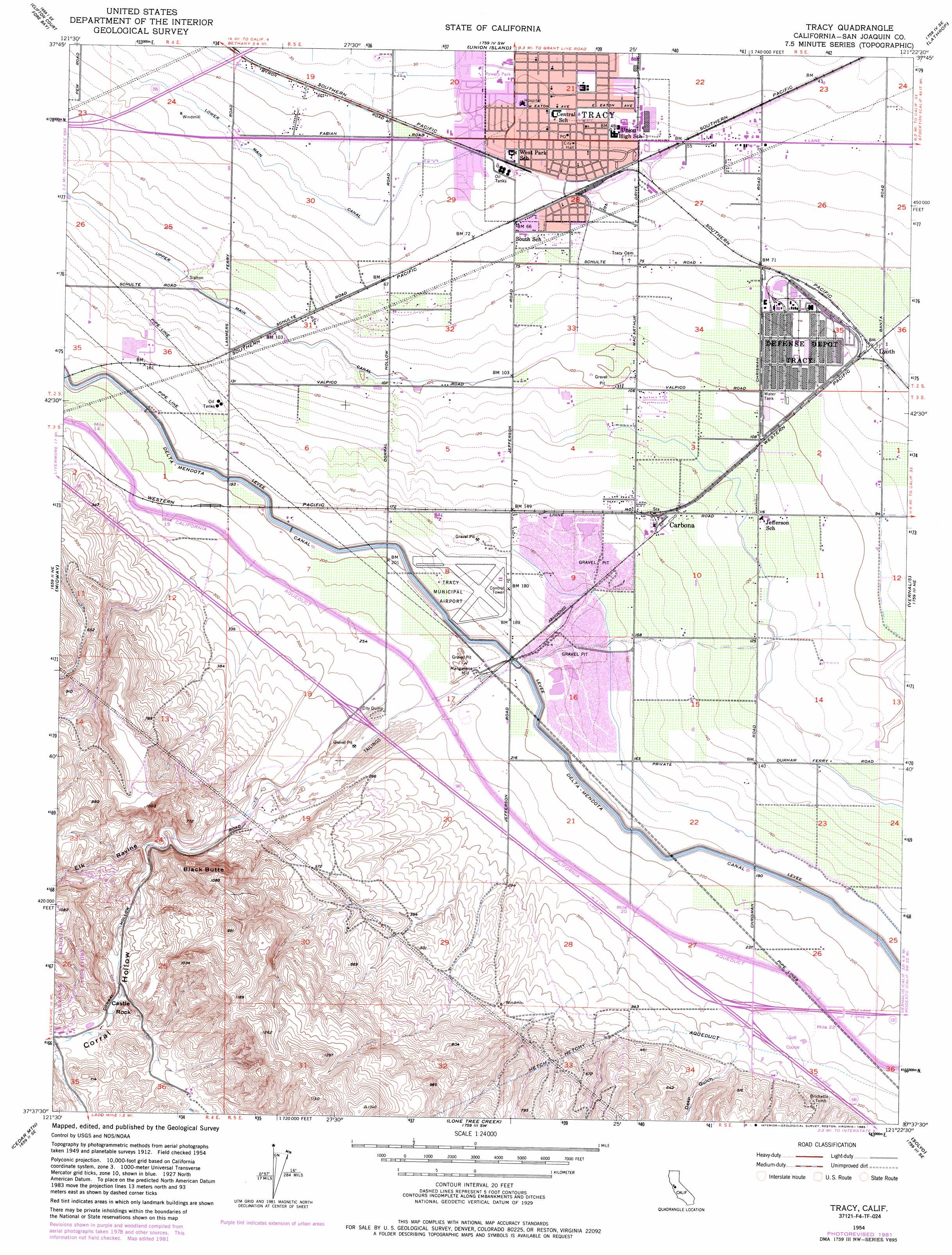
USGS Topo Quad 37121f4 - 1:24,000 scale
| Topo Map Name: | Tracy |
| USGS Topo Quad ID: | 37121f4 |
| Print Size: | ca. 21 1/4" wide x 27" high |
| Southeast Coordinates: | 37.625° N latitude / 121.375° W longitude |
| Map Center Coordinates: | 37.6875° N latitude / 121.4375° W longitude |
| U.S. State: | CA |
| Filename: | o37121f4.jpg |
| Download Map JPG Image: | Tracy topo map 1:24,000 scale |
| Map Type: | Topographic |
| Topo Series: | 7.5´ |
| Map Scale: | 1:24,000 |
| Source of Map Images: | United States Geological Survey (USGS) |
| Alternate Map Versions: |
Tracy CA 1954, updated 1955 Download PDF Buy paper map Tracy CA 1954, updated 1965 Download PDF Buy paper map Tracy CA 1954, updated 1969 Download PDF Buy paper map Tracy CA 1954, updated 1979 Download PDF Buy paper map Tracy CA 1954, updated 1982 Download PDF Buy paper map Tracy CA 1954, updated 1985 Download PDF Buy paper map Tracy CA 2012 Download PDF Buy paper map Tracy CA 2015 Download PDF Buy paper map |
1:24,000 Topo Quads surrounding Tracy
Brentwood |
Woodward Island |
Holt |
Stockton West |
Stockton East |
Byron Hot Springs |
Clifton Court Forebay |
Union Island |
Lathrop |
Manteca |
Altamont |
Midway |
Tracy |
Vernalis |
Ripon |
Mendenhall Springs |
Cedar Mountain |
Lone Tree Creek |
Solyo |
Westley |
Mount Day |
Eylar Mountain |
Mount Boardman |
Copper Mountain |
Patterson |
> Back to 37121e1 at 1:100,000 scale
> Back to 37120a1 at 1:250,000 scale
> Back to U.S. Topo Maps home
Tracy topo map: Gazetteer
Tracy: Airports
Tracy Municipal Airport elevation 55m 180′Tracy: Canals
Lateral Five West elevation 37m 121′Lateral Four West elevation 31m 101′
Tracy: Parks
Alden Park elevation 17m 55′Ceciliani Park elevation 17m 55′
Fabian Park elevation 12m 39′
Fine Park elevation 14m 45′
Harvest Park elevation 17m 55′
Huck Park elevation 19m 62′
Kelly Park elevation 9m 29′
Kit Fox Park elevation 15m 49′
Lincoln Park elevation 14m 45′
MacDonald Park elevation 20m 65′
Mount Diablo Park elevation 26m 85′
Mount Oso Park elevation 28m 91′
Powers Park elevation 12m 39′
South School Park elevation 22m 72′
Stevens Park elevation 21m 68′
Valley Oak Park elevation 23m 75′
Tracy: Pillars
Castle Rock elevation 199m 652′Tracy: Populated Places
Carbona elevation 41m 134′Ellis (historical) elevation 24m 78′
Lyoth elevation 24m 78′
Tracy elevation 16m 52′
Wainwright Village elevation 16m 52′
Tracy: Post Offices
Tracy Post Office elevation 16m 52′Tracy: Streams
Corral Hollow Creek elevation 60m 196′Tracy: Summits
Black Butte elevation 331m 1085′Tracy: Valleys
Corral Hollow elevation 121m 396′Deep Gulch elevation 94m 308′
Elk Ravine elevation 129m 423′
Tracy digital topo map on disk
Buy this Tracy topo map showing relief, roads, GPS coordinates and other geographical features, as a high-resolution digital map file on DVD: