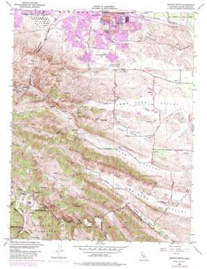
Antioch South Topo Map California
To zoom in, hover over the map of Antioch South
USGS Topo Quad 37121h7 - 1:24,000 scale
| Topo Map Name: | Antioch South |
| USGS Topo Quad ID: | 37121h7 |
| Print Size: | ca. 21 1/4" wide x 27" high |
| Southeast Coordinates: | 37.875° N latitude / 121.75° W longitude |
| Map Center Coordinates: | 37.9375° N latitude / 121.8125° W longitude |
| U.S. State: | CA |
| Filename: | o37121h7.jpg |
| Download Map JPG Image: | Antioch South topo map 1:24,000 scale |
| Map Type: | Topographic |
| Topo Series: | 7.5´ |
| Map Scale: | 1:24,000 |
| Source of Map Images: | United States Geological Survey (USGS) |
| Alternate Map Versions: |
Antioch South CA 1953, updated 1954 Download PDF Buy paper map Antioch South CA 1953, updated 1963 Download PDF Buy paper map Antioch South CA 1953, updated 1969 Download PDF Buy paper map Antioch South CA 1953, updated 1969 Download PDF Buy paper map Antioch South CA 1953, updated 1969 Download PDF Buy paper map Antioch South CA 1953, updated 1975 Download PDF Buy paper map Antioch South CA 1953, updated 1980 Download PDF Buy paper map Antioch South CA 1953, updated 1980 Download PDF Buy paper map Antioch South CA 1953, updated 1984 Download PDF Buy paper map Antioch South CA 2012 Download PDF Buy paper map Antioch South CA 2015 Download PDF Buy paper map |
1:24,000 Topo Quads surrounding Antioch South
> Back to 37121e1 at 1:100,000 scale
> Back to 37120a1 at 1:250,000 scale
> Back to U.S. Topo Maps home
Antioch South topo map: Gazetteer
Antioch South: Crossings
Exit 27A elevation 13m 42′Exit 27B elevation 18m 59′
Exit 28 elevation 18m 59′
Exit 29 elevation 13m 42′
Antioch South: Dams
Antioch Reservoir 3-000 Dam elevation 52m 170′Contra Loma Dam elevation 49m 160′
Contra Loma Dike Number 2 Dam elevation 48m 157′
Deer Creek 1007-003 Dam elevation 57m 187′
Antioch South: Flats
Sidney Flat elevation 140m 459′Antioch South: Gaps
Nortonville Pass elevation 340m 1115′Antioch South: Mines
Star Mine elevation 133m 436′Antioch South: Parks
Antioch Community Park elevation 43m 141′Canal Park elevation 45m 147′
Chichibu Park elevation 31m 101′
Gentrytown Park elevation 24m 78′
Harbour Park elevation 30m 98′
Hillcrest Park elevation 50m 164′
Memorial Park elevation 64m 209′
Mira Vista Hills Park elevation 52m 170′
Mira Vista Park elevation 36m 118′
Mountaire Park elevation 30m 98′
Prewett Family Park elevation 69m 226′
Sunny Ridge Park elevation 32m 104′
Village East Park elevation 26m 85′
Williamson Ranch Park elevation 43m 141′
Antioch South: Populated Places
Marsh Creek Springs elevation 178m 583′Neroly elevation 23m 75′
Newlove elevation 23m 75′
Somersville elevation 226m 741′
Stewartville elevation 170m 557′
West Hartley elevation 134m 439′
Antioch South: Post Offices
Antioch Post Office elevation 19m 62′Antioch South: Reservoirs
Antioch Municipal Reservoir elevation 52m 170′Contra Loma Reservoir elevation 48m 157′
Contra Loma Reservoir elevation 49m 160′
Contra Loma Reservoir elevation 59m 193′
Antioch South: Streams
Oil Creek elevation 132m 433′Sycamore Creek elevation 129m 423′
Antioch South: Tunnels
Coal Mine Tunnels elevation 146m 479′Antioch South: Valleys
Curry Canyon elevation 227m 744′Dark Canyon elevation 140m 459′
Deer Valley elevation 84m 275′
Hog Canyon elevation 125m 410′
Horse Valley elevation 60m 196′
Long Canyon elevation 127m 416′
Long Valley elevation 149m 488′
Markley Canyon elevation 54m 177′
Oil Canyon elevation 158m 518′
Perkins Canyon elevation 195m 639′
San Joaquin Valley elevation 111m 364′
Antioch South digital topo map on disk
Buy this Antioch South topo map showing relief, roads, GPS coordinates and other geographical features, as a high-resolution digital map file on DVD:


