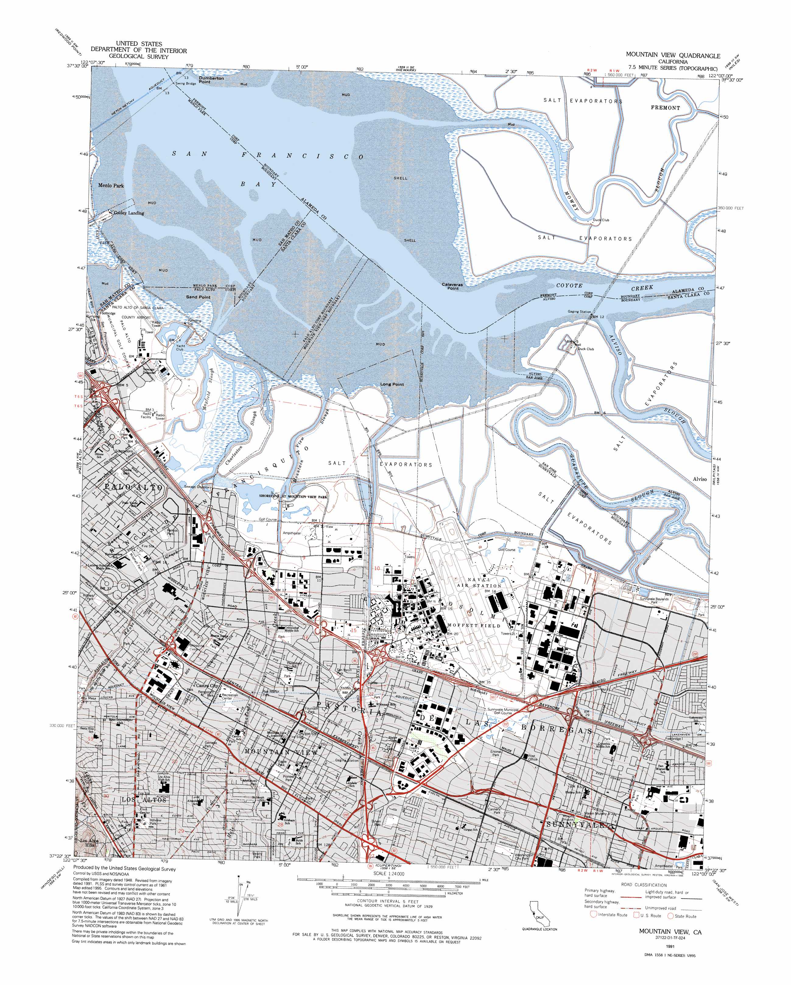
Mountain View Topo Map California
To zoom in, hover over the map of Mountain View
USGS Topo Quad 37122d1 - 1:24,000 scale
| Topo Map Name: | Mountain View |
| USGS Topo Quad ID: | 37122d1 |
| Print Size: | ca. 21 1/4" wide x 27" high |
| Southeast Coordinates: | 37.375° N latitude / 122° W longitude |
| Map Center Coordinates: | 37.4375° N latitude / 122.0625° W longitude |
| U.S. State: | CA |
| Filename: | o37122d1.jpg |
| Download Map JPG Image: | Mountain View topo map 1:24,000 scale |
| Map Type: | Topographic |
| Topo Series: | 7.5´ |
| Map Scale: | 1:24,000 |
| Source of Map Images: | United States Geological Survey (USGS) |
| Alternate Map Versions: |
Mountain View CA 1953, updated 1955 Download PDF Buy paper map Mountain View CA 1953, updated 1959 Download PDF Buy paper map Mountain View CA 1961, updated 1961 Download PDF Buy paper map Mountain View CA 1961, updated 1962 Download PDF Buy paper map Mountain View CA 1961, updated 1966 Download PDF Buy paper map Mountain View CA 1961, updated 1975 Download PDF Buy paper map Mountain View CA 1961, updated 1981 Download PDF Buy paper map Mountain View CA 1991, updated 1995 Download PDF Buy paper map Mountain View CA 1991, updated 1996 Download PDF Buy paper map Mountain View CA 1997, updated 1999 Download PDF Buy paper map Mountain View CA 2012 Download PDF Buy paper map Mountain View CA 2015 Download PDF Buy paper map |
1:24,000 Topo Quads surrounding Mountain View
Hunters Point |
San Leandro |
Hayward |
Dublin |
Livermore |
San Mateo |
Redwood Point |
Newark |
Niles |
La Costa Valley |
Woodside |
Palo Alto |
Mountain View |
Milpitas |
Calaveras Reservoir |
La Honda |
Mindego Hill |
Cupertino |
San Jose West |
San Jose East |
Franklin Point |
Big Basin |
Castle Rock Ridge |
Los Gatos |
Santa Teresa Hills |
> Back to 37122a1 at 1:100,000 scale
> Back to 37122a1 at 1:250,000 scale
> Back to U.S. Topo Maps home
Mountain View topo map: Gazetteer
Mountain View: Airports
Palo Alto Airport of Santa Clara County elevation 2m 6′Mountain View: Bays
Casey Forebay elevation 2m 6′Mountain View: Canals
Matadero Canal elevation 4m 13′Mountain View: Capes
Calaveras Point elevation 0m 0′Hooks Point elevation 1m 3′
Long Point elevation 1m 3′
Mountain View: Channels
Moffett Channel elevation 1m 3′Mountain View: Crossings
Exit 1A elevation 36m 118′Exit 1B elevation 33m 108′
Exit 1C elevation 33m 108′
Exit 2 elevation 21m 68′
Exit 22A elevation 42m 137′
Exit 22B elevation 40m 131′
Exit 22C elevation 36m 118′
Exit 23 elevation 27m 88′
Exit 24A elevation 16m 52′
Exit 24B elevation 12m 39′
Exit 395 elevation 12m 39′
Exit 396A elevation 15m 49′
Exit 396B elevation 16m 52′
Exit 397 elevation 17m 55′
Exit 398A elevation 13m 42′
Exit 398B elevation 11m 36′
Exit 399 elevation 13m 42′
Exit 3B elevation 15m 49′
Exit 4 elevation 4m 13′
Exit 400A elevation 5m 16′
Exit 400B elevation 4m 13′
Exit 400C elevation 4m 13′
Exit 402 elevation 3m 9′
Mountain View: Guts
Alviso Slough elevation 0m 0′Charleston Slough elevation 0m 0′
Devils Slough elevation 1m 3′
Guadalupe Slough elevation 1m 3′
Jogel Slough elevation 0m 0′
Mayfield Slough elevation 2m 6′
Mountain View Slough elevation 1m 3′
Mowry Slough elevation 0m 0′
Mountain View: Parks
Baylands Park elevation 0m 0′Bubb Park elevation 38m 124′
Cannery Park elevation 28m 91′
Columbia Park elevation 10m 32′
Crittenden School Park elevation 10m 32′
Cubberley Playground elevation 7m 22′
Cubberly Playground elevation 7m 22′
Eagle Park elevation 29m 95′
Encinal Park elevation 21m 68′
Fairoaks Park elevation 14m 45′
Graham School Park elevation 37m 121′
Greendell Playground elevation 6m 19′
Hillview Park elevation 54m 177′
Jellick Field elevation 33m 108′
Lakewood Park elevation 6m 19′
Lincoln Park elevation 60m 196′
Martin Murphy Junior Park elevation 22m 72′
Mayfield Park elevation 11m 36′
McKelvey Park elevation 33m 108′
Mitchell Park elevation 6m 19′
Monroe Mini Park elevation 18m 59′
Monta Loma School Park elevation 10m 32′
Mountain View Recreation Center elevation 19m 62′
Mountain View Sports Pavillion elevation 38m 124′
Ohlone Playground elevation 6m 19′
Orchard Park elevation 9m 29′
Pioneer Park elevation 28m 91′
Ramos Park elevation 3m 9′
Rengstorff Park elevation 20m 65′
Rex Manor Playground elevation 17m 55′
San Vernon Park elevation 16m 52′
San Veron Park elevation 16m 52′
Shoup Park elevation 61m 200′
Slater School Park elevation 25m 82′
Stevens Creek Shoreline Nature Study Area elevation 1m 3′
Stevenson School Park elevation 14m 45′
Sylvan Park elevation 21m 68′
Twin Creeks Sports Complex elevation 3m 9′
Washington Park elevation 33m 108′
Whisman School Park elevation 18m 59′
Wilbur Playground elevation 6m 19′
Mountain View: Populated Places
Adobe Meadow elevation 4m 13′Cape Cod Village Mobile Home Park elevation 8m 26′
Castro City elevation 18m 59′
Charleston Gardens elevation 5m 16′
Charleston Meadows elevation 13m 42′
Cooley Landing elevation 6m 19′
Cuesta Park elevation 39m 127′
El Dorado Mobile Home Park elevation 6m 19′
Fairoaks Mobile Home Park elevation 10m 32′
Fox Hollow Mobile Home Park elevation 4m 13′
Garcia Avenue Mobile Home Park elevation 25m 82′
Gemello elevation 31m 101′
Greenmeadow elevation 8m 26′
Jackson Park elevation 20m 65′
Los Altos elevation 48m 157′
Mary Manor Mobile Estates elevation 29m 95′
Meadow Park elevation 4m 13′
Mobiland Manor Mobile Home Park elevation 10m 32′
Moffett Trailer Village elevation 11m 36′
Monroe Park elevation 15m 49′
Monta Loma elevation 9m 29′
Mountain View elevation 32m 104′
New Frontier Mobile Home Park elevation 16m 52′
Palo Alto Orchards elevation 16m 52′
Palo Verde elevation 3m 9′
Plaza del Rey Mobile Home Park elevation 5m 16′
Rex Manor elevation 13m 42′
Sahara Village Mobile Home Park elevation 41m 134′
Saint Claire Gardens elevation 5m 16′
Saint Francis Acres elevation 33m 108′
Santiago Villa Mobile Home Park elevation 6m 19′
South Shore Port elevation 0m 0′
Sunset Estates Mobile Home Park elevation 18m 59′
Sylvan Park elevation 37m 121′
The Crossings elevation 15m 49′
The Greenhouse elevation 5m 16′
Travelodge Mobile Home Park elevation 18m 59′
Willow Ranch Mobile Home Park elevation 6m 19′
Mountain View: Post Offices
Los Altos Post Office elevation 57m 187′Mountain View Post Office elevation 24m 78′
Mountain View: Reservoirs
Shoreline Lake elevation -2m -7′Mountain View: Streams
Adobe Creek elevation 0m 0′Barron Creek elevation 2m 6′
Coyote Creek elevation 0m 0′
Hale Creek elevation 35m 114′
Permanente Creek elevation 0m 0′
San Francisquito Creek elevation 1m 3′
Stevens Creek elevation 1m 3′
Mountain View: Swamps
Crittenden Marsh elevation -3m -10′Mountain View Tidal Marsh elevation 2m 6′
Stevens Creek Tidal Marsh elevation -1m -4′
Mountain View digital topo map on disk
Buy this Mountain View topo map showing relief, roads, GPS coordinates and other geographical features, as a high-resolution digital map file on DVD: