San Francisco South Topo Map California
To zoom in, hover over the map of San Francisco South
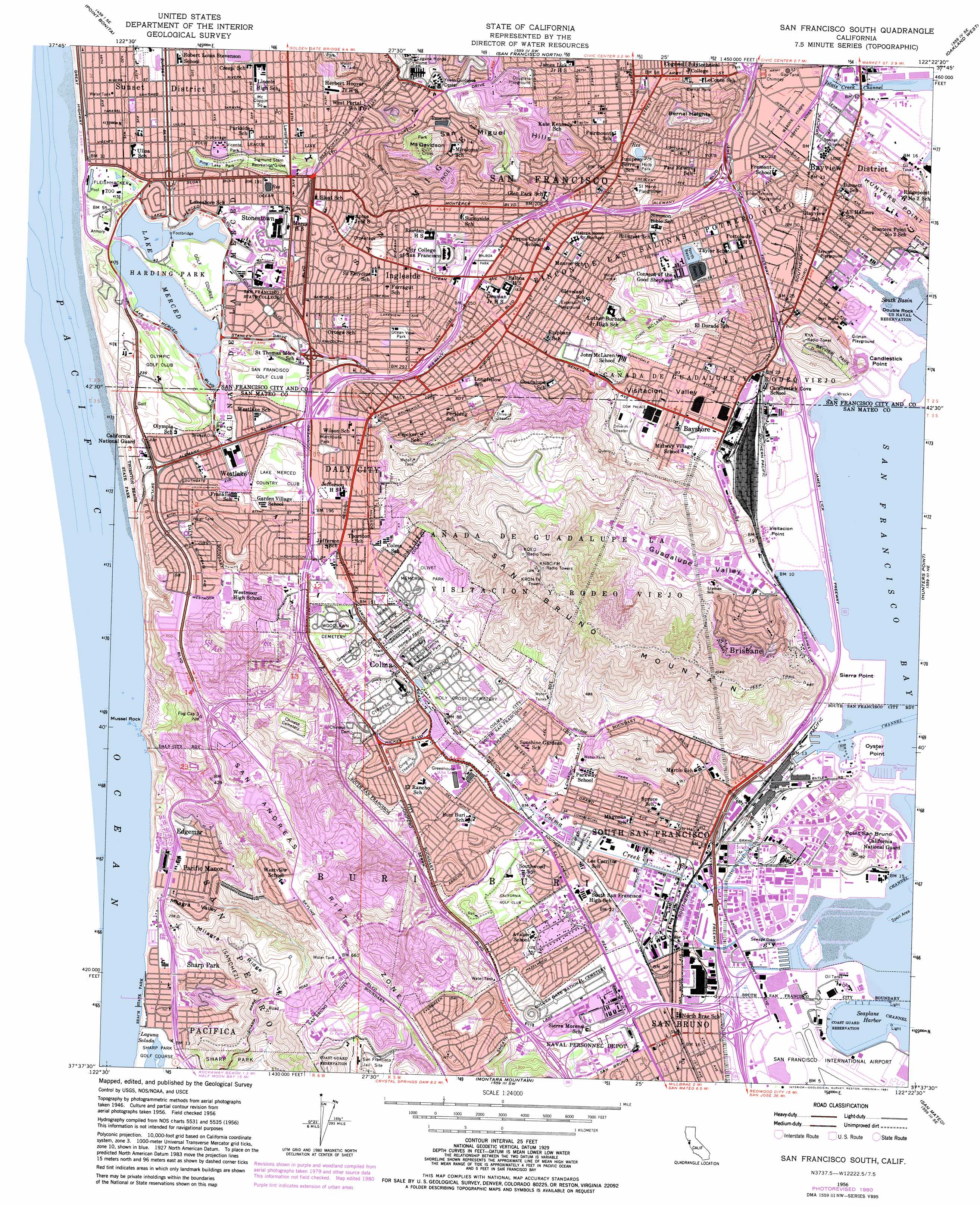
USGS Topo Quad 37122f4 - 1:24,000 scale
| Topo Map Name: | San Francisco South |
| USGS Topo Quad ID: | 37122f4 |
| Print Size: | ca. 21 1/4" wide x 27" high |
| Southeast Coordinates: | 37.625° N latitude / 122.375° W longitude |
| Map Center Coordinates: | 37.6875° N latitude / 122.4375° W longitude |
| U.S. State: | CA |
| Filename: | o37122f4.jpg |
| Download Map JPG Image: | San Francisco South topo map 1:24,000 scale |
| Map Type: | Topographic |
| Topo Series: | 7.5´ |
| Map Scale: | 1:24,000 |
| Source of Map Images: | United States Geological Survey (USGS) |
| Alternate Map Versions: |
San Francisco South CA 1947, updated 1955 Download PDF Buy paper map San Francisco South CA 1950 Download PDF Buy paper map San Francisco South CA 1956, updated 1958 Download PDF Buy paper map San Francisco South CA 1956, updated 1961 Download PDF Buy paper map San Francisco South CA 1956, updated 1967 Download PDF Buy paper map San Francisco South CA 1956, updated 1969 Download PDF Buy paper map San Francisco South CA 1956, updated 1975 Download PDF Buy paper map San Francisco South CA 1956, updated 1981 Download PDF Buy paper map San Francisco South CA 1993, updated 1997 Download PDF Buy paper map San Francisco South CA 1995, updated 1999 Download PDF Buy paper map San Francisco South CA 2012 Download PDF Buy paper map San Francisco South CA 2015 Download PDF Buy paper map |
1:24,000 Topo Quads surrounding San Francisco South
Bolinas |
San Rafael |
San Quentin |
Richmond |
Briones Valley |
Point Bonita |
San Francisco North |
Oakland West |
Oakland East |
|
San Francisco South |
Hunters Point |
San Leandro |
||
Montara Mountain |
San Mateo |
Redwood Point |
||
Half Moon Bay |
Woodside |
Palo Alto |
> Back to 37122e1 at 1:100,000 scale
> Back to 37122a1 at 1:250,000 scale
> Back to U.S. Topo Maps home
San Francisco South topo map: Gazetteer
San Francisco South: Airports
Police Pistol Range Heliport elevation 17m 55′San Francisco South: Bays
South Basin elevation 0m 0′San Francisco South: Beaches
Sharp Park Beach elevation 3m 9′San Francisco South: Canals
San Bruno Canal elevation 1m 3′San Francisco South: Capes
Candlestick Point elevation 29m 95′Oyster Point elevation 1m 3′
Sierra Point elevation 22m 72′
Visitacion Point elevation 7m 22′
San Francisco South: Channels
Islais Creek Channel elevation 0m 0′Oyster Point Channel elevation 0m 0′
San Francisco South: Crossings
Exit 423A elevation 4m 13′Exit 423B elevation 6m 19′
Exit 423C elevation 4m 13′
Exit 424 elevation 6m 19′
Exit 425A elevation 6m 19′
Exit 425B elevation 8m 26′
Exit 426A elevation 6m 19′
Exit 426B elevation 8m 26′
Exit 429A elevation 6m 19′
Exit 43A elevation 62m 203′
Exit 44 elevation 64m 209′
Exit 45 elevation 55m 180′
Exit 46 elevation 59m 193′
Exit 47A elevation 116m 380′
Exit 47B elevation 124m 406′
Exit 48 elevation 54m 177′
Exit 49A elevation 62m 203′
Exit 4B elevation 63m 206′
Exit 505B elevation 4m 13′
Exit 506 elevation 18m 59′
Exit 507 elevation 29m 95′
Exit 508 elevation 196m 643′
Exit 509A elevation 112m 367′
Exit 509B elevation 78m 255′
Exit 5A elevation 46m 150′
Exit 5B elevation 60m 196′
Exit 5C elevation 17m 55′
Exit 6A elevation 5m 16′
Exit 6B elevation 6m 19′
Exit 7 elevation 4m 13′
San Francisco South: Dams
Stanford Heights 10-013 Dam elevation 194m 636′Sunset South Basin 10-025 Dam elevation 117m 383′
University Mound North Basin 10-015 Dam elevation 56m 183′
University Mound South Basin 10-022 Dam elevation 56m 183′
San Francisco South: Harbors
East Basin elevation -1m -4′Seaplane Harbor elevation 0m 0′
West Basin elevation -1m -4′
San Francisco South: Islands
Double Rock elevation 0m 0′Mussel Rock elevation 1m 3′
San Francisco South: Lakes
Laguna Puerca elevation 10m 32′Laguna Salada elevation 4m 13′
Lake Merced elevation 7m 22′
McNab Lake elevation 67m 219′
San Francisco South: Parks
Adam Rogers Park elevation 35m 114′Aptos Playground elevation 98m 321′
Avalon Park elevation 24m 78′
Balboa Park elevation 61m 200′
Bayshore Circle Park elevation 9m 29′
Bayshore Heights Park elevation 44m 144′
Bayview Park elevation 106m 347′
Bayview Playground elevation 5m 16′
Beach State Park elevation 3m 9′
Bernal Heights Park elevation 111m 364′
Bernal Park elevation 21m 68′
Bernal Recreation Center elevation 64m 209′
Billy Goat Hill Park elevation 108m 354′
Briarwood Park elevation 35m 114′
Brooks Park elevation 144m 472′
Buri Buri Park elevation 18m 59′
Candlestick Point State Recreation Area elevation 2m 6′
Canterbury Tot Lot elevation 207m 679′
Cayuga Playground elevation 69m 226′
Chalmers Playground elevation 103m 337′
Commodore Park elevation 25m 82′
Coso Square elevation 30m 98′
Cox Stadium elevation 28m 91′
Crocker Amazon Playground elevation 75m 246′
Cypress and Pine Playlot elevation 9m 29′
Dorothy Erskine Park elevation 96m 314′
Douglas Playground elevation 179m 587′
Edgewood Park elevation 223m 731′
Elm Court Recreation Building elevation 39m 127′
Excelsior Playground elevation 71m 232′
F Hale Stephenson Field elevation 36m 118′
Fairmont Park elevation 190m 623′
Firth Memorial Park elevation 61m 200′
Fleetwood Park elevation 149m 488′
Forest Lane Park elevation 14m 45′
Frankfort Park elevation 133m 436′
Gellert Park elevation 97m 318′
George Christopher Playground elevation 142m 465′
Gilman Playground elevation 6m 19′
Glen Canyon Park elevation 108m 354′
Hampshire Tot Lot elevation 170m 557′
Harding Park elevation 16m 52′
Herman Park elevation 10m 32′
Herz Playground elevation 36m 118′
Hillside Park elevation 103m 337′
Hillside Recreation Center elevation 24m 78′
Hilltop Park elevation 71m 232′
Holly Park elevation 85m 278′
Imperial Park elevation 191m 626′
John McLaren Park elevation 115m 377′
Juri Commons elevation 30m 98′
Kelloch-Velasco Park elevation 15m 49′
Lake Merced Sports Center elevation 8m 26′
Larsen Park elevation 87m 285′
Lee Recreation Center elevation 22m 72′
Lincoln Playground elevation 106m 347′
Little Hollywood Park elevation 24m 78′
Longview Park elevation 118m 387′
Louis Sutter Playground elevation 55m 180′
Lysett Tot Lot elevation 179m 587′
Maloney Field elevation 13m 42′
Marchbank Park elevation 67m 219′
Merced Heights Playground elevation 86m 282′
Milagra Ridge County Park elevation 178m 583′
Milton Myer Recreation Center elevation 56m 183′
Miralona Playground elevation 205m 672′
Monster Park elevation 43m 141′
Monte Verde Park elevation 136m 446′
Mount Coppin Square elevation 108m 354′
Mount Davidson Park elevation 272m 892′
Mussel Rock City Park elevation 60m 196′
Northridge City Park elevation 144m 472′
Northwood Tot Lot elevation 60m 196′
Ocean View Park elevation 107m 351′
Ocean View Recreation Center elevation 115m 377′
Oyster Point Park elevation 8m 26′
Pacific Heights Park elevation 198m 649′
Palisades Park elevation 126m 413′
Paradise Valley Park elevation 60m 196′
Pine Lake Park elevation 11m 36′
Point San Bruno Park elevation 1m 3′
Pomo Park elevation 45m 147′
Portola Highlands Park elevation 200m 656′
Portola Recreation Center elevation 35m 114′
Rolph Playground elevation 10m 32′
Rolph-Nicol Playground elevation 49m 160′
Saint Marys Playground elevation 54m 177′
San Bruno Mountain State Park elevation 378m 1240′
Selick Park elevation 77m 252′
Seventh Avenue and Walnut Park elevation 4m 13′
Seventh Avenue Park elevation 8m 26′
Sigmund Stern Recreation Grove elevation 36m 118′
Sign Hill Park elevation 174m 570′
Silver Terrace Playground elevation 24m 78′
South Sunset Playground elevation 25m 82′
Southwood Playground elevation 27m 88′
Sunnyside Playground elevation 132m 433′
Sunset Heights Park elevation 222m 728′
Sweeny Ridge Reserve elevation 154m 505′
Thornton Beach State Park elevation 5m 16′
Upper Noe Recreation Center elevation 48m 157′
Vicente Park elevation 54m 177′
Visitacion Valley Playground elevation 23m 75′
Walter Haas Playground elevation 118m 387′
West Portal Playground elevation 121m 396′
West Sunset Playground elevation 35m 114′
Westborough Park elevation 133m 436′
Westlake Park elevation 13m 42′
Westmoor Park elevation 138m 452′
Winston Manor Park elevation 35m 114′
Youngblood-Coleman Playground elevation 13m 42′
Zamora Park elevation 47m 154′
San Francisco South: Populated Places
Andry Mobile Home Park elevation 59m 193′Baden elevation 28m 91′
Bayshore elevation 14m 45′
Bayview District elevation 22m 72′
Brisbane elevation 33m 108′
Broadmoor elevation 106m 347′
Broadmoor Village elevation 53m 173′
Colma elevation 37m 121′
Daly City elevation 124m 406′
Diamond Heights Village elevation 200m 656′
Edgemar elevation 39m 127′
Eldton elevation 91m 298′
Forest Hill elevation 184m 603′
Franciscan Mobile Home Park elevation 114m 374′
Glenridge elevation 153m 501′
Gold Mine Hill elevation 194m 636′
Ingleside elevation 92m 301′
Ingleside Heights elevation 85m 278′
Ingleside Terrace elevation 68m 223′
Meadowbrook Mobile Home Park elevation 46m 150′
Merced Heights elevation 111m 364′
Merced Manor elevation 64m 209′
Oceanview elevation 130m 426′
Pacific Manor elevation 31m 101′
Pacific Skies Mobile Home Park elevation 10m 32′
Park Merced elevation 40m 131′
Red Arrow Mobile Home Park elevation 20m 65′
Saint Francis Wood elevation 105m 344′
San Bruno elevation 5m 16′
Sharp Park elevation 28m 91′
Sherwood Forest elevation 219m 718′
Sholun elevation 102m 334′
Silver Terrace elevation 39m 127′
South San Francisco elevation 4m 13′
Stonestown elevation 45m 147′
Tanforan elevation 6m 19′
Treasure Island Mobile Home Park elevation 29m 95′
Village Square elevation 162m 531′
Vista Del Monte elevation 150m 492′
West Portal elevation 100m 328′
Westborough elevation 98m 321′
Westlake elevation 33m 108′
San Francisco South: Post Offices
Bayview Station San Francisco Post Office elevation 13m 42′Bernal Heights Station San Francisco Post Office elevation 31m 101′
Brisbane Post Office elevation 162m 531′
Chestnut Station South San Francisco Post Office elevation 10m 32′
Coloma Post Office elevation 27m 88′
Daly City Post Office elevation 64m 209′
Diamond Heights Station San Francisco Post Office elevation 164m 538′
Excelsior Station San Francisco Post Office elevation 51m 167′
Lakeshore Plaza Station San Francisco Post Office elevation 35m 114′
Linden Avenue Station South San Francisco Post Office elevation 10m 32′
McLaren Station San Francisco Post Office elevation 17m 55′
Pacifica Post Office elevation 27m 88′
Parkside Station San Francisco Post Office elevation 75m 246′
San Bruno Post Office elevation 4m 13′
South San Francisco Post Office elevation 4m 13′
Visitacion Station San Francisco Post Office elevation 19m 62′
Vista Grande Station Daly City Post Office elevation 106m 347′
West Portal Station San Francisco Post Office elevation 96m 314′
Westlake Station Daly City Post Office elevation 31m 101′
San Francisco South: Ranges
San Miguel Hills elevation 159m 521′San Francisco South: Reservoirs
North Basin elevation 58m 190′South Basin elevation 56m 183′
Twin Peaks Reservoir elevation 194m 636′
San Francisco South: Ridges
Milagra Ridge elevation 195m 639′San Francisco South: Streams
Colma Creek elevation 0m 0′San Bruno Creek elevation 57m 187′
San Francisco South: Summits
Bay View Hill elevation 128m 419′Bernal Heights elevation 132m 433′
Mount Davidson elevation 283m 928′
Point San Bruno elevation 45m 147′
San Bruno Mountain elevation 371m 1217′
Stony Hill elevation 86m 282′
Visitacion Knob elevation 158m 518′
San Francisco South: Tunnels
Twin Peaks Tunnel elevation 151m 495′San Francisco South: Valleys
Daisaku Ikeda Canyon elevation 3m 9′Guadalupe Valley elevation 6m 19′
Milagra Valley elevation 5m 16′
Visitacion Valley elevation 8m 26′
San Francisco South digital topo map on disk
Buy this San Francisco South topo map showing relief, roads, GPS coordinates and other geographical features, as a high-resolution digital map file on DVD: