Public Landing Topo Map Maryland
To zoom in, hover over the map of Public Landing
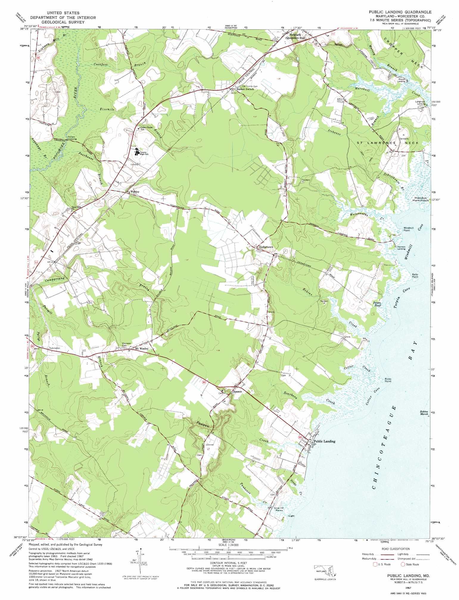
USGS Topo Quad 38075b3 - 1:24,000 scale
| Topo Map Name: | Public Landing |
| USGS Topo Quad ID: | 38075b3 |
| Print Size: | ca. 21 1/4" wide x 27" high |
| Southeast Coordinates: | 38.125° N latitude / 75.25° W longitude |
| Map Center Coordinates: | 38.1875° N latitude / 75.3125° W longitude |
| U.S. State: | MD |
| Filename: | o38075b3.jpg |
| Download Map JPG Image: | Public Landing topo map 1:24,000 scale |
| Map Type: | Topographic |
| Topo Series: | 7.5´ |
| Map Scale: | 1:24,000 |
| Source of Map Images: | United States Geological Survey (USGS) |
| Alternate Map Versions: |
Wesley MD 1942, updated 1962 Download PDF Buy paper map Public Landing MD 1967, updated 1968 Download PDF Buy paper map Public Landing MD 1967, updated 1969 Download PDF Buy paper map Public Landing MD 2011 Download PDF Buy paper map Public Landing MD 2014 Download PDF Buy paper map Public Landing MD 2016 Download PDF Buy paper map |
1:24,000 Topo Quads surrounding Public Landing
Delmar |
Pittsville |
Whaleysville |
Selbyville |
Assawoman Bay |
Salisbury |
Wango |
Ninepin Branch |
Berlin |
Ocean City |
Dividing Creek |
Snow Hill |
Public Landing |
Tingles Island |
|
Pocomoke City |
Girdletree |
Boxiron |
Whittington Point |
|
Hallwood |
Chincoteague West |
Chincoteague East |
> Back to 38075a1 at 1:100,000 scale
> Back to 38074a1 at 1:250,000 scale
> Back to U.S. Topo Maps home
Public Landing topo map: Gazetteer
Public Landing: Bays
Cotter Cove elevation 0m 0′Turpin Cove elevation 0m 0′
Windmill Cove elevation 0m 0′
Public Landing: Bridges
Porters Crossing elevation 1m 3′Public Landing: Capes
Cropper Neck elevation 3m 9′Kelly Point elevation 0m 0′
Ricks Point elevation 0m 0′
Saint Lawrence Neck elevation 3m 9′
Windmill Point elevation 0m 0′
Public Landing: Islands
Handys Hammock elevation 0m 0′Public Landing: Lakes
Peters Pond elevation 0m 0′Public Landing: Populated Places
Cedartown elevation 5m 16′Harmon Landing elevation 1m 3′
Harmon Landing Estates elevation 11m 36′
Langmaid Landing elevation 1m 3′
Mason Landing elevation 0m 0′
Mount Wesley elevation 11m 36′
Nathaniels Retreat elevation 12m 39′
Oak Hill Estates elevation 10m 32′
Public Landing elevation 3m 9′
Spence elevation 5m 16′
Wesley elevation 5m 16′
Public Landing: Streams
Acquango Branch elevation 1m 3′Coonfoot Branch elevation 2m 6′
Cotter Creek elevation 0m 0′
Fivemile Branch elevation 2m 6′
Icehouse Branch elevation 0m 0′
Massey Branch elevation 0m 0′
Pattys Branch elevation 1m 3′
Pawpaw Creek elevation 1m 3′
Poorhouse Branch elevation 2m 6′
Robins Creek elevation 2m 6′
Scarboro Creek elevation 0m 0′
Schoolhouse Branch elevation 0m 0′
Stagg Creek elevation 0m 0′
Tanhouse Creek elevation 1m 3′
Tilghman Mill Branch elevation 2m 6′
Waterworks Creek elevation 0m 0′
Public Landing digital topo map on disk
Buy this Public Landing topo map showing relief, roads, GPS coordinates and other geographical features, as a high-resolution digital map file on DVD:
Atlantic Coast (NY, NJ, PA, DE, MD, VA, NC)
Buy digital topo maps: Atlantic Coast (NY, NJ, PA, DE, MD, VA, NC)
 map DVD")