Ocean City Topo Map Maryland
To zoom in, hover over the map of Ocean City
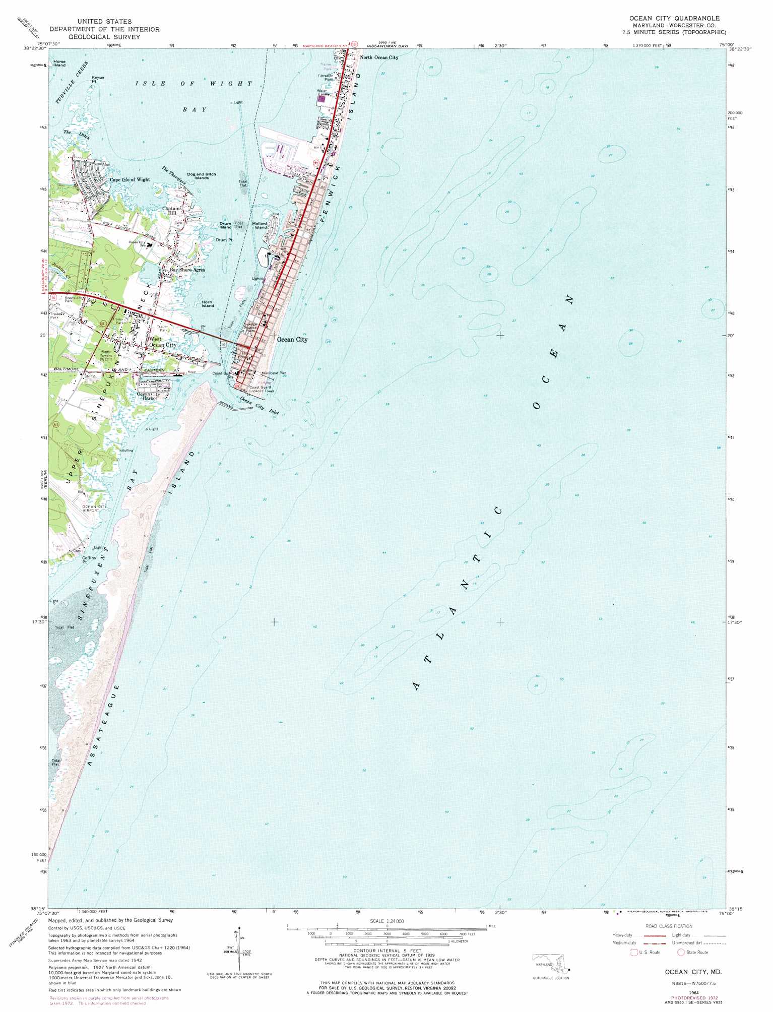
USGS Topo Quad 38075c1 - 1:24,000 scale
| Topo Map Name: | Ocean City |
| USGS Topo Quad ID: | 38075c1 |
| Print Size: | ca. 21 1/4" wide x 27" high |
| Southeast Coordinates: | 38.25° N latitude / 75° W longitude |
| Map Center Coordinates: | 38.3125° N latitude / 75.0625° W longitude |
| U.S. State: | MD |
| Filename: | o38075c1.jpg |
| Download Map JPG Image: | Ocean City topo map 1:24,000 scale |
| Map Type: | Topographic |
| Topo Series: | 7.5´ |
| Map Scale: | 1:24,000 |
| Source of Map Images: | United States Geological Survey (USGS) |
| Alternate Map Versions: |
Ocean City MD 1942, updated 1962 Download PDF Buy paper map Ocean City MD 1964, updated 1966 Download PDF Buy paper map Ocean City MD 1964, updated 1973 Download PDF Buy paper map Ocean City MD 1964, updated 1978 Download PDF Buy paper map Ocean City MD 1998, updated 2000 Download PDF Buy paper map Ocean City MD 2011 Download PDF Buy paper map Ocean City MD 2014 Download PDF Buy paper map Ocean City MD 2016 Download PDF Buy paper map |
1:24,000 Topo Quads surrounding Ocean City
Millsboro |
Frankford |
Bethany Beach |
||
Whaleysville |
Selbyville |
Assawoman Bay |
||
Ninepin Branch |
Berlin |
Ocean City |
||
Public Landing |
Tingles Island |
|||
Boxiron |
Whittington Point |
> Back to 38075a1 at 1:100,000 scale
> Back to 38074a1 at 1:250,000 scale
> Back to U.S. Topo Maps home
Ocean City topo map: Gazetteer
Ocean City: Airports
Hoopers Heliport elevation 2m 6′Ocean City Airport elevation 3m 9′
Ocean City Municipal Airport elevation 2m 6′
Ocean City: Bars
Great Gull Bank elevation 0m 0′Little Gull Bank elevation 0m 0′
Ocean City: Bays
Aleck Pond elevation 0m 0′Bluefish Cove elevation 0m 0′
Butterfish Cove elevation 0m 0′
Isle of Wight Bay elevation 0m 0′
Minnow Creek elevation 0m 0′
Ocean City Inlet elevation 0m 0′
Octopus Pond elevation 0m 0′
The Thorfare elevation 0m 0′
Trout Creek elevation 1m 3′
Wire Pond elevation 0m 0′
Ocean City: Bridges
Harry W Kelly Memorial Bridge elevation 0m 0′Ocean City: Capes
Coffins Point elevation 2m 6′Drum Point elevation 0m 0′
Keyser Point elevation 0m 0′
Upper Sinepuxent Neck elevation 3m 9′
Ocean City: Channels
The Ditch elevation 0m 0′Ocean City: Guts
Rosinbarrel Slough (historical) elevation 0m 0′Ocean City: Harbors
Ocean City Harbor elevation 0m 0′Swordfish Basin elevation 0m 0′
Ocean City: Islands
Collier Island elevation 0m 0′Collier Islands (historical) elevation 1m 3′
Dog and Bitch Islands elevation 0m 0′
Drum Island elevation 0m 0′
Grassy Island (historical) elevation 0m 0′
Horn Island elevation 0m 0′
Mallard Island elevation 2m 6′
Ocean City: Parks
Jolly Roger Amusement Park elevation 2m 6′Ocean City: Populated Places
Bay Shore Acres elevation 1m 3′Bayshore Estates elevation 2m 6′
Cape Isle of Wight elevation 1m 3′
Captains Hill elevation 2m 6′
Captains Knoll elevation 1m 3′
Eagles Nest Mobile Home Park elevation 2m 6′
Green Ridge Mobile Home Park elevation 2m 6′
Greenwood Place elevation 2m 6′
Harbor Mist Estates elevation 1m 3′
Herring Landing elevation 2m 6′
Mystic Harbor elevation 2m 6′
North Ocean City elevation 1m 3′
Ocean City elevation 1m 3′
Sea Isle Mobile Home Park elevation 3m 9′
West Ocean City elevation 1m 3′
Ocean City: Post Offices
Ocean City Post Office elevation 1m 3′West Ocean City Post Office (historical) elevation 1m 3′
Ocean City: Streams
Turville Creek elevation 0m 0′Ocean City digital topo map on disk
Buy this Ocean City topo map showing relief, roads, GPS coordinates and other geographical features, as a high-resolution digital map file on DVD:
Atlantic Coast (NY, NJ, PA, DE, MD, VA, NC)
Buy digital topo maps: Atlantic Coast (NY, NJ, PA, DE, MD, VA, NC)
 map DVD")