Nanticoke Topo Map Maryland
To zoom in, hover over the map of Nanticoke
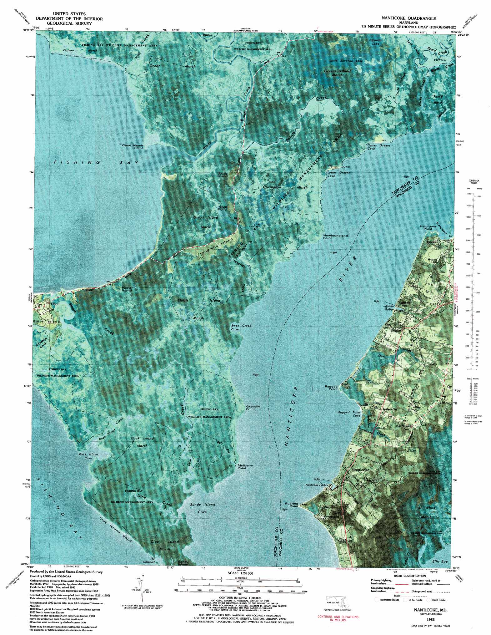
USGS Topo Quad 38075c8 - 1:24,000 scale
| Topo Map Name: | Nanticoke |
| USGS Topo Quad ID: | 38075c8 |
| Print Size: | ca. 21 1/4" wide x 27" high |
| Southeast Coordinates: | 38.25° N latitude / 75.875° W longitude |
| Map Center Coordinates: | 38.3125° N latitude / 75.9375° W longitude |
| U.S. State: | MD |
| Filename: | p38075c8.jpg |
| Download Map JPG Image: | Nanticoke topo map 1:24,000 scale |
| Map Type: | Orthophoto |
| Topo Series: | 7.5´ |
| Map Scale: | 1:24,000 |
| Source of Map Images: | United States Geological Survey (USGS) |
| Alternate Map Versions: |
Nanticoke MD 1942, updated 1962 Download PDF Buy paper map Nanticoke MD 1983, updated 1983 Download PDF Buy paper map Nanticoke MD 2011 Download PDF Buy paper map Nanticoke MD 2014 Download PDF Buy paper map Nanticoke MD 2016 Download PDF Buy paper map |
1:24,000 Topo Quads surrounding Nanticoke
Church Creek |
Cambridge |
East New Market |
Rhodesdale |
Sharptown |
Golden Hill |
Blackwater River |
Chicamacomico River |
Mardela Springs |
Hebron |
Honga |
Wingate |
Nanticoke |
Wetipquin |
Eden |
Richland Point |
Bloodsworth Island |
Deal Island |
Monie |
Princess Anne |
East Of Point Lookout |
Kedges Straits |
Terrapin Sand Point |
Marion |
Kingston |
> Back to 38075a1 at 1:100,000 scale
> Back to 38074a1 at 1:250,000 scale
> Back to U.S. Topo Maps home
Nanticoke topo map: Gazetteer
Nanticoke: Bays
Bivalve Harbor elevation 1m 3′Duck Island Cove elevation 0m 0′
Lower Greens Cove elevation 0m 0′
Ragged Point Cove elevation 0m 0′
Sandy Island Cove elevation 0m 0′
Swan Creek Cove elevation 0m 0′
The Tidepond elevation 1m 3′
Upper Greens Cove elevation 0m 0′
Nanticoke: Bends
Clay Island Bend elevation 0m 0′Nanticoke: Capes
Blue Point elevation 0m 0′Dasheills Point elevation 0m 0′
Gravelly Point elevation 0m 0′
Great Marsh Point elevation 1m 3′
Hatcrown Point elevation 1m 3′
Mulberry Point elevation 0m 0′
Newfoundland Point elevation 0m 0′
Ragged Point elevation 1m 3′
Roaring Point elevation 1m 3′
Nanticoke: Channels
Muddy Creek elevation 0m 0′Nanticoke: Harbors
Nanticoke Harbor elevation 0m 0′Nanticoke: Islands
Axies Island elevation 1m 3′Grays Island elevation 1m 3′
Greys Island elevation 1m 3′
Langrells Island elevation 1m 3′
Poplar Island elevation 1m 3′
Nanticoke: Parks
Cedar Hill Park elevation 5m 16′Fishing Bay Wildlife Management Area elevation 0m 0′
Nanticoke: Populated Places
Bivalve elevation 4m 13′Briar Patch elevation 3m 9′
Elliott elevation 3m 9′
Jesterville elevation 3m 9′
Nanticoke elevation 3m 9′
Nanticoke Acres elevation 1m 3′
Twin River Trailer Park elevation 2m 6′
Nanticoke: Post Offices
Bivalve Post Office elevation 5m 16′Nanticoke Post Office elevation 2m 6′
Nanticoke: Reservoirs
Little Savanna Lake elevation 0m 0′Nanticoke: Streams
Back Creek elevation 0m 0′Beard Creek elevation 0m 0′
Blue Point Branch elevation 1m 3′
Bozes Creek elevation 1m 3′
Broad Creek elevation 1m 3′
Bull Run elevation 1m 3′
Cedar Creek elevation 0m 0′
Cow Creek elevation 0m 0′
Duck Island Creek elevation 0m 0′
Dunn Creek elevation 1m 3′
Elliott Creek elevation 0m 0′
Irish Creek elevation 0m 0′
Island Creek elevation 0m 0′
Jacks Creek elevation 0m 0′
Langrells Creek elevation 0m 0′
Little Creek elevation 0m 0′
Little Creek elevation 1m 3′
Newfoundland Creek elevation 1m 3′
Newfoundland Point Creek elevation 0m 0′
Oystershell Creek elevation 1m 3′
Pokata Creek elevation 1m 3′
Steelyard Creek elevation 1m 3′
Wetipquin Creek elevation 0m 0′
Windsor Creek elevation 1m 3′
Nanticoke: Summits
Ryles Hill elevation 3m 9′Nanticoke: Swamps
Al White Marsh elevation 1m 3′Clay Island Marsh elevation 0m 0′
Covington Marsh elevation 0m 0′
Duck Island Marsh elevation 0m 0′
Elliott Island Marsh elevation 0m 0′
Grays Island Marsh elevation 1m 3′
Great Marsh elevation 1m 3′
Greens Island Marsh elevation 1m 3′
Nanticoke digital topo map on disk
Buy this Nanticoke topo map showing relief, roads, GPS coordinates and other geographical features, as a high-resolution digital map file on DVD:
Atlantic Coast (NY, NJ, PA, DE, MD, VA, NC)
Buy digital topo maps: Atlantic Coast (NY, NJ, PA, DE, MD, VA, NC)
 map DVD")