Assawoman Bay Topo Map Maryland
To zoom in, hover over the map of Assawoman Bay
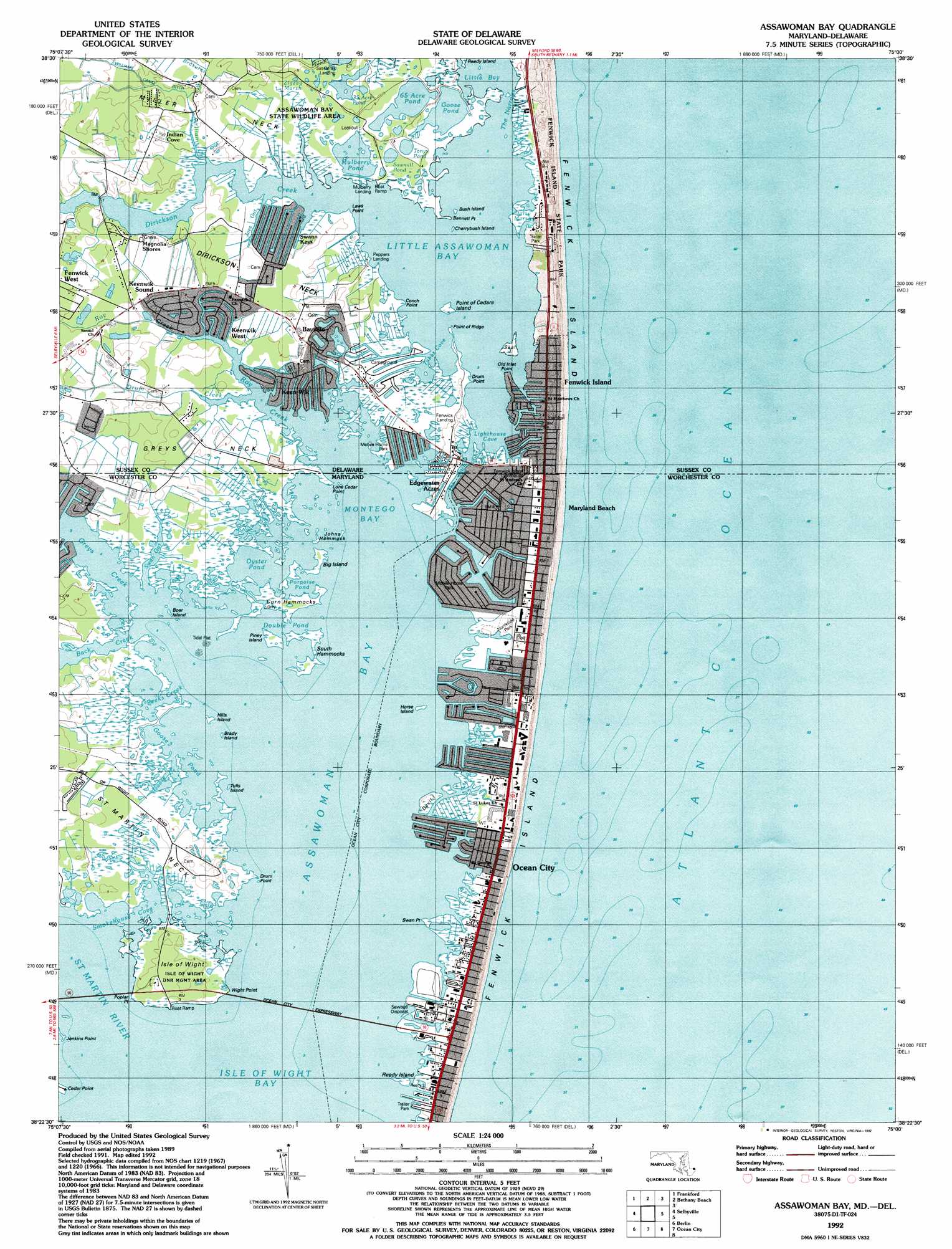
USGS Topo Quad 38075d1 - 1:24,000 scale
| Topo Map Name: | Assawoman Bay |
| USGS Topo Quad ID: | 38075d1 |
| Print Size: | ca. 21 1/4" wide x 27" high |
| Southeast Coordinates: | 38.375° N latitude / 75° W longitude |
| Map Center Coordinates: | 38.4375° N latitude / 75.0625° W longitude |
| U.S. States: | MD, DE |
| Filename: | o38075d1.jpg |
| Download Map JPG Image: | Assawoman Bay topo map 1:24,000 scale |
| Map Type: | Topographic |
| Topo Series: | 7.5´ |
| Map Scale: | 1:24,000 |
| Source of Map Images: | United States Geological Survey (USGS) |
| Alternate Map Versions: |
Assawoman Bay MD 1953 Download PDF Buy paper map Assawoman Bay MD 1967, updated 1969 Download PDF Buy paper map Assawoman Bay MD 1967, updated 1972 Download PDF Buy paper map Assawoman Bay MD 1967, updated 1982 Download PDF Buy paper map Assawoman Bay MD 1967, updated 1988 Download PDF Buy paper map Assawoman Bay MD 1992, updated 1992 Download PDF Buy paper map Assawoman Bay MD 1997, updated 2000 Download PDF Buy paper map Assawoman Bay MD 2013 Download PDF Buy paper map Assawoman Bay MD 2014 Download PDF Buy paper map Assawoman Bay MD 2016 Download PDF Buy paper map |
1:24,000 Topo Quads surrounding Assawoman Bay
Harbeson |
Fairmount |
Rehoboth Beach |
||
Millsboro |
Frankford |
Bethany Beach |
||
Whaleysville |
Selbyville |
Assawoman Bay |
||
Ninepin Branch |
Berlin |
Ocean City |
||
Public Landing |
Tingles Island |
> Back to 38075a1 at 1:100,000 scale
> Back to 38074a1 at 1:250,000 scale
> Back to U.S. Topo Maps home
Assawoman Bay topo map: Gazetteer
Assawoman Bay: Areas
Mattapany (historical) elevation 1m 3′Assawoman Bay: Bays
Assawoman Bay elevation 0m 0′Bayville Gut elevation 0m 0′
Goose Creek elevation 0m 0′
Lighthouse Cove elevation 0m 0′
Little Assawoman Bay elevation 0m 0′
Miller Creek elevation 0m 0′
Peeks Creek elevation 0m 0′
Smokehouse Cove elevation 0m 0′
Tubbs Cove elevation 0m 0′
Assawoman Bay: Beaches
Maryland Beach elevation 1m 3′Assawoman Bay: Bridges
Assawoman Bay Bridge elevation 0m 0′Assawoman Bay: Canals
The Ditch elevation 0m 0′Williams Canal Ditch elevation 2m 6′
Assawoman Bay: Capes
Bennett Point elevation 0m 0′Cedar Point elevation 0m 0′
Conch Point elevation 0m 0′
Dirickson Neck elevation 3m 9′
Drum Point elevation 0m 0′
Drum Point elevation 0m 0′
Greys Neck elevation 1m 3′
Jenkins Point elevation 0m 0′
Laws Point elevation 0m 0′
Lone Cedar Point elevation 1m 3′
Miller Neck elevation 1m 3′
Old Inlet Point elevation 0m 0′
Point of Cedars (historical) elevation 0m 0′
Point of Ridge elevation 0m 0′
Point of Ridge elevation 0m 0′
Poplar Point elevation 2m 6′
Saint Martin Neck elevation 1m 3′
Swan Point elevation 0m 0′
Wight Point elevation 0m 0′
Assawoman Bay: Channels
Marsh Narrows elevation 0m 0′The Ditch elevation 0m 0′
The Narrows elevation 0m 0′
Assawoman Bay: Guts
Joes Gut elevation 0m 0′Swan Gut elevation 0m 0′
Assawoman Bay: Islands
Big Island elevation 0m 0′Boar Island elevation 0m 0′
Brady Island elevation 0m 0′
Bush Island elevation 0m 0′
Cherrybush Island elevation 0m 0′
Corn Hammocks elevation 0m 0′
Devil Island elevation 0m 0′
Fenwick Island elevation 0m 0′
Hills Island elevation 0m 0′
Horse Island elevation 0m 0′
Isle of Wight elevation 1m 3′
Johns Hammock elevation 0m 0′
Marsh Island (historical) elevation 0m 0′
Oak Island (historical) elevation 0m 0′
Piney Island elevation 0m 0′
Point of Cedars Island elevation 0m 0′
Reedy Island elevation 0m 0′
Reedy Island (historical) elevation 2m 6′
Rich Island (historical) elevation 1m 3′
Seal Island elevation 0m 0′
South Hammocks elevation 0m 0′
Tulls Island elevation 0m 0′
Assawoman Bay: Lakes
Bounder Pond elevation 0m 0′Double Pond elevation 0m 0′
Goose Pond elevation 0m 0′
Goose Pond elevation 0m 0′
Mulberry Pond elevation 0m 0′
Oyster Pond elevation 0m 0′
Porpoise Pond elevation 0m 0′
Rodney Pond elevation 0m 0′
Sawmill Pond elevation 1m 3′
Sixty Five Acre Pond elevation 0m 0′
Thirty-five Acre Pond elevation 1m 3′
Tonys Pond elevation 1m 3′
Assawoman Bay: Parks
Assawoman Bay State Wildlife Area elevation 1m 3′Fenwick Island State Park elevation 4m 13′
Gorman Avenue Park elevation 1m 3′
Isle of Wight Department of Natural Resources Management Area elevation 1m 3′
Isle of Wight Natural Resources Management Area elevation 2m 6′
Northside Park elevation 1m 3′
Sixtyfirst Street Park elevation 2m 6′
Assawoman Bay: Populated Places
Bayside Keys elevation 2m 6′Bayville elevation 3m 9′
Caine Harbor Mile elevation 0m 0′
Caine Keys elevation 1m 3′
Cainwoods elevation 1m 3′
Cape Windsor Mobile Home Park elevation 0m 0′
Edgewater Acres elevation 1m 3′
Fenwick elevation 2m 6′
Fenwick Estates elevation 3m 9′
Fenwick Island elevation 3m 9′
Fenwick Landing elevation 1m 3′
Fenwick West elevation 3m 9′
Hidden Harbor elevation 1m 3′
Indian Cove elevation 1m 3′
Keen-Wik elevation 0m 0′
Keenwik Sound elevation 1m 3′
Keenwik West elevation 0m 0′
Kings Grant elevation 2m 6′
Magnolia Shores elevation 1m 3′
Montego Bay elevation 1m 3′
Montego Bay Mobile Home Park elevation 1m 3′
Mulberry Landing elevation 0m 0′
Oak Acres elevation 3m 9′
Ocean Bay City elevation 1m 3′
Peppers Landing elevation 0m 0′
Queens Quest elevation 1m 3′
Sassafras Landing elevation 0m 0′
Sea Dunes elevation 1m 3′
Seaside Villas elevation 2m 6′
Seatowne elevation 1m 3′
Shady Park Mobile Home Park elevation 2m 6′
Swann Keys elevation 1m 3′
Teaberry Woods elevation 1m 3′
The Narrows elevation 0m 0′
The Shoals elevation 2m 6′
Warrens Park elevation 1m 3′
Assawoman Bay: Post Offices
Montego Station Ocean City Post Office elevation 2m 6′North Ocean City Station Ocean City Post Office elevation 2m 6′
Assawoman Bay: Streams
Back Creek elevation 0m 0′Brasures Branch elevation 1m 3′
Dirickson Creek elevation 0m 0′
Drum Creek elevation 0m 0′
Greys Creek elevation 0m 0′
Roy Creek elevation 0m 0′
Saint Martin River elevation 0m 0′
Williams Creek elevation 0m 0′
Assawoman Bay: Swamps
Daisy Marsh elevation 0m 0′Zigzag Marsh elevation 1m 3′
Assawoman Bay digital topo map on disk
Buy this Assawoman Bay topo map showing relief, roads, GPS coordinates and other geographical features, as a high-resolution digital map file on DVD:
Atlantic Coast (NY, NJ, PA, DE, MD, VA, NC)
Buy digital topo maps: Atlantic Coast (NY, NJ, PA, DE, MD, VA, NC)
 map DVD")