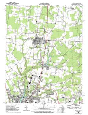
Delmar Topo Map Maryland
To zoom in, hover over the map of Delmar
USGS Topo Quad 38075d5 - 1:24,000 scale
| Topo Map Name: | Delmar |
| USGS Topo Quad ID: | 38075d5 |
| Print Size: | ca. 21 1/4" wide x 27" high |
| Southeast Coordinates: | 38.375° N latitude / 75.5° W longitude |
| Map Center Coordinates: | 38.4375° N latitude / 75.5625° W longitude |
| U.S. States: | MD, DE |
| Filename: | o38075d5.jpg |
| Download Map JPG Image: | Delmar topo map 1:24,000 scale |
| Map Type: | Topographic |
| Topo Series: | 7.5´ |
| Map Scale: | 1:24,000 |
| Source of Map Images: | United States Geological Survey (USGS) |
| Alternate Map Versions: |
Delmar MD 1942, updated 1983 Download PDF Buy paper map Delmar MD 1953, updated 1953 Download PDF Buy paper map Delmar MD 1971 Download PDF Buy paper map Delmar MD 1992, updated 1992 Download PDF Buy paper map Delmar MD 2011 Download PDF Buy paper map Delmar MD 2014 Download PDF Buy paper map Delmar MD 2016 Download PDF Buy paper map |
1:24,000 Topo Quads surrounding Delmar
> Back to 38075a1 at 1:100,000 scale
> Back to 38074a1 at 1:250,000 scale
> Back to U.S. Topo Maps home
Delmar topo map: Gazetteer
Delmar: Airports
Bennett Airport elevation 15m 49′Delmar State Line Airport elevation 14m 45′
Ennis Aerodrome elevation 13m 42′
Salisbury Airport (historical) elevation 13m 42′
Delmar: Dams
Johnson Dam elevation 1m 3′Leonard Pond Dam elevation 8m 26′
Delmar: Lakes
Burnt Pond elevation 6m 19′Johnson Pond elevation 3m 9′
Leonard Pond elevation 10m 32′
Nailers Pond elevation 4m 13′
Williams Pond elevation 10m 32′
Delmar: Parks
Gordy Park elevation 15m 49′Green Acres Memorial Park elevation 12m 39′
Indian Village Neighborhood Park elevation 11m 36′
Lake Street Park elevation 7m 22′
Leonards Mill Park elevation 8m 26′
Leonards Mill Park elevation 11m 36′
Naylor Mill Park elevation 13m 42′
North Lake Park elevation 7m 22′
Delmar: Populated Places
Avalon Park elevation 14m 45′Beaver Run Manor elevation 13m 42′
Bennett Park elevation 12m 39′
Bremerton elevation 18m 59′
Brookdale Heights elevation 12m 39′
Cannon Farm elevation 13m 42′
Carey Acres elevation 15m 49′
Chesapeake Heights elevation 14m 45′
Chestnut Hill elevation 13m 42′
Cloverdale Farm elevation 11m 36′
Colonial Acres elevation 14m 45′
Country Comforts elevation 17m 55′
Danwood elevation 14m 45′
Deerfield elevation 13m 42′
Deers Head Manor elevation 9m 29′
Delmar elevation 16m 52′
Delmar elevation 17m 55′
Ellegood Estates elevation 13m 42′
Essex Ridge elevation 19m 62′
Foxwood elevation 15m 49′
Gateway Mobile Home Park elevation 13m 42′
Green Acres elevation 12m 39′
Green Meadows Mobile Home Park elevation 13m 42′
Greenlawn elevation 14m 45′
Greenwood Manor elevation 14m 45′
Grenada Manor elevation 16m 52′
Hayden Acres elevation 16m 52′
Hideaway Acres elevation 18m 59′
Holland Heights elevation 11m 36′
Holly Oak Mobile Home Park elevation 16m 52′
Hollylake Estates elevation 13m 42′
Hudson Heights elevation 11m 36′
Hyde Park elevation 8m 26′
Jersey Heights elevation 12m 39′
Jersey Road Estates elevation 13m 42′
Justice Heights elevation 13m 42′
Kathleens Delight elevation 11m 36′
Kenilworth elevation 15m 49′
Kirkwood elevation 12m 39′
Lakeside Manor elevation 7m 22′
Leonard Farm elevation 11m 36′
Little Acres elevation 12m 39′
Manokin elevation 11m 36′
Maple Plains elevation 11m 36′
Maria Acres elevation 17m 55′
Middle Neck elevation 14m 45′
Moss Hill Acres elevation 11m 36′
Mount Vernon elevation 10m 32′
Naylor Mill Village Trailer Park elevation 13m 42′
Northwood elevation 11m 36′
Nottingham Woods elevation 13m 42′
Oak Haven elevation 13m 42′
Oakdale Acres elevation 13m 42′
Overbrook Manor elevation 10m 32′
Parker Heights elevation 12m 39′
Parkhurst Manor elevation 13m 42′
Pembroke Hills elevation 18m 59′
Pine Grove elevation 13m 42′
Pine Knoll Terrace elevation 14m 45′
Plainfield elevation 15m 49′
Pleasant Acres elevation 13m 42′
Poets Colony elevation 9m 29′
Rosewood Forest elevation 18m 59′
Rum Ridge Estates elevation 14m 45′
Saint George elevation 13m 42′
Salisbury Mobile Home Community elevation 13m 42′
Santa Fe Acres elevation 12m 39′
Sherwood Manor elevation 14m 45′
Sierra Manor elevation 16m 52′
Smith Hill elevation 12m 39′
Smithwood Manor elevation 15m 49′
Spring Hill Acres elevation 11m 36′
Stage Mobile Home Village elevation 15m 49′
Stellas Venture elevation 17m 55′
Sunset Heights elevation 8m 26′
Victory Gardens elevation 14m 45′
Walston elevation 16m 52′
Walston Switch elevation 16m 52′
Wellington Estates elevation 11m 36′
Westerlee elevation 14m 45′
Westlake elevation 5m 16′
Westover Hills elevation 9m 29′
Westside Mobile Home Park elevation 14m 45′
Westview elevation 12m 39′
Westwood elevation 7m 22′
Whittington Park elevation 14m 45′
Wilcher Park elevation 15m 49′
Woodlawn elevation 15m 49′
Delmar: Reservoirs
Johnsons Pond elevation 1m 3′Leonard Pond elevation 8m 26′
Delmar: Streams
Andrews Branch elevation 10m 32′Brewington Branch elevation 4m 13′
Connelly Mill Branch elevation 5m 16′
Halloway Branch elevation 12m 39′
Jackson Branch elevation 10m 32′
Leonard Pond Run elevation 4m 13′
Little Burnt Branch elevation 11m 36′
Mayer Branch elevation 12m 39′
Middle Neck Branch elevation 6m 19′
Morris Branch elevation 12m 39′
Morris Branch elevation 12m 39′
North Prong Leonard Pond Run elevation 10m 32′
Peggy Branch elevation 4m 13′
South Prong Leonard Pond Run elevation 10m 32′
Tilghman Branch elevation 14m 45′
Vena Gains Branch elevation 12m 39′
Wheeling Branch elevation 13m 42′
Wood Creek elevation 7m 22′
Delmar digital topo map on disk
Buy this Delmar topo map showing relief, roads, GPS coordinates and other geographical features, as a high-resolution digital map file on DVD:
Atlantic Coast (NY, NJ, PA, DE, MD, VA, NC)
Buy digital topo maps: Atlantic Coast (NY, NJ, PA, DE, MD, VA, NC)


