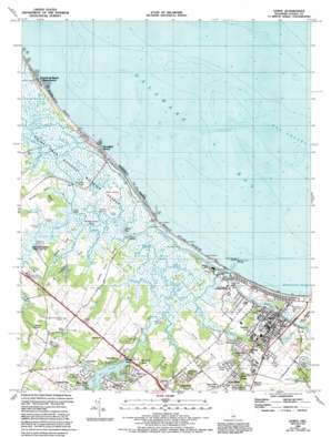
Lewes Topo Map Delaware
To zoom in, hover over the map of Lewes
USGS Topo Quad 38075g2 - 1:24,000 scale
| Topo Map Name: | Lewes |
| USGS Topo Quad ID: | 38075g2 |
| Print Size: | ca. 21 1/4" wide x 27" high |
| Southeast Coordinates: | 38.75° N latitude / 75.125° W longitude |
| Map Center Coordinates: | 38.8125° N latitude / 75.1875° W longitude |
| U.S. State: | DE |
| Filename: | o38075g2.jpg |
| Download Map JPG Image: | Lewes topo map 1:24,000 scale |
| Map Type: | Topographic |
| Topo Series: | 7.5´ |
| Map Scale: | 1:24,000 |
| Source of Map Images: | United States Geological Survey (USGS) |
| Alternate Map Versions: |
Lewes DE 1944 Download PDF Buy paper map Lewes DE 1944 Download PDF Buy paper map Lewes DE 1954, updated 1956 Download PDF Buy paper map Lewes DE 1954, updated 1968 Download PDF Buy paper map Lewes DE 1954, updated 1972 Download PDF Buy paper map Lewes DE 1954, updated 1984 Download PDF Buy paper map Lewes DE 1984, updated 1984 Download PDF Buy paper map Lewes DE 1984, updated 1985 Download PDF Buy paper map Lewes DE 1984, updated 1992 Download PDF Buy paper map Lewes DE 1997, updated 2000 Download PDF Buy paper map Lewes DE 2011 Download PDF Buy paper map Lewes DE 2014 Download PDF Buy paper map Lewes DE 2016 Download PDF Buy paper map |
1:24,000 Topo Quads surrounding Lewes
Frederica |
Bennetts Pier |
Rio Grande |
||
Milford |
Mispillion River |
Cape May |
||
Ellendale |
Milton |
Lewes |
Cape Henlopen |
|
Georgetown |
Harbeson |
Fairmount |
Rehoboth Beach |
|
Trap Pond |
Millsboro |
Frankford |
Bethany Beach |
> Back to 38075e1 at 1:100,000 scale
> Back to 38074a1 at 1:250,000 scale
> Back to U.S. Topo Maps home
Lewes topo map: Gazetteer
Lewes: Airports
Eagle Crest-Hudson Airport elevation 7m 22′Lewes: Bars
The Shears elevation 0m 0′The Shears elevation 0m 0′
Whale Back elevation 0m 0′
Lewes: Bays
Broadkill Sound elevation 1m 3′Lewes: Beaches
Broadkill Beach elevation 0m 0′Old Inlet Beach elevation 3m 9′
Primehook Beach elevation 0m 0′
Lewes: Bridges
South Street Bridge elevation 1m 3′Lewes: Canals
Petersfield Ditch elevation 1m 3′Lewes: Capes
Covington Neck elevation 1m 3′Hells Neck elevation 4m 13′
Oyster Rocks Neck elevation 1m 3′
Plumb Point (historical) elevation 0m 0′
White Neck elevation 2m 6′
Lewes: Channels
Flatland Reach elevation 1m 3′Long Reach elevation 1m 3′
No Mans Friend Reach elevation 1m 3′
Lewes: Dams
Red Mill Pond Dam elevation 2m 6′Lewes: Guts
Black Hog Gut elevation 1m 3′Roosevelt Inlet elevation 0m 0′
Lewes: Islands
Beach Plum Island elevation 0m 0′Petersfield Island elevation 1m 3′
Wall Island elevation 1m 3′
Lewes: Lakes
Blockhouse Pond elevation 1m 3′Bookhammers Pond elevation 3m 9′
Holland Pond elevation 1m 3′
Shell Beach Pond elevation 0m 0′
Lewes: Parks
Beach Plum Island State Park elevation 0m 0′Lewes: Populated Places
Black Hog Landing elevation 1m 3′Broadkill Beach elevation 3m 9′
Capes Cove Mobile Home Park elevation 6m 19′
Carsylian Acres elevation 6m 19′
Covey Creek elevation 7m 22′
Cripple Creek elevation 6m 19′
Donovan Development elevation 6m 19′
Dutch Acres elevation 6m 19′
East Mill Run elevation 7m 22′
Edgewater elevation 7m 22′
Green Hill elevation 2m 6′
Hazzard Landing elevation 1m 3′
Heronwood elevation 4m 13′
Highland Acres elevation 4m 13′
Highland Acres elevation 3m 9′
Houston elevation 3m 9′
Lewes elevation 4m 13′
Lewes Beach elevation 4m 13′
McNichol Place elevation 7m 22′
Mill Creek Manor elevation 7m 22′
Mill Pond Acres elevation 7m 22′
Millpond Acres elevation 6m 19′
Murrays Corner elevation 7m 22′
Nassau elevation 8m 26′
Overbrook elevation 8m 26′
Overbrook Shores elevation 6m 19′
Oyster Rocks elevation 1m 3′
Pilottown elevation 4m 13′
Primehook Beach elevation 1m 3′
Quakers Heights elevation 7m 22′
Quakertown elevation 7m 22′
Red Hill Manor elevation 6m 19′
Robertson Landing elevation 1m 3′
Sand Dunes Village elevation 6m 19′
Savannah Place elevation 4m 13′
Shady Side elevation 9m 29′
Shaffer Property elevation 7m 22′
Star Landing elevation 1m 3′
Steamboat Landing elevation 3m 9′
Swanendael elevation 3m 9′
Sweet Briar Mobile Home Park elevation 6m 19′
Wescoats Corner elevation 9m 29′
Wiltbank Landing elevation 2m 6′
Lewes: Post Offices
Lewes Post Office elevation 4m 13′Lewes: Reservoirs
Red Mill Pond elevation 2m 6′Lewes: Streams
Broadkill River elevation 1m 3′Canary Creek elevation 1m 3′
Crooked Creek elevation 1m 3′
Ditch Creek elevation 1m 3′
Doty Glade elevation 1m 3′
Ebenezer Branch elevation 1m 3′
Fisher Creek elevation 1m 3′
Old Mill Creek elevation 1m 3′
Primehook Creek elevation 2m 6′
Lewes: Swamps
Davidson Marsh elevation 1m 3′Great Marsh elevation 1m 3′
Roach Marsh elevation 1m 3′
Lewes digital topo map on disk
Buy this Lewes topo map showing relief, roads, GPS coordinates and other geographical features, as a high-resolution digital map file on DVD:
Atlantic Coast (NY, NJ, PA, DE, MD, VA, NC)
Buy digital topo maps: Atlantic Coast (NY, NJ, PA, DE, MD, VA, NC)


