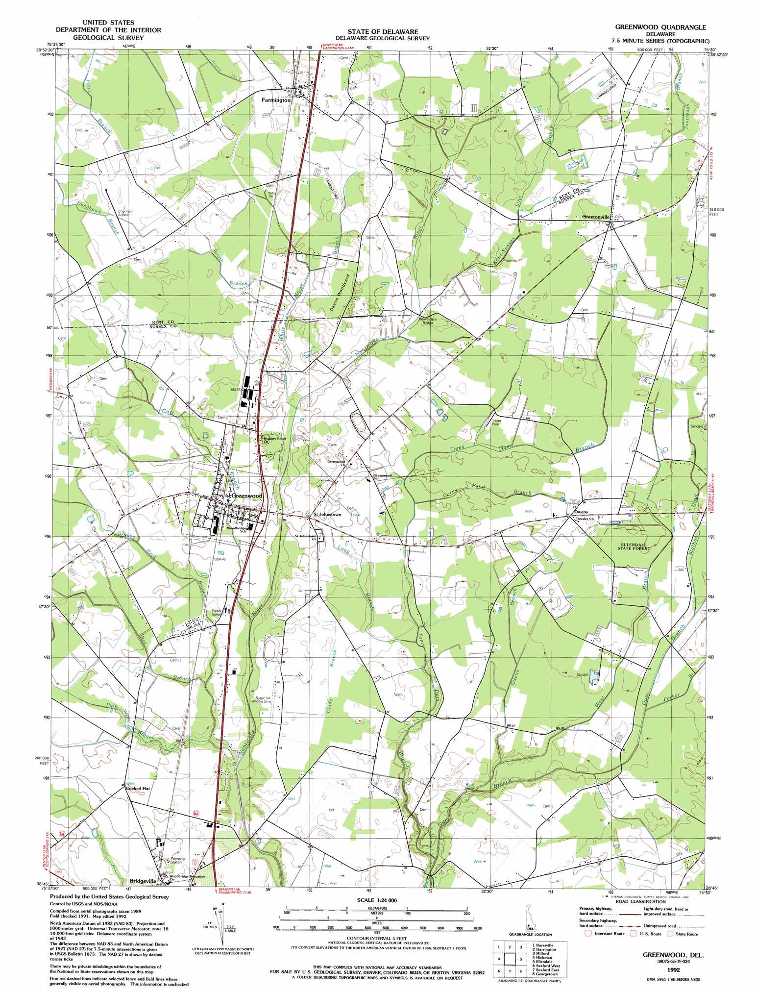
Greenwood Topo Map Delaware
To zoom in, hover over the map of Greenwood
USGS Topo Quad 38075g5 - 1:24,000 scale
| Topo Map Name: | Greenwood |
| USGS Topo Quad ID: | 38075g5 |
| Print Size: | ca. 21 1/4" wide x 27" high |
| Southeast Coordinates: | 38.75° N latitude / 75.5° W longitude |
| Map Center Coordinates: | 38.8125° N latitude / 75.5625° W longitude |
| U.S. State: | DE |
| Filename: | o38075g5.jpg |
| Download Map JPG Image: | Greenwood topo map 1:24,000 scale |
| Map Type: | Topographic |
| Topo Series: | 7.5´ |
| Map Scale: | 1:24,000 |
| Source of Map Images: | United States Geological Survey (USGS) |
| Alternate Map Versions: |
Greenwood DE 1955, updated 1957 Download PDF Buy paper map Greenwood DE 1955, updated 1982 Download PDF Buy paper map Greenwood DE 1992, updated 1992 Download PDF Buy paper map Greenwood DE 2011 Download PDF Buy paper map Greenwood DE 2014 Download PDF Buy paper map Greenwood DE 2016 Download PDF Buy paper map |
1:24,000 Topo Quads surrounding Greenwood
Goldsboro |
Marydel |
Wyoming |
Frederica |
Bennetts Pier |
Denton |
Burrsville |
Harrington |
Milford |
Mispillion River |
Hobbs |
Hickman |
Greenwood |
Ellendale |
Milton |
Federalsburg |
Seaford West |
Seaford East |
Georgetown |
Harbeson |
Rhodesdale |
Sharptown |
Laurel |
Trap Pond |
Millsboro |
> Back to 38075e1 at 1:100,000 scale
> Back to 38074a1 at 1:250,000 scale
> Back to U.S. Topo Maps home
Greenwood topo map: Gazetteer
Greenwood: Airports
Sugar Hill Airport elevation 12m 39′Greenwood: Bays
Rye Hole elevation 8m 26′Greenwood: Bridges
Beaverdam Bridge elevation 15m 49′Greenwood: Forests
Ellendale State Forest elevation 14m 45′Greenwood: Populated Places
Bridgeville North elevation 14m 45′Cocked Hat elevation 15m 49′
Deer Creek elevation 14m 45′
Farmington elevation 18m 59′
Greenwood elevation 14m 45′
Greenwood Gardens elevation 14m 45′
Hickory Ridge elevation 16m 52′
Newton Woods elevation 12m 39′
Owens elevation 16m 52′
Saint Johnstown elevation 15m 49′
Staytonville elevation 26m 85′
Greenwood: Post Offices
Greenwood Post Office elevation 13m 42′Greenwood: Streams
Bee Branch elevation 9m 29′Booth Branch elevation 15m 49′
Cart Branch elevation 12m 39′
Crony Pond Branch elevation 14m 45′
Glade Branch elevation 11m 36′
Grubby Neck Branch elevation 11m 36′
Kent-Sussex Line Branch elevation 15m 49′
Long Branch elevation 12m 39′
Owens Branch elevation 9m 29′
Parker Branch elevation 12m 39′
Polk Branch elevation 8m 26′
Stallion Head Branch elevation 16m 52′
Toms Dam Branch elevation 8m 26′
West Branch Gum Branch elevation 9m 29′
White Marsh Branch elevation 13m 42′
Greenwood: Swamps
Sharps Pond elevation 10m 32′Greenwood: Woods
Devils Woodyard elevation 16m 52′Greenwood digital topo map on disk
Buy this Greenwood topo map showing relief, roads, GPS coordinates and other geographical features, as a high-resolution digital map file on DVD:
Atlantic Coast (NY, NJ, PA, DE, MD, VA, NC)
Buy digital topo maps: Atlantic Coast (NY, NJ, PA, DE, MD, VA, NC)
 map DVD")