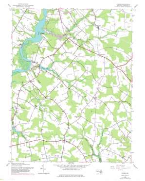
Hobbs Topo Map Maryland
To zoom in, hover over the map of Hobbs
USGS Topo Quad 38075g7 - 1:24,000 scale
| Topo Map Name: | Hobbs |
| USGS Topo Quad ID: | 38075g7 |
| Print Size: | ca. 21 1/4" wide x 27" high |
| Southeast Coordinates: | 38.75° N latitude / 75.75° W longitude |
| Map Center Coordinates: | 38.8125° N latitude / 75.8125° W longitude |
| U.S. State: | MD |
| Filename: | o38075g7.jpg |
| Download Map JPG Image: | Hobbs topo map 1:24,000 scale |
| Map Type: | Topographic |
| Topo Series: | 7.5´ |
| Map Scale: | 1:24,000 |
| Source of Map Images: | United States Geological Survey (USGS) |
| Alternate Map Versions: |
Hobbs MD 1944, updated 1962 Download PDF Buy paper map Hobbs MD 1944, updated 1976 Download PDF Buy paper map Hobbs MD 2011 Download PDF Buy paper map Hobbs MD 2014 Download PDF Buy paper map Hobbs MD 2017 Download PDF Buy paper map |
1:24,000 Topo Quads surrounding Hobbs
> Back to 38075e1 at 1:100,000 scale
> Back to 38074a1 at 1:250,000 scale
> Back to U.S. Topo Maps home
Hobbs topo map: Gazetteer
Hobbs: Airports
Houghton Airport elevation 13m 42′Slater Field elevation 12m 39′
Hobbs: Dams
Nagels Mill Pond Dam elevation 6m 19′Smithville Lake Dam elevation 13m 42′
Williston Mill Dam elevation 8m 26′
Hobbs: Lakes
Williston Lake elevation 8m 26′Hobbs: Parks
Caroline County 4-H Club and Youth Park elevation 14m 45′Martinak State Park elevation 6m 19′
Hobbs: Populated Places
Agner elevation 13m 42′American Corner elevation 15m 49′
Andersontown elevation 16m 52′
Asbury elevation 7m 22′
Bureau elevation 12m 39′
Concord elevation 17m 55′
Country Club Estates elevation 11m 36′
Double Hills Estates elevation 7m 22′
Fairways elevation 11m 36′
Hobbs elevation 15m 49′
Legion Heights elevation 14m 45′
Lyford Landing elevation 9m 29′
Pealiquor Landing elevation 7m 22′
Potters Landing elevation 2m 6′
Stafford Heights elevation 8m 26′
Two Johns Estates elevation 8m 26′
Williams Heights elevation 6m 19′
Williston elevation 7m 22′
Hobbs: Reservoirs
Lake Pinehurst elevation 6m 19′Smithville Community Lake elevation 13m 42′
Hobbs: Streams
Gravelly Branch elevation 0m 0′Herring Run elevation 0m 0′
Long Branch elevation 0m 0′
Mill Creek elevation 2m 6′
Poor House Run elevation 1m 3′
Raccoon Branch elevation 10m 32′
Watts Creek elevation 0m 0′
Wolfpit Branch elevation 9m 29′
Hobbs: Summits
Opossum Hill elevation 18m 59′Hobbs digital topo map on disk
Buy this Hobbs topo map showing relief, roads, GPS coordinates and other geographical features, as a high-resolution digital map file on DVD:
Atlantic Coast (NY, NJ, PA, DE, MD, VA, NC)
Buy digital topo maps: Atlantic Coast (NY, NJ, PA, DE, MD, VA, NC)


