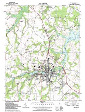
Milford Topo Map Delaware
To zoom in, hover over the map of Milford
USGS Topo Quad 38075h4 - 1:24,000 scale
| Topo Map Name: | Milford |
| USGS Topo Quad ID: | 38075h4 |
| Print Size: | ca. 21 1/4" wide x 27" high |
| Southeast Coordinates: | 38.875° N latitude / 75.375° W longitude |
| Map Center Coordinates: | 38.9375° N latitude / 75.4375° W longitude |
| U.S. State: | DE |
| Filename: | o38075h4.jpg |
| Download Map JPG Image: | Milford topo map 1:24,000 scale |
| Map Type: | Topographic |
| Topo Series: | 7.5´ |
| Map Scale: | 1:24,000 |
| Source of Map Images: | United States Geological Survey (USGS) |
| Alternate Map Versions: |
Milford DE 1954, updated 1955 Download PDF Buy paper map Milford DE 1954, updated 1969 Download PDF Buy paper map Milford DE 1954, updated 1982 Download PDF Buy paper map Milford DE 1993, updated 1993 Download PDF Buy paper map Milford DE 2011 Download PDF Buy paper map Milford DE 2014 Download PDF Buy paper map Milford DE 2016 Download PDF Buy paper map |
1:24,000 Topo Quads surrounding Milford
> Back to 38075e1 at 1:100,000 scale
> Back to 38074a1 at 1:250,000 scale
> Back to U.S. Topo Maps home
Milford topo map: Gazetteer
Milford: Airports
Drummond Airport elevation 9m 29′Kimbowrosa Farm Airport elevation 9m 29′
Milford Airpark (historical) elevation 11m 36′
Milford: Bridges
Carpenters Bridge elevation 2m 6′Fork Landing Bridge elevation 2m 6′
Milford: Dams
Abbotts Pond Dam elevation 10m 32′Blairs Pond Dam elevation 9m 29′
Griffith Lake Dam elevation 7m 22′
Haven Lake Dam elevation 5m 16′
Marshall Millpond Dam elevation 4m 13′
Silver Lake Dam elevation 4m 13′
Tubmill Pond Dam elevation 3m 9′
Milford: Harbors
Mispillion Marina elevation 3m 9′Milford: Islands
Ice Cream Island elevation 3m 9′Milford: Parks
Burton - Derrickson Tract of Murderkill River Nature Preserve elevation 1m 3′Milford: Populated Places
Abbotts Mill elevation 10m 32′Bowen Landing elevation 4m 13′
Brown Street elevation 3m 9′
Chestnut Knoll elevation 12m 39′
Church Hill Village elevation 16m 52′
Colony West elevation 7m 22′
Country Club Estates elevation 8m 26′
Dogwood Meadows elevation 12m 39′
Donovan Development elevation 9m 29′
Eastman Heights elevation 11m 36′
Evergreen Acres elevation 10m 32′
Farm View Park elevation 13m 42′
Freeman Corner elevation 12m 39′
Hall Estates elevation 15m 49′
Haven Lake Estates elevation 9m 29′
Hummingbird Hills elevation 9m 29′
Knotts Landing elevation 10m 32′
Lakewood elevation 10m 32′
Lakewood Development elevation 7m 22′
Lynch Heights elevation 8m 26′
Milford elevation 3m 9′
Milford Crossing elevation 10m 32′
Milford Meadows elevation 10m 32′
North Milford (historical) elevation 6m 19′
North Shores elevation 9m 29′
Shawnee elevation 12m 39′
Shawnee Acres elevation 9m 29′
South Milford (historical) elevation 6m 19′
Spring Hill elevation 3m 9′
Stanley Manor elevation 11m 36′
The Heath elevation 8m 26′
Thompsonville elevation 3m 9′
Webb Manor elevation 10m 32′
White Oak Mobile Home Park elevation 11m 36′
Wisseman Acres elevation 10m 32′
Woods Haven elevation 6m 19′
Milford: Post Offices
Milford Post Office elevation 3m 9′Milford: Reservoirs
Abbotts Pond elevation 10m 32′Blairs Pond elevation 9m 29′
Griffith Lake elevation 7m 22′
Haven Lake elevation 5m 16′
Jenkins Pond elevation 4m 13′
Marshall Millpond elevation 4m 13′
McColley Pond elevation 3m 9′
Silver Lake elevation 4m 13′
Tubmill Pond elevation 3m 9′
Milford: Streams
Ash Gut elevation 1m 3′Beaverdam Branch elevation 1m 3′
Beaverdam Branch elevation 9m 29′
Bowman Branch elevation 5m 16′
Browns Branch elevation 1m 3′
Copper Branch elevation 4m 13′
Deep Branch elevation 3m 9′
Fishing Branch elevation 1m 3′
Herring Branch elevation 4m 13′
Improvement Branch elevation 4m 13′
Johnson Branch elevation 4m 13′
Kings Causeway Branch elevation 1m 3′
Lednum Branch elevation 4m 13′
Mullet Run elevation 3m 9′
Old Baptist Church Branch elevation 1m 3′
Parnell Branch elevation 1m 3′
Presbyterian Branch elevation 3m 9′
Swan Creek elevation 1m 3′
Tantrough Branch elevation 9m 29′
Tubmill Branch elevation 4m 13′
Ward Branch elevation 2m 6′
Milford: Swamps
Big Cripple Swamp elevation 1m 3′Milford digital topo map on disk
Buy this Milford topo map showing relief, roads, GPS coordinates and other geographical features, as a high-resolution digital map file on DVD:
Atlantic Coast (NY, NJ, PA, DE, MD, VA, NC)
Buy digital topo maps: Atlantic Coast (NY, NJ, PA, DE, MD, VA, NC)


