Kedges Straits Topo Map Maryland
To zoom in, hover over the map of Kedges Straits
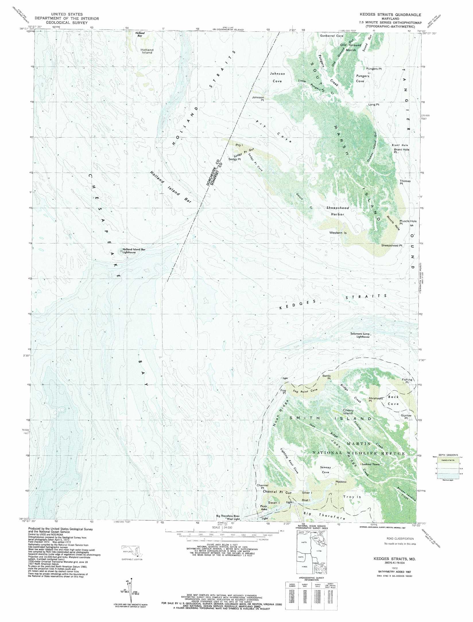
USGS Topo Quad 38076a1 - 1:24,000 scale
| Topo Map Name: | Kedges Straits |
| USGS Topo Quad ID: | 38076a1 |
| Print Size: | ca. 21 1/4" wide x 27" high |
| Southeast Coordinates: | 38° N latitude / 76° W longitude |
| Map Center Coordinates: | 38.0625° N latitude / 76.0625° W longitude |
| U.S. State: | MD |
| Filename: | p38076a1.jpg |
| Download Map JPG Image: | Kedges Straits topo map 1:24,000 scale |
| Map Type: | Orthophoto |
| Topo Series: | 7.5´ |
| Map Scale: | 1:24,000 |
| Source of Map Images: | United States Geological Survey (USGS) |
| Alternate Map Versions: |
Kedges Straits MD 1942, updated 1957 Download PDF Buy paper map Kedges Straits MD 1972, updated 1975 Download PDF Buy paper map Kedges Straits MD 1972, updated 1987 Download PDF Buy paper map Kedges Straits MD 2011 Download PDF Buy paper map Kedges Straits MD 2014 Download PDF Buy paper map Kedges Straits MD 2016 Download PDF Buy paper map |
1:24,000 Topo Quads surrounding Kedges Straits
Barren Island |
Honga |
Wingate |
Nanticoke |
Wetipquin |
Point No Point |
Richland Point |
Bloodsworth Island |
Deal Island |
Monie |
Point Lookout |
East Of Point Lookout |
Kedges Straits |
Terrapin Sand Point |
Marion |
Burgess |
Smith Point |
Ewell |
Great Fox Island |
Crisfield |
Reedville |
East of Reedville |
Goose Island |
Tangier Island |
Chesconessex |
> Back to 38076a1 at 1:100,000 scale
> Back to 38076a1 at 1:250,000 scale
> Back to U.S. Topo Maps home
Kedges Straits topo map: Gazetteer
Kedges Straits: Areas
Old Ground elevation 0m 0′Kedges Straits: Bars
Musclehole Bar elevation 0m 0′Solomons Lump elevation 0m 0′
Kedges Straits: Bays
Brant Hole elevation 0m 0′Bridge Creek elevation 0m 0′
Fog Point Cove elevation 0m 0′
Gunbarrel Cove elevation 0m 0′
Johnson Cove elevation 0m 0′
Lighting Knot Cove elevation 0m 0′
Muscle Hole elevation 0m 0′
North End Bottom elevation 0m 0′
Oyster Cove elevation 0m 0′
Pry Cove elevation 0m 0′
Pungers Cove elevation 0m 0′
Pungers Creek elevation 0m 0′
Sedgy Point Cove elevation 0m 0′
Sheepshead Harbor elevation 0m 0′
Swaney Cove elevation 0m 0′
Kedges Straits: Capes
Bards Point elevation 0m 0′Brant Hole Point elevation 0m 0′
Channel Point elevation 0m 0′
Fishing Point elevation 0m 0′
Fog Point elevation 0m 0′
Gunlow Point elevation 0m 0′
Johnson Point elevation 0m 0′
Long Point elevation 0m 0′
Muscle Hole Point elevation 1m 3′
Pungers Point elevation 0m 0′
Sedgy Point elevation 0m 0′
Sheepshead Point elevation 0m 0′
Thomas Point elevation 0m 0′
Kedges Straits: Channels
Fishing Creek elevation 0m 0′Joes Ridge Creek elevation 0m 0′
Kedges Straits elevation 0m 0′
Little Pungers Creek elevation 4m 13′
Kedges Straits: Guts
Channel Point Gut elevation 0m 0′Sedgy Point Gut elevation 0m 0′
Thomas Island Gut elevation 0m 0′
Kedges Straits: Islands
Boat Island elevation 0m 0′Cherry Island elevation 0m 0′
Holland Island elevation -1m -4′
Jones Island elevation 0m 0′
Maddox Island elevation 0m 0′
Pry Island elevation 1m 3′
Silver Island elevation 0m 0′
Swan Island elevation 0m 0′
Troy Island elevation 0m 0′
Western Islands elevation 0m 0′
Kedges Straits: Parks
Martin National Wildlife Refuge elevation 0m 0′Kedges Straits: Ridges
Joes Ridge elevation 0m 0′Noah Ridge elevation 0m 0′
Kedges Straits: Streams
Goose Creek elevation 1m 3′Old Ground Gut elevation 2m 6′
Sound Gut elevation 0m 0′
Kedges Straits: Swamps
Old Ground Marsh elevation 1m 3′Kedges Straits digital topo map on disk
Buy this Kedges Straits topo map showing relief, roads, GPS coordinates and other geographical features, as a high-resolution digital map file on DVD:
Atlantic Coast (NY, NJ, PA, DE, MD, VA, NC)
Buy digital topo maps: Atlantic Coast (NY, NJ, PA, DE, MD, VA, NC)
 map DVD")